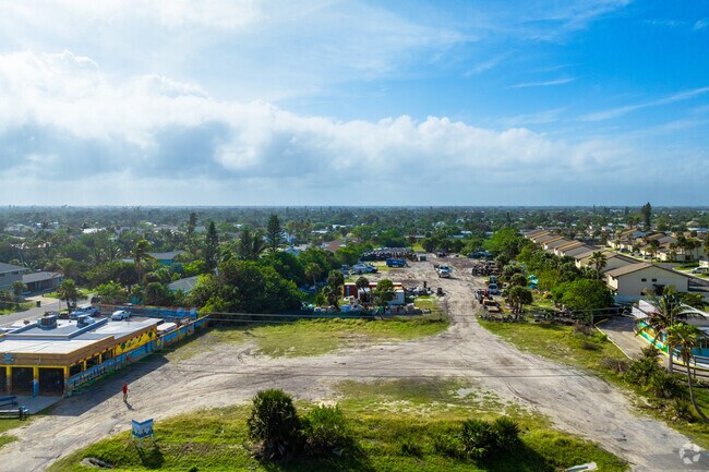
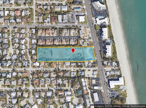
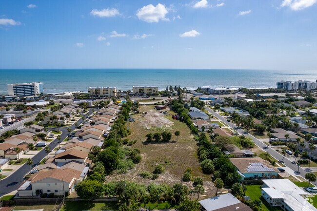
Property Record
1230 Highway A1a, Satellite Beach, FL 32937

NEARBY LISTINGS FOR SALE OR LEASE
Property Detail
1230 Highway A1a
Palm Bay-Melbourne-Titusville, FL
S 200 FT OF N 500 FT OF GOVT LOT 3 W OF A1A EXC ORB 5843 PG 9656 PAR 752.1
26-37-35-00-00752.0-0000.00
Brevard
Commercialacreage
Florida
X
3
12009C0537H
3.72 AC
2024
Brevard County
2025
Orlando
066700
DEMOGRAPHICS near 1230 Highway A1a
1 Mile
3 Mile
5 Mile
2024 Total Population
7,141
30,261
66,194
2029 Population
7,770
33,079
72,089
Pop Growth 2024-2029
+ 8.81%
+ 9.31%
+ 8.91%
Average Age
44
46
45
2024 Total Households
2,966
13,115
29,246
HH Growth 2024-2029
+ 8.56%
+ 9.11%
+ 8.68%
Median Household Inc
$95,209
$84,638
$73,470
Avg Household Size
2.40
2.30
2.20
2024 Avg HH Vehicles
2.00
2.00
2.00
Median Home Value
$358,704
$367,414
$319,642
Median Year Built
1972
1975
1980
Nearby Places
Map Layers
Map Styles
 Street
 Aerial
- Restaurants
- Banks
- Shops
- Fitness
- Groceries
PUBLIC TRANSPORTATION
AIRPORT
Melbourne Orlando International
DRIVE
WALK
Distance
Melbourne Orlando International
25 min
10.5 mi
Freight Ports
Port Canaveral
DRIVE
WALK
Distance
Port Canaveral
33 min
16.3 mi
SALE & LEASE HISTORY
LISTING DATE
SALE/LEASE

Mar 01, 2022
For Sale
Jun 27, 2018
For Sale
Jul 18, 2018
For Lease
Jan 17, 2017
For Sale
Feb 28, 2017
For Sale
Nearby Properties
Address
Land Use
TOTAL SIZE
Lot Size
Zoning
Address
Land Use
TOTAL SIZE
Lot Size
Zoning
1,339.40 AC
Address
Land Use
TOTAL SIZE
Lot Size
Zoning
511,907 SF
75.60 AC
ITU
Address
Land Use
TOTAL SIZE
Lot Size
Zoning
289,263 SF
13.96 AC
R2
Address
Land Use
TOTAL SIZE
Lot Size
Zoning
225,168 SF
7.06 AC
R3
Address
Land Use
TOTAL SIZE
Lot Size
Zoning
252,942 SF
29.76 AC
R3
Address
Land Use
TOTAL SIZE
Lot Size
Zoning
162,759 SF
8.49 AC
RU230
Address
Land Use
TOTAL SIZE
Lot Size
Zoning
90.10 AC
Address
Land Use
TOTAL SIZE
Lot Size
Zoning
182,969 SF
14.64 AC
B1
Address
Land Use
TOTAL SIZE
Lot Size
Zoning
94,097 SF
3.21 AC
R2
Address
Land Use
TOTAL SIZE
Lot Size
Zoning
118,607 SF
9.67 AC
CP
Address
Land Use
TOTAL SIZE
Lot Size
Zoning
106,333 SF
2.52 AC
B1
Address
Land Use
TOTAL SIZE
Lot Size
Zoning
7.02 AC
ITU
Address
Land Use
TOTAL SIZE
Lot Size
Zoning
75,076 SF
3.67 AC
RU215
Address
Land Use
TOTAL SIZE
Lot Size
Zoning
152,762 SF
13.70 AC
C
Address
Land Use
TOTAL SIZE
Lot Size
Zoning
2,792 SF
6.36 AC
ITU
Address
Land Use
TOTAL SIZE
Lot Size
Zoning
144,052 SF
13.28 AC
B1
Address
Land Use
TOTAL SIZE
Lot Size
Zoning
742 SF
2.04 AC
GML
Address
Land Use
TOTAL SIZE
Lot Size
Zoning
52,325 SF
2.40 AC
C1
Address
Land Use
TOTAL SIZE
Lot Size
Zoning
55,552 SF
1.50 AC
Address
Land Use
TOTAL SIZE
Lot Size
Zoning
72,781 SF
9.54 AC
IN(L)
Address
Land Use
TOTAL SIZE
Lot Size
Zoning
99,628 SF
9.97 AC
CP
Address
Land Use
TOTAL SIZE
Lot Size
Zoning
108,296 SF
3.52 AC
Address
Land Use
TOTAL SIZE
Lot Size
Zoning
33,556 SF
1.04 AC
R3
Address
Land Use
TOTAL SIZE
Lot Size
Zoning
1,043 SF
5.73 AC
GML
Address
Land Use
TOTAL SIZE
Lot Size
Zoning
78,050 SF
6.26 AC
CP
Address
Land Use
TOTAL SIZE
Lot Size
Zoning
56,927 SF
6.87 AC
CP
Address
Land Use
TOTAL SIZE
Lot Size
Zoning
66,611 SF
14 AC
P2
Address
Land Use
TOTAL SIZE
Lot Size
Zoning
27,825 SF
5.70 AC
B1
Address
Land Use
TOTAL SIZE
Lot Size
Zoning
63,316 SF
4.03 AC
R210
Address
Land Use
TOTAL SIZE
Lot Size
Zoning
52,726 SF
12.51 AC
RU111
The World's #1 Commercial Real Estate Marketplace
Connect with us
© 2025 CoStar Group
The information above has been obtained from sources believed reliable. While we do not doubt its accuracy we have not verified it and make no guarantee, warranty or representation about it. It is your responsibility to independently confirm its accuracy and completeness. Any projections, opinions, assumptions, or estimates used are for example only and do not represent the current or future performance of the property. The value of this transaction to you depends on tax and other factors which should be evaluated by your tax, financial, and legal advisors. You and your advisors should conduct a careful, independent investigation of the property to determine to your satisfaction the suitability of the property for your needs.