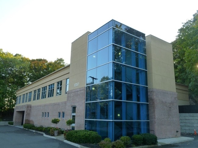
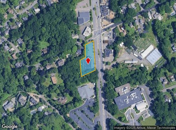
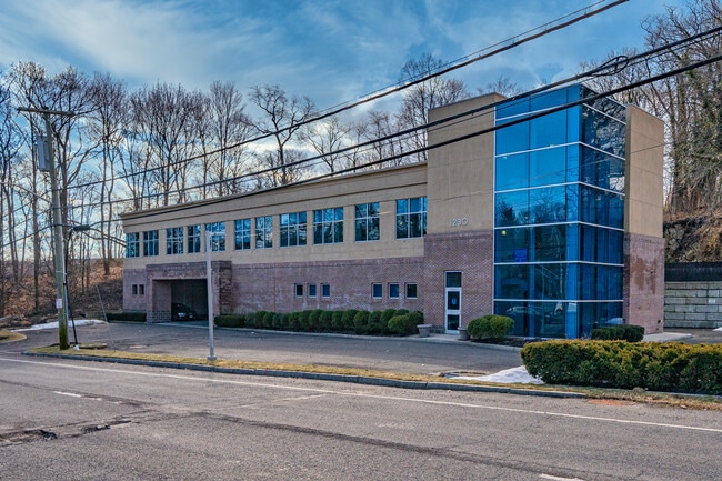
Property Record
1230 Mamaroneck Ave, White Plains, NY 10605
NEARBY LISTINGS FOR SALE OR LEASE
Property Detail
1230 Mamaroneck Ave
1700-138-014-00011-000-0003
Westchester
Professionalbldglegalinsurancerealestateetc
New York
X
3.000
36119C0351F
0.86 AC
2025
East I-287 Corridor
2024
Westchester/So Connecticut
009701
New York-Jersey City-White Plains, NY-NJ
10,000 SF
DEMOGRAPHICS near 1230 Mamaroneck Ave
1 Mile
3 Mile
5 Mile
2024 Total Population
5,747
93,448
298,313
2029 Population
5,716
91,683
292,445
Pop Growth 2024-2029
(0.54%)
(1.89%)
(1.97%)
Average Age
45
41
42
2024 Total Households
1,924
32,363
108,474
HH Growth 2024-2029
(0.57%)
(1.95%)
(2.00%)
Median Household Inc
$200,932
$158,747
$139,562
Avg Household Size
2.90
2.80
2.60
2024 Avg HH Vehicles
2.00
2.00
2.00
Median Home Value
$933,030
$868,531
$765,614
Median Year Built
1966
1956
1956
Nearby Places
Map Layers
Map Styles
 Street
 Aerial
- Restaurants
- Banks
- Shops
- Fitness
- Groceries
PUBLIC TRANSPORTATION
COMMUTER RAIL
Mamaroneck Station (New Haven Line - Metro-North Commuter Railroad Company (Metro-North))
DRIVE
WALK
Distance
Mamaroneck Station (New Haven Line - Metro-North Commuter Railroad Company (Metro-North))
7 min
3.1 mi
Harrison Station (New Haven Line - Metro-North Commuter Railroad Company (Metro-North))
DRIVE
WALK
Distance
Harrison Station (New Haven Line - Metro-North Commuter Railroad Company (Metro-North))
10 min
4.9 mi
AIRPORT
Westchester County
DRIVE
WALK
Distance
Westchester County
15 min
9.6 mi
LaGuardia
DRIVE
WALK
Distance
LaGuardia
35 min
21.1 mi
John F Kennedy International
DRIVE
WALK
Distance
John F Kennedy International
41 min
28.7 mi
Freight Ports
NY - Red Hook Container Terminal
DRIVE
WALK
Distance
NY - Red Hook Container Terminal
50 min
31.6 mi
SALE & LEASE HISTORY
LISTING DATE
SALE/LEASE

Sep 25, 2016
For Lease
Oct 25, 2016
For Lease
Mar 28, 2017
For Lease
Mar 13, 2017
For Lease
Jun 19, 2019
For Lease
Jun 06, 2019
For Lease
Jun 06, 2019
For Lease
Nearby Properties
Address
Land Use
TOTAL SIZE
Lot Size
Zoning
Address
Land Use
TOTAL SIZE
Lot Size
Zoning
Address
Land Use
TOTAL SIZE
Lot Size
Zoning
381,836 SF
16.68 AC
A3
Address
Land Use
TOTAL SIZE
Lot Size
Zoning
Address
Land Use
TOTAL SIZE
Lot Size
Zoning
237,313 SF
22.67 AC
A1
Address
Land Use
TOTAL SIZE
Lot Size
Zoning
125,010 SF
4.02 AC
Address
Land Use
TOTAL SIZE
Lot Size
Zoning
21.33 AC
Address
Land Use
TOTAL SIZE
Lot Size
Zoning
82,895 SF
23.03 AC
A2
Address
Land Use
TOTAL SIZE
Lot Size
Zoning
188.31 AC
Address
Land Use
TOTAL SIZE
Lot Size
Zoning
67.51 AC
Address
Land Use
TOTAL SIZE
Lot Size
Zoning
5COMMUND
Address
Land Use
TOTAL SIZE
Lot Size
Zoning
5.57 AC
AA1
Address
Land Use
TOTAL SIZE
Lot Size
Zoning
48,499 SF
8.52 AC
A2/A3
Address
Land Use
TOTAL SIZE
Lot Size
Zoning
61,606 SF
19.99 AC
A4/A3
Address
Land Use
TOTAL SIZE
Lot Size
Zoning
48,267 SF
11.04 AC
A2 A
Address
Land Use
TOTAL SIZE
Lot Size
Zoning
6.31 AC
R-5 SFR
Address
Land Use
TOTAL SIZE
Lot Size
Zoning
37,187 SF
2.62 AC
Address
Land Use
TOTAL SIZE
Lot Size
Zoning
67,917 SF
6.79 AC
A4
Address
Land Use
TOTAL SIZE
Lot Size
Zoning
34,454 SF
216.47 AC
Address
Land Use
TOTAL SIZE
Lot Size
Zoning
68,022 SF
4.31 AC
Address
Land Use
TOTAL SIZE
Lot Size
Zoning
2,100 SF
24.12 AC
A3
Address
Land Use
TOTAL SIZE
Lot Size
Zoning
21,524 SF
11.06 AC
A2 A
Address
Land Use
TOTAL SIZE
Lot Size
Zoning
28,500 SF
5.32 AC
R-20 SFR
Address
Land Use
TOTAL SIZE
Lot Size
Zoning
29,990 SF
9.75 AC
A3
Address
Land Use
TOTAL SIZE
Lot Size
Zoning
29,405 SF
0.80 AC
A3
Address
Land Use
TOTAL SIZE
Lot Size
Zoning
49,865 SF
3 AC
A3
Address
Land Use
TOTAL SIZE
Lot Size
Zoning
32,612 SF
138.70 AC
AA1/A
Address
Land Use
TOTAL SIZE
Lot Size
Zoning
12,093 SF
0.50 AC
A5
Address
Land Use
TOTAL SIZE
Lot Size
Zoning
61,200 SF
0.57 AC
C2
Address
Land Use
TOTAL SIZE
Lot Size
Zoning
27.22 AC
A2/A3
Address
Land Use
TOTAL SIZE
Lot Size
Zoning
25,135 SF
2.76 AC
A3
The World's #1 Commercial Real Estate Marketplace
Connect with us
© 2025 CoStar Group
The information above has been obtained from sources believed reliable. While we do not doubt its accuracy we have not verified it and make no guarantee, warranty or representation about it. It is your responsibility to independently confirm its accuracy and completeness. Any projections, opinions, assumptions, or estimates used are for example only and do not represent the current or future performance of the property. The value of this transaction to you depends on tax and other factors which should be evaluated by your tax, financial, and legal advisors. You and your advisors should conduct a careful, independent investigation of the property to determine to your satisfaction the suitability of the property for your needs.