Property Record
12300 Wirth Dr, Manchaca, TX 78652

Save to a Folder
{{folder.Name}}
{{folder.ListingIds.length}} Properties
{{folder.ListingIds.length}} Property
Create a New Folder
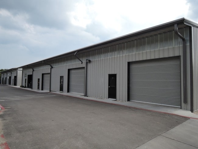
Property Detail
12300 Wirth Dr
351116
ABS 27 SUR 2 WILSON W ACR 1.00
Warehouse
Travis
B and X Area of moderate flood hazard, usually the area between the limits of the 100-year and 500-year floods.
Texas
2025
1 AC
2025
South
033200
Austin
17,920 SF
Austin-Round Rock-San Marcos, TX
NEARBY LISTINGS FOR SALE OR LEASE
DEMOGRAPHICS near 12300 Wirth Dr
1 mile
3 mile
5 mile
2025 Total Population
5,098
60,205
167,681
2030 Population
5,403
63,377
179,195
Pop Growth 2025-2030
+ 5.98%
+ 5.27%
+ 6.87%
Average Age
38
39
39
2025 Total Households
1,993
24,807
67,839
HH Growth 2025-2030
+ 6.67%
+ 6.02%
+ 7.46%
Median Household Inc
$117,117
$106,325
$102,189
Avg Household Size
2.50
2.40
2.40
2025 Avg HH Vehicles
2.00
2.00
2.00
Median Home Value
$450,116
$516,915
$495,037
Median Year Built
2010
2007
2006
Nearby Places
Map Layers
Map Styles
 Street
 Aerial
Layers
 Traffic
 Biking
Places
Listings with unknown addresses are not visible on the map
- Restaurants
- Banks
- Shops
- Fitness
- Groceries
PUBLIC TRANSPORTATION
AIRPORT
Austin-Bergstrom International
Drive
Walk
Distance
Austin-Bergstrom International
31 min
16.6 mi
Freight Ports
Calhoun Port
Drive
Walk
Distance
Calhoun Port
181 min
151.5 mi
SALE & LEASE HISTORY
LISTING DATE
SALE/LEASE

Sep 14, 2017
For Lease
Nearby Properties
Address
Land Use
TOTAL SIZE
Lot Size
Zoning
Address
Land Use
TOTAL SIZE
Lot Size
Zoning
450,836 SF
29.58 AC
Address
Land Use
TOTAL SIZE
Lot Size
Zoning
380,191 SF
37.33 AC
Address
Land Use
TOTAL SIZE
Lot Size
Zoning
408,828 SF
43.52 AC
Address
Land Use
TOTAL SIZE
Lot Size
Zoning
331,650 SF
19.33 AC
Address
Land Use
TOTAL SIZE
Lot Size
Zoning
374,720 SF
26.96 AC
Address
Land Use
TOTAL SIZE
Lot Size
Zoning
330,491 SF
19.37 AC
Address
Land Use
TOTAL SIZE
Lot Size
Zoning
414,030 SF
55.96 AC
Address
Land Use
TOTAL SIZE
Lot Size
Zoning
320,000 SF
7.44 AC
Address
Land Use
TOTAL SIZE
Lot Size
Zoning
384,254 SF
24.13 AC
Address
Land Use
TOTAL SIZE
Lot Size
Zoning
286,614 SF
15.81 AC
Address
Land Use
TOTAL SIZE
Lot Size
Zoning
328,606 SF
42.16 AC
Address
Land Use
TOTAL SIZE
Lot Size
Zoning
281,107 SF
15.91 AC
Address
Land Use
TOTAL SIZE
Lot Size
Zoning
316,572 SF
22.67 AC
Address
Land Use
TOTAL SIZE
Lot Size
Zoning
312,800 SF
32.06 AC
Address
Land Use
TOTAL SIZE
Lot Size
Zoning
244,746 SF
12.24 AC
Address
Land Use
TOTAL SIZE
Lot Size
Zoning
244,365 SF
11.87 AC
Address
Land Use
TOTAL SIZE
Lot Size
Zoning
245,086 SF
11.94 AC
Address
Land Use
TOTAL SIZE
Lot Size
Zoning
278,070 SF
23.97 AC
Address
Land Use
TOTAL SIZE
Lot Size
Zoning
288,750 SF
14.86 AC
Address
Land Use
TOTAL SIZE
Lot Size
Zoning
263,100 SF
15.97 AC
Address
Land Use
TOTAL SIZE
Lot Size
Zoning
237,911 SF
13.22 AC
Address
Land Use
TOTAL SIZE
Lot Size
Zoning
262,350 SF
15.30 AC
Address
Land Use
TOTAL SIZE
Lot Size
Zoning
249,155 SF
17.60 AC
Address
Land Use
TOTAL SIZE
Lot Size
Zoning
243,351 SF
14.07 AC
Address
Land Use
TOTAL SIZE
Lot Size
Zoning
228,514 SF
13.58 AC
Address
Land Use
TOTAL SIZE
Lot Size
Zoning
306,900 SF
16 AC
Address
Land Use
TOTAL SIZE
Lot Size
Zoning
175,200 SF
9.16 AC
Address
Land Use
TOTAL SIZE
Lot Size
Zoning
231,000 SF
3.39 AC
Address
Land Use
TOTAL SIZE
Lot Size
Zoning
250,204 SF
19.28 AC
Address
Land Use
TOTAL SIZE
Lot Size
Zoning
200,953 SF
7.24 AC
The World's #1 Commercial Real Estate Marketplace
Connect with us
© 2026 CoStar Group
The information above has been obtained from sources believed reliable. While we do not doubt its accuracy we have not verified it and make no guarantee, warranty or representation about it. It is your responsibility to independently confirm its accuracy and completeness. Any projections, opinions, assumptions, or estimates used are for example only and do not represent the current or future performance of the property. The value of this transaction to you depends on tax and other factors which should be evaluated by your tax, financial, and legal advisors. You and your advisors should conduct a careful, independent investigation of the property to determine to your satisfaction the suitability of the property for your needs.