Property Record
12301 3Rd St, Yucaipa, CA 92399
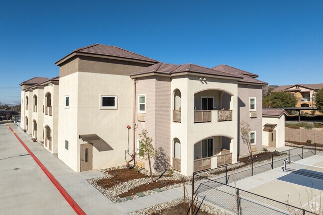

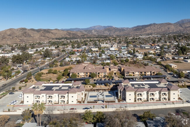
This Property Is For Sale
Property Detail
12301 3Rd St
0319-351-02
REVISED MAP OF YUCAIPA CITY PTN BLKS 112 AND 140 COM 153.2 FT N OF SW COR SD BLK 112 TH N 132 FT TH E 660 FT TO PT 594 FT N OF SE COR BLK 140 TH S TO PT 462 FT N OF SE COR SD BLK 140 TH W 660 FT TO POB 1.99 AC
Apartment
San Bernardino
B and X Area of moderate flood hazard, usually the area between the limits of the 100-year and 500-year floods.
California
2025
1.91 AC
2025
Yucaipa
008800
Inland Empire (California)
42,634 SF
Riverside-San Bernardino-Ontario, CA
NEARBY LISTINGS FOR SALE OR LEASE
DEMOGRAPHICS near 12301 3Rd St
1 mile
3 mile
5 mile
2025 Total Population
17,885
59,172
78,783
2030 Population
18,294
60,223
80,463
Pop Growth 2025-2030
+ 2.29%
+ 1.78%
+ 2.13%
Average Age
39
40
41
2025 Total Households
6,714
21,189
28,072
HH Growth 2025-2030
+ 2.28%
+ 1.75%
+ 2.05%
Median Household Inc
$73,509
$93,594
$96,826
Avg Household Size
2.60
2.80
2.80
2025 Avg HH Vehicles
2.00
2.00
2.00
Median Home Value
$434,619
$530,134
$563,578
Median Year Built
1968
1977
1981
Nearby Places
Map Layers
Map Styles
 Street
 Aerial
Layers
 Traffic
 Biking
Places
Listings with unknown addresses are not visible on the map
- Restaurants
- Banks
- Shops
- Fitness
- Groceries
PUBLIC TRANSPORTATION
COMMUTER RAIL
Redlands - University Metrolink Station (Metrolink San Bernardino Line - Metrolink Trains)
Drive
Walk
Distance
Redlands - University Metrolink Station (Metrolink San Bernardino Line - Metrolink Trains)
14 min
8.5 mi
Redlands - Downtown Metrolink Station (Metrolink San Bernardino Line - Metrolink Trains)
Drive
Walk
Distance
Redlands - Downtown Metrolink Station (Metrolink San Bernardino Line - Metrolink Trains)
16 min
9.6 mi
Freight Ports
Port of Long Beach
Drive
Walk
Distance
Port of Long Beach
102 min
79.4 mi
Nearby Properties
Address
Land Use
TOTAL SIZE
Lot Size
Zoning
Address
Land Use
TOTAL SIZE
Lot Size
Zoning
369,838 SF
19.32 AC
Address
Land Use
TOTAL SIZE
Lot Size
Zoning
102,506 SF
4.47 AC
Address
Land Use
TOTAL SIZE
Lot Size
Zoning
82,694 SF
3.41 AC
Address
Land Use
TOTAL SIZE
Lot Size
Zoning
5.47 AC
Address
Land Use
TOTAL SIZE
Lot Size
Zoning
79,299 SF
5.04 AC
Address
Land Use
TOTAL SIZE
Lot Size
Zoning
67,686 SF
4.16 AC
Address
Land Use
TOTAL SIZE
Lot Size
Zoning
56,491 SF
7.50 AC
Address
Land Use
TOTAL SIZE
Lot Size
Zoning
56,491 SF
3.39 AC
Address
Land Use
TOTAL SIZE
Lot Size
Zoning
22,308 SF
1.87 AC
Address
Land Use
TOTAL SIZE
Lot Size
Zoning
24,510 SF
6.88 AC
Address
Land Use
TOTAL SIZE
Lot Size
Zoning
49,320 SF
1.68 AC
Address
Land Use
TOTAL SIZE
Lot Size
Zoning
49,952 SF
4.34 AC
Address
Land Use
TOTAL SIZE
Lot Size
Zoning
29,387 SF
3.21 AC
Address
Land Use
TOTAL SIZE
Lot Size
Zoning
27,627 SF
5.07 AC
Address
Land Use
TOTAL SIZE
Lot Size
Zoning
111,182 SF
3.11 AC
Address
Land Use
TOTAL SIZE
Lot Size
Zoning
15,980 SF
1.56 AC
Address
Land Use
TOTAL SIZE
Lot Size
Zoning
44,046 SF
3.77 AC
Address
Land Use
TOTAL SIZE
Lot Size
Zoning
33,000 SF
2.96 AC
Address
Land Use
TOTAL SIZE
Lot Size
Zoning
41,005 SF
3.27 AC
MIX
Address
Land Use
TOTAL SIZE
Lot Size
Zoning
78,309 SF
7.09 AC
Address
Land Use
TOTAL SIZE
Lot Size
Zoning
29,996 SF
1.86 AC
Address
Land Use
TOTAL SIZE
Lot Size
Zoning
73,670 SF
4.49 AC
Address
Land Use
TOTAL SIZE
Lot Size
Zoning
9.71 AC
Address
Land Use
TOTAL SIZE
Lot Size
Zoning
1,970 SF
6.27 AC
Address
Land Use
TOTAL SIZE
Lot Size
Zoning
41,040 SF
4.70 AC
Address
Land Use
TOTAL SIZE
Lot Size
Zoning
23,227 SF
1.81 AC
Address
Land Use
TOTAL SIZE
Lot Size
Zoning
18,800 SF
4.07 AC
CC
Address
Land Use
TOTAL SIZE
Lot Size
Zoning
14,738 SF
1.49 AC
C1
Address
Land Use
TOTAL SIZE
Lot Size
Zoning
45,862 SF
4.51 AC
The World's #1 Commercial Real Estate Marketplace
Connect with us
© 2026 CoStar Group
The information above has been obtained from sources believed reliable. While we do not doubt its accuracy we have not verified it and make no guarantee, warranty or representation about it. It is your responsibility to independently confirm its accuracy and completeness. Any projections, opinions, assumptions, or estimates used are for example only and do not represent the current or future performance of the property. The value of this transaction to you depends on tax and other factors which should be evaluated by your tax, financial, and legal advisors. You and your advisors should conduct a careful, independent investigation of the property to determine to your satisfaction the suitability of the property for your needs.