Property Record
12301 Sw Robert Crain Hwy, Brandywine, MD 20613
NEARBY LISTINGS FOR SALE OR LEASE
Property Detail
12301 Sw Robert Crain Hwy
Washington-Arlington-Alexandria, DC-VA-MD-WV
(OUT CYCLE FIN NO CHG 10)
11-4010104
Prince George's
Industrialgeneral
Maryland
X
2
24033C0355E
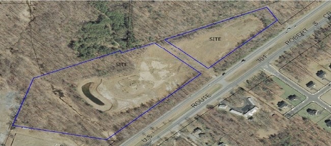
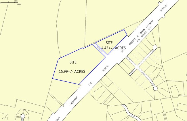
15.99 AC
2023
Outlying PG County South
2025
Washington, DC
801005
DEMOGRAPHICS near 12301 Sw Robert Crain Hwy
1 Mile
3 Mile
5 Mile
2024 Total Population
765
20,974
62,857
2029 Population
761
20,593
61,509
Pop Growth 2024-2029
(0.52%)
(1.82%)
(2.14%)
Average Age
42
43
43
2024 Total Households
254
7,115
21,815
HH Growth 2024-2029
(0.79%)
(1.71%)
(2.17%)
Median Household Inc
$141,128
$126,386
$122,062
Avg Household Size
2.80
2.90
2.80
2024 Avg HH Vehicles
2.00
2.00
2.00
Median Home Value
$476,829
$433,814
$399,466
Median Year Built
1992
1993
1989
Nearby Places
Map Layers
Map Styles
 Street
 Aerial
- Restaurants
- Banks
- Shops
- Fitness
- Groceries
PUBLIC TRANSPORTATION
AIRPORT
Ronald Reagan Washington Ntl
DRIVE
WALK
Distance
Ronald Reagan Washington Ntl
38 min
23.4 mi
Freight Ports
Port of Baltimore
DRIVE
WALK
Distance
Port of Baltimore
67 min
46.3 mi
SALE & LEASE HISTORY
LISTING DATE
SALE/LEASE

Sep 24, 2016
For Sale
Mar 30, 2017
For Sale
Jan 16, 2018
For Lease
Nearby Properties
Address
Land Use
TOTAL SIZE
Lot Size
Zoning
Address
Land Use
TOTAL SIZE
Lot Size
Zoning
801,684 SF
34.05 AC
IE
Address
Land Use
TOTAL SIZE
Lot Size
Zoning
7,000 SF
354.62 AC
ROS
Address
Land Use
TOTAL SIZE
Lot Size
Zoning
341,372 SF
14.74 AC
RR
Address
Land Use
TOTAL SIZE
Lot Size
Zoning
388,608 SF
28.45 AC
LCD
Address
Land Use
TOTAL SIZE
Lot Size
Zoning
76,906 SF
168.92 AC
AG
Address
Land Use
TOTAL SIZE
Lot Size
Zoning
126,592 SF
58.79 AC
ROS
Address
Land Use
TOTAL SIZE
Lot Size
Zoning
939.06 AC
RR
Address
Land Use
TOTAL SIZE
Lot Size
Zoning
78,658 SF
9.13 AC
RR
Address
Land Use
TOTAL SIZE
Lot Size
Zoning
61,836 SF
9.63 AC
IE
Address
Land Use
TOTAL SIZE
Lot Size
Zoning
127,206 SF
2.90 AC
TACE
Address
Land Use
TOTAL SIZE
Lot Size
Zoning
48,146 SF
4.48 AC
RR
Address
Land Use
TOTAL SIZE
Lot Size
Zoning
87 AC
IH
Address
Land Use
TOTAL SIZE
Lot Size
Zoning
137,226 SF
25.66 AC
RR
Address
Land Use
TOTAL SIZE
Lot Size
Zoning
44,710 SF
10.05 AC
ROS
Address
Land Use
TOTAL SIZE
Lot Size
Zoning
24,570 SF
39.87 AC
IE
Address
Land Use
TOTAL SIZE
Lot Size
Zoning
21,720 SF
10 AC
RR
Address
Land Use
TOTAL SIZE
Lot Size
Zoning
152,431 SF
11.12 AC
RR
Address
Land Use
TOTAL SIZE
Lot Size
Zoning
25.21 AC
IE
Address
Land Use
TOTAL SIZE
Lot Size
Zoning
6,908 SF
3.34 AC
CS
Address
Land Use
TOTAL SIZE
Lot Size
Zoning
14,763 SF
1.96 AC
CS
Address
Land Use
TOTAL SIZE
Lot Size
Zoning
1,986 SF
47.96 AC
IH
Address
Land Use
TOTAL SIZE
Lot Size
Zoning
38,660 SF
9.11 AC
RSF95
Address
Land Use
TOTAL SIZE
Lot Size
Zoning
87,874 SF
14.71 AC
RR
Address
Land Use
TOTAL SIZE
Lot Size
Zoning
1,496 SF
1.72 AC
TACE
Address
Land Use
TOTAL SIZE
Lot Size
Zoning
20,858 SF
5.12 AC
RR
Address
Land Use
TOTAL SIZE
Lot Size
Zoning
18,000 SF
26.68 AC
RR
Address
Land Use
TOTAL SIZE
Lot Size
Zoning
137.39 AC
LCD
Address
Land Use
TOTAL SIZE
Lot Size
Zoning
28,855 SF
10.19 AC
RR
Address
Land Use
TOTAL SIZE
Lot Size
Zoning
15,100 SF
8.82 AC
AR
Address
Land Use
TOTAL SIZE
Lot Size
Zoning
403.77 AC
ROS
The World's #1 Commercial Real Estate Marketplace
Connect with us
© 2026 CoStar Group
The information above has been obtained from sources believed reliable. While we do not doubt its accuracy we have not verified it and make no guarantee, warranty or representation about it. It is your responsibility to independently confirm its accuracy and completeness. Any projections, opinions, assumptions, or estimates used are for example only and do not represent the current or future performance of the property. The value of this transaction to you depends on tax and other factors which should be evaluated by your tax, financial, and legal advisors. You and your advisors should conduct a careful, independent investigation of the property to determine to your satisfaction the suitability of the property for your needs.