Property Record
12301 Vance Davis Dr, Charlotte, NC 28269


NEARBY LISTINGS FOR SALE OR LEASE
Property Detail
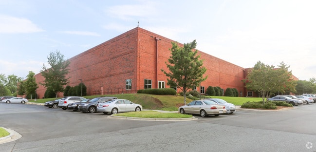
12301 Vance Davis Dr
Charlotte-Concord-Gastonia, NC-SC
Twin Lakes Bus Park Ph 02
025-063-11
P20 M29-60
Industrialgeneral
Mecklenburg
X
North Carolina
3710455900K
11
2024
30.10 AC
2025
North
005508
Charlotte
315,548 SF
DEMOGRAPHICS near 12301 Vance Davis Dr
1 Mile
3 Mile
5 Mile
2024 Total Population
1,993
53,209
154,049
2029 Population
2,182
56,634
163,602
Pop Growth 2024-2029
+ 9.48%
+ 6.44%
+ 6.20%
Average Age
37
36
37
2024 Total Households
748
21,546
59,056
HH Growth 2024-2029
+ 9.63%
+ 6.49%
+ 6.23%
Median Household Inc
$116,176
$77,419
$80,124
Avg Household Size
2.70
2.40
2.50
2024 Avg HH Vehicles
2.00
2.00
2.00
Median Home Value
$317,928
$278,722
$289,667
Median Year Built
2010
2003
2001
Nearby Places
Map Layers
Map Styles
 Street
 Aerial
- Restaurants
- Banks
- Shops
- Fitness
- Groceries
PUBLIC TRANSPORTATION
AIRPORT
Concord-Padgett Regional
DRIVE
WALK
Distance
Concord-Padgett Regional
14 min
8.0 mi
Charlotte/Douglas International
DRIVE
WALK
Distance
Charlotte/Douglas International
30 min
17.3 mi
Freight Ports
North Charleston Terminal
DRIVE
WALK
Distance
North Charleston Terminal
242 min
209.4 mi
Nearby Properties
Address
Land Use
TOTAL SIZE
Lot Size
Zoning
Address
Land Use
TOTAL SIZE
Lot Size
Zoning
497,730 SF
32.66 AC
B2CD
Address
Land Use
TOTAL SIZE
Lot Size
Zoning
719,240 SF
55.73 AC
CC
Address
Land Use
TOTAL SIZE
Lot Size
Zoning
481,045 SF
36.15 AC
R12MFCD
Address
Land Use
TOTAL SIZE
Lot Size
Zoning
318,829 SF
26.68 AC
MX1INNOV
Address
Land Use
TOTAL SIZE
Lot Size
Zoning
310,576 SF
11.22 AC
Address
Land Use
TOTAL SIZE
Lot Size
Zoning
338,136 SF
15.13 AC
Address
Land Use
TOTAL SIZE
Lot Size
Zoning
15.72 AC
Address
Land Use
TOTAL SIZE
Lot Size
Zoning
256,254 SF
20.66 AC
R9MFCD
Address
Land Use
TOTAL SIZE
Lot Size
Zoning
252,523 SF
7.75 AC
R3
Address
Land Use
TOTAL SIZE
Lot Size
Zoning
295,520 SF
23.13 AC
R12MFCD
Address
Land Use
TOTAL SIZE
Lot Size
Zoning
263,035 SF
10.42 AC
CC
Address
Land Use
TOTAL SIZE
Lot Size
Zoning
334,333 SF
19.33 AC
BP
Address
Land Use
TOTAL SIZE
Lot Size
Zoning
294,175 SF
20.23 AC
R12MFCD
Address
Land Use
TOTAL SIZE
Lot Size
Zoning
246,846 SF
13.56 AC
R3
Address
Land Use
TOTAL SIZE
Lot Size
Zoning
244,003 SF
26.78 AC
R12MFCD
Address
Land Use
TOTAL SIZE
Lot Size
Zoning
284,316 SF
15.50 AC
R22MFCD
Address
Land Use
TOTAL SIZE
Lot Size
Zoning
417,771 SF
14.55 AC
BP
Address
Land Use
TOTAL SIZE
Lot Size
Zoning
490,844 SF
40.50 AC
I-2(CD)
Address
Land Use
TOTAL SIZE
Lot Size
Zoning
304,185 SF
14.32 AC
UR-3(CD)
Address
Land Use
TOTAL SIZE
Lot Size
Zoning
505,355 SF
37.59 AC
Address
Land Use
TOTAL SIZE
Lot Size
Zoning
209,748 SF
12.38 AC
MX1INNOV
Address
Land Use
TOTAL SIZE
Lot Size
Zoning
223,714 SF
16.93 AC
CB
Address
Land Use
TOTAL SIZE
Lot Size
Zoning
211,601 SF
20.80 AC
Address
Land Use
TOTAL SIZE
Lot Size
Zoning
322,342 SF
19.64 AC
R12MFCD
Address
Land Use
TOTAL SIZE
Lot Size
Zoning
220,336 SF
11.52 AC
Address
Land Use
TOTAL SIZE
Lot Size
Zoning
129,017 SF
7.27 AC
CC
Address
Land Use
TOTAL SIZE
Lot Size
Zoning
249,694 SF
41.60 AC
NR
Address
Land Use
TOTAL SIZE
Lot Size
Zoning
209,077 SF
5.76 AC
HC(CD)
Address
Land Use
TOTAL SIZE
Lot Size
Zoning
172,200 SF
8.07 AC
Address
Land Use
TOTAL SIZE
Lot Size
Zoning
221,404 SF
17.13 AC
R15MFCD
The World's #1 Commercial Real Estate Marketplace
Connect with us
© 2026 CoStar Group
The information above has been obtained from sources believed reliable. While we do not doubt its accuracy we have not verified it and make no guarantee, warranty or representation about it. It is your responsibility to independently confirm its accuracy and completeness. Any projections, opinions, assumptions, or estimates used are for example only and do not represent the current or future performance of the property. The value of this transaction to you depends on tax and other factors which should be evaluated by your tax, financial, and legal advisors. You and your advisors should conduct a careful, independent investigation of the property to determine to your satisfaction the suitability of the property for your needs.