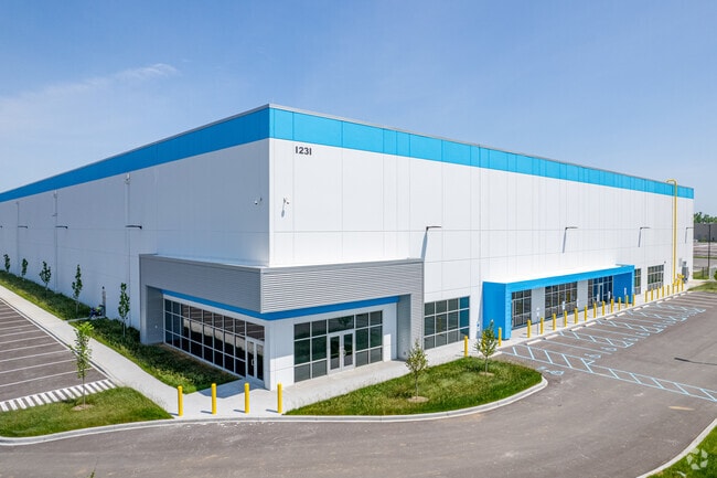
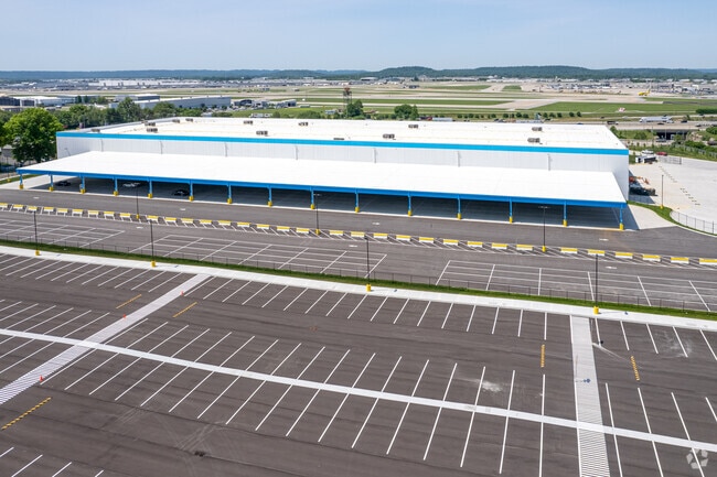
Property Record
1231 Durrett Ln, Louisville, KY 40213


NEARBY LISTINGS FOR SALE OR LEASE
Property Detail
1231 Durrett Ln
085K01860000
Zachary Taylor
Warehouse
26.0799 AC+-
X
Jefferson
21111C0058F
Kentucky
2025
26.08 AC
2025
South Central
011403
Louisville
217,082 SF
Louisville/Jefferson County, KY-IN
DEMOGRAPHICS near 1231 Durrett Ln
1 Mile
3 Mile
5 Mile
2024 Total Population
3,622
75,395
256,809
2029 Population
3,540
74,144
253,895
Pop Growth 2024-2029
(2.26%)
(1.66%)
(1.13%)
Average Age
41
39
39
2024 Total Households
1,613
32,559
111,363
HH Growth 2024-2029
(2.29%)
(1.79%)
(1.11%)
Median Household Inc
$60,414
$49,620
$47,961
Avg Household Size
2.20
2.20
2.20
2024 Avg HH Vehicles
2.00
2.00
1.00
Median Home Value
$161,725
$186,587
$178,173
Median Year Built
1949
1952
1956
Nearby Places
Map Layers
Map Styles
 Street
 Aerial
- Restaurants
- Banks
- Shops
- Fitness
- Groceries
PUBLIC TRANSPORTATION
AIRPORT
Louisville Muhammad Ali International
DRIVE
WALK
Distance
Louisville Muhammad Ali International
11 min
5.1 mi
Freight Ports
Port of Toledo
DRIVE
WALK
Distance
Port of Toledo
358 min
308.2 mi
SALE & LEASE HISTORY
LISTING DATE
SALE/LEASE

Mar 13, 2020
For Lease
Nearby Properties
Address
Land Use
TOTAL SIZE
Lot Size
Zoning
Address
Land Use
TOTAL SIZE
Lot Size
Zoning
42,228 SF
144.63 AC
R5-RESIDEN
Address
Land Use
TOTAL SIZE
Lot Size
Zoning
Address
Land Use
TOTAL SIZE
Lot Size
Zoning
377,041 SF
469.53 AC
Address
Land Use
TOTAL SIZE
Lot Size
Zoning
85,882 SF
80.13 AC
R1-RESIDEN
Address
Land Use
TOTAL SIZE
Lot Size
Zoning
1,584 SF
4.71 AC
R7-RESIDEN
Address
Land Use
TOTAL SIZE
Lot Size
Zoning
Address
Land Use
TOTAL SIZE
Lot Size
Zoning
549,563 SF
26.13 AC
OTF-OFFICE
Address
Land Use
TOTAL SIZE
Lot Size
Zoning
228,447 SF
7.70 AC
M2-INDUSTR
Address
Land Use
TOTAL SIZE
Lot Size
Zoning
398,435 SF
9.93 AC
Address
Land Use
TOTAL SIZE
Lot Size
Zoning
6.75 AC
M2-INDUSTR
Address
Land Use
TOTAL SIZE
Lot Size
Zoning
102,600 SF
173.89 AC
EZ1-ENTERP
Address
Land Use
TOTAL SIZE
Lot Size
Zoning
636,716 SF
33.71 AC
Address
Land Use
TOTAL SIZE
Lot Size
Zoning
12,852 SF
10.85 AC
R7-RESIDEN
Address
Land Use
TOTAL SIZE
Lot Size
Zoning
273,585 SF
42.27 AC
Address
Land Use
TOTAL SIZE
Lot Size
Zoning
142,874 SF
21.93 AC
R5-RESIDEN
Address
Land Use
TOTAL SIZE
Lot Size
Zoning
139,830 SF
Address
Land Use
TOTAL SIZE
Lot Size
Zoning
2,575 SF
4.39 AC
CM-COMMERC
Address
Land Use
TOTAL SIZE
Lot Size
Zoning
31.15 AC
EZ1-ENTERP
Address
Land Use
TOTAL SIZE
Lot Size
Zoning
17,444 SF
1.47 AC
C2-COMMERC
Address
Land Use
TOTAL SIZE
Lot Size
Zoning
25,326 SF
11.36 AC
R7-RESIDEN
Address
Land Use
TOTAL SIZE
Lot Size
Zoning
1.61 AC
EZ1-ENTERP
Address
Land Use
TOTAL SIZE
Lot Size
Zoning
2.62 AC
OR2-OFFICE
Address
Land Use
TOTAL SIZE
Lot Size
Zoning
6,570 SF
7.06 AC
R7-RESIDEN
Address
Land Use
TOTAL SIZE
Lot Size
Zoning
18,770 SF
EZ1-ENTERP
Address
Land Use
TOTAL SIZE
Lot Size
Zoning
9,323 SF
31.90 AC
EZ1-ENTERP
Address
Land Use
TOTAL SIZE
Lot Size
Zoning
16.11 AC
C1-COMMERC
Address
Land Use
TOTAL SIZE
Lot Size
Zoning
39,205 SF
15.50 AC
EZ1-ENTERP
Address
Land Use
TOTAL SIZE
Lot Size
Zoning
5.80 AC
EZ1-ENTERP
Address
Land Use
TOTAL SIZE
Lot Size
Zoning
2,120 SF
6.89 AC
R7-RESIDEN
The World's #1 Commercial Real Estate Marketplace
Connect with us
© 2026 CoStar Group
The information above has been obtained from sources believed reliable. While we do not doubt its accuracy we have not verified it and make no guarantee, warranty or representation about it. It is your responsibility to independently confirm its accuracy and completeness. Any projections, opinions, assumptions, or estimates used are for example only and do not represent the current or future performance of the property. The value of this transaction to you depends on tax and other factors which should be evaluated by your tax, financial, and legal advisors. You and your advisors should conduct a careful, independent investigation of the property to determine to your satisfaction the suitability of the property for your needs.