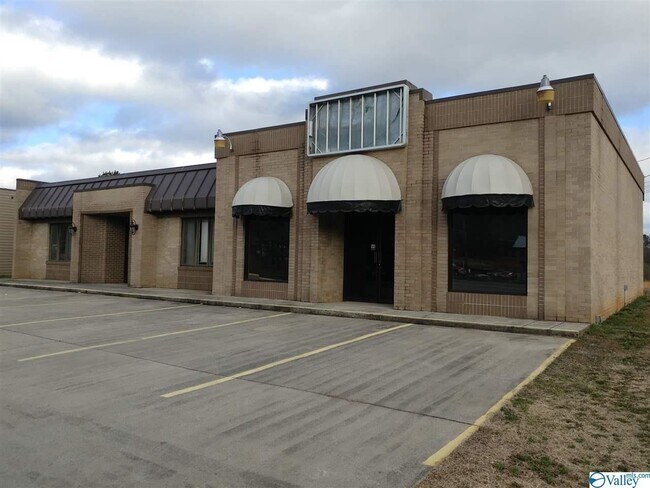
Property Record
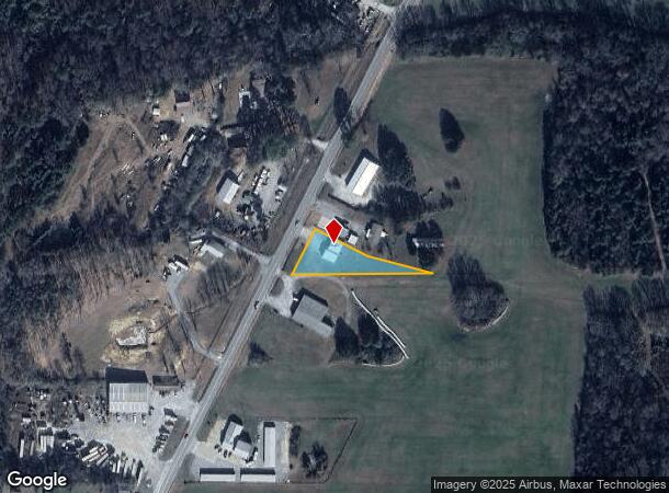
1231 Highway Seventy Seven, Attalla, AL 35954
NEARBY LISTINGS FOR SALE OR LEASE
Property Detail
1231 Highway Seventy Seven
16-02-04-0-001-036.004
H/S BASE YEAR LT 146.62 X 177.40 X 200.14 X 417.44 LYING IN SW1/4 SE1/4 4-12-5 1542-71,1553-297,1671-129,T/S 1999-59(RED 12-2
Officebuilding
Etowah
AE
Alabama
01055C0188E
0.67 AC
2025
Etowah County
2025
Birmingham
010300
Gadsden, AL
1,448 SF
DEMOGRAPHICS near 1231 Highway Seventy Seven
1 Mile
3 Mile
5 Mile
2024 Total Population
1,366
8,049
17,984
2029 Population
1,373
8,049
18,005
Pop Growth 2024-2029
+ 0.51%
0.00%
+ 0.12%
Average Age
39
41
40
2024 Total Households
537
3,266
7,302
HH Growth 2024-2029
+ 0.56%
(0.03%)
+ 0.12%
Median Household Inc
$47,054
$43,981
$38,709
Avg Household Size
2.40
2.40
2.40
2024 Avg HH Vehicles
2.00
2.00
2.00
Median Home Value
$110,191
$104,943
$84,999
Median Year Built
1968
1967
1963
Nearby Places
Map Layers
Map Styles
 Street
 Aerial
- Restaurants
- Banks
- Shops
- Fitness
- Groceries
SALE & LEASE HISTORY
LISTING DATE
SALE/LEASE

Apr 08, 2020
For Sale
Apr 08, 2020
For Lease
Nearby Properties
Address
Land Use
TOTAL SIZE
Lot Size
Zoning
Address
Land Use
TOTAL SIZE
Lot Size
Zoning
6,000 SF
87.16 AC
Address
Land Use
TOTAL SIZE
Lot Size
Zoning
191,168 SF
Address
Land Use
TOTAL SIZE
Lot Size
Zoning
37,366 SF
17.80 AC
Address
Land Use
TOTAL SIZE
Lot Size
Zoning
7,500 SF
44 AC
Address
Land Use
TOTAL SIZE
Lot Size
Zoning
315,368 SF
9.20 AC
Address
Land Use
TOTAL SIZE
Lot Size
Zoning
238,620 SF
11.76 AC
Address
Land Use
TOTAL SIZE
Lot Size
Zoning
153,802 SF
19.47 AC
Address
Land Use
TOTAL SIZE
Lot Size
Zoning
262,140 SF
30 AC
Address
Land Use
TOTAL SIZE
Lot Size
Zoning
72,595 SF
3.40 AC
Address
Land Use
TOTAL SIZE
Lot Size
Zoning
51,088 SF
1.81 AC
Address
Land Use
TOTAL SIZE
Lot Size
Zoning
39,536 SF
7.08 AC
Address
Land Use
TOTAL SIZE
Lot Size
Zoning
43,027 SF
22.88 AC
Address
Land Use
TOTAL SIZE
Lot Size
Zoning
43,279 SF
1.79 AC
Address
Land Use
TOTAL SIZE
Lot Size
Zoning
70,075 SF
5.60 AC
Address
Land Use
TOTAL SIZE
Lot Size
Zoning
50,316 SF
1.94 AC
Address
Land Use
TOTAL SIZE
Lot Size
Zoning
13,600 SF
28 AC
Address
Land Use
TOTAL SIZE
Lot Size
Zoning
51,822 SF
1.81 AC
Address
Land Use
TOTAL SIZE
Lot Size
Zoning
38,070 SF
1.86 AC
Address
Land Use
TOTAL SIZE
Lot Size
Zoning
223,400 SF
25 AC
Address
Land Use
TOTAL SIZE
Lot Size
Zoning
54,296 SF
8.95 AC
Address
Land Use
TOTAL SIZE
Lot Size
Zoning
6,000 SF
5.20 AC
Address
Land Use
TOTAL SIZE
Lot Size
Zoning
58,718 SF
5.10 AC
Address
Land Use
TOTAL SIZE
Lot Size
Zoning
60,389 SF
3.33 AC
Address
Land Use
TOTAL SIZE
Lot Size
Zoning
45,371 SF
5.60 AC
Address
Land Use
TOTAL SIZE
Lot Size
Zoning
2,800 SF
2.98 AC
Address
Land Use
TOTAL SIZE
Lot Size
Zoning
12,500 SF
1.27 AC
Address
Land Use
TOTAL SIZE
Lot Size
Zoning
9,824 SF
19.41 AC
Address
Land Use
TOTAL SIZE
Lot Size
Zoning
58,728 SF
10.30 AC
Address
Land Use
TOTAL SIZE
Lot Size
Zoning
61,924 SF
9.40 AC
Address
Land Use
TOTAL SIZE
Lot Size
Zoning
4,440 SF
10 AC
The World's #1 Commercial Real Estate Marketplace
Connect with us
© 2025 CoStar Group
The information above has been obtained from sources believed reliable. While we do not doubt its accuracy we have not verified it and make no guarantee, warranty or representation about it. It is your responsibility to independently confirm its accuracy and completeness. Any projections, opinions, assumptions, or estimates used are for example only and do not represent the current or future performance of the property. The value of this transaction to you depends on tax and other factors which should be evaluated by your tax, financial, and legal advisors. You and your advisors should conduct a careful, independent investigation of the property to determine to your satisfaction the suitability of the property for your needs.