Property Record
12310 Highway 48, Menlo, GA 30731

NEARBY LISTINGS FOR SALE OR LEASE
-
-
View all Menlo listings for sale on LoopNet.com
Property Detail
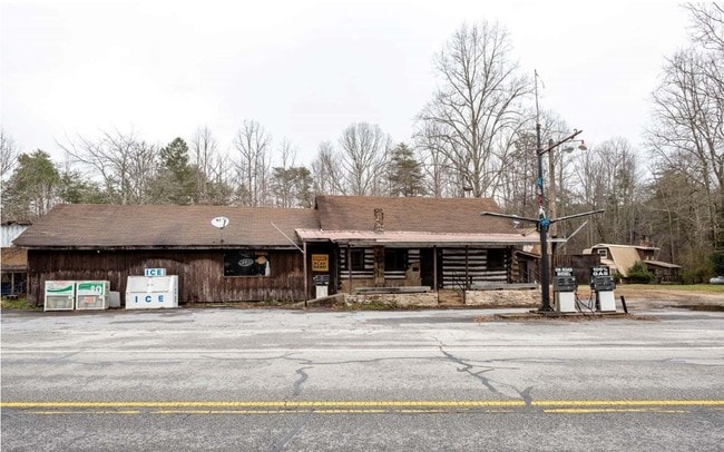
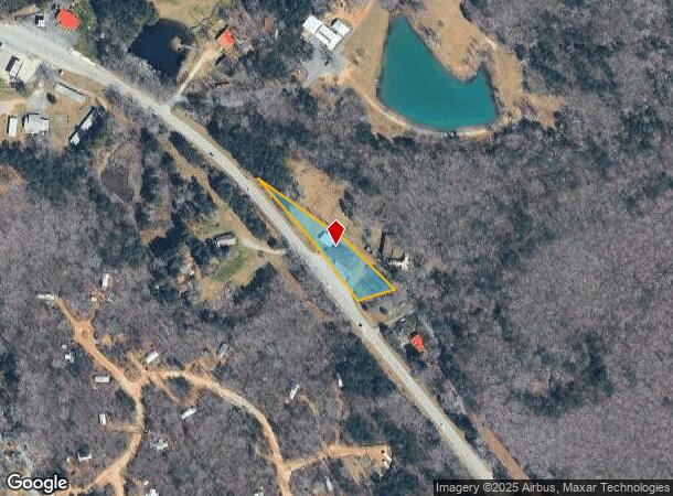
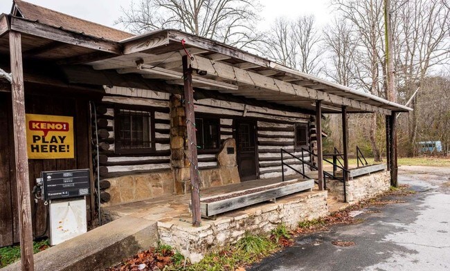
12310 Highway 48
00003-00000-006-000 01
Ac: 15000
Conveniencestore
1 AC MORE OR LESS B/F JOH LANDDIST: 13
X
Chattooga
01049C0220E
Georgia
2024
0.64 AC
2024
Georgia Northwest
010300
Other Market Areas
3,300 SF
Summerville, GA
DEMOGRAPHICS near 12310 Highway 48
1 Mile
3 Mile
5 Mile
2024 Total Population
212
1,331
3,333
2029 Population
219
1,371
3,381
Pop Growth 2024-2029
+ 3.30%
+ 3.01%
+ 1.44%
Average Age
48
47
46
2024 Total Households
96
587
1,452
HH Growth 2024-2029
+ 3.13%
+ 3.07%
+ 1.52%
Median Household Inc
$33,928
$34,715
$35,840
Avg Household Size
2.20
2.20
2.30
2024 Avg HH Vehicles
2.00
2.00
2.00
Median Home Value
$184,999
$173,931
$140,370
Median Year Built
1990
1990
1986
Nearby Places
Map Layers
Map Styles
 Street
 Aerial
- Restaurants
- Banks
- Shops
- Fitness
- Groceries
SALE & LEASE HISTORY
LISTING DATE
SALE/LEASE

Feb 26, 2019
For Sale
Nearby Properties
Address
Land Use
TOTAL SIZE
Lot Size
Zoning
Address
Land Use
TOTAL SIZE
Lot Size
Zoning
641 AC
Address
Land Use
TOTAL SIZE
Lot Size
Zoning
36,772 SF
14.50 AC
Address
Land Use
TOTAL SIZE
Lot Size
Zoning
2,760 SF
0.66 AC
Address
Land Use
TOTAL SIZE
Lot Size
Zoning
246 AC
Address
Land Use
TOTAL SIZE
Lot Size
Zoning
331.33 AC
Address
Land Use
TOTAL SIZE
Lot Size
Zoning
412.06 AC
Address
Land Use
TOTAL SIZE
Lot Size
Zoning
137 AC
Address
Land Use
TOTAL SIZE
Lot Size
Zoning
228 AC
Address
Land Use
TOTAL SIZE
Lot Size
Zoning
4,504 SF
2.41 AC
Address
Land Use
TOTAL SIZE
Lot Size
Zoning
189.95 AC
Address
Land Use
TOTAL SIZE
Lot Size
Zoning
1,500 SF
1.25 AC
Address
Land Use
TOTAL SIZE
Lot Size
Zoning
1,090 SF
49.23 AC
Address
Land Use
TOTAL SIZE
Lot Size
Zoning
161 AC
Address
Land Use
TOTAL SIZE
Lot Size
Zoning
115.38 AC
Address
Land Use
TOTAL SIZE
Lot Size
Zoning
1,800 SF
1 AC
Address
Land Use
TOTAL SIZE
Lot Size
Zoning
51.21 AC
Address
Land Use
TOTAL SIZE
Lot Size
Zoning
1,288 SF
93.60 AC
Address
Land Use
TOTAL SIZE
Lot Size
Zoning
106.93 AC
Address
Land Use
TOTAL SIZE
Lot Size
Zoning
162.47 AC
Address
Land Use
TOTAL SIZE
Lot Size
Zoning
89.95 AC
Address
Land Use
TOTAL SIZE
Lot Size
Zoning
990 SF
5 AC
Address
Land Use
TOTAL SIZE
Lot Size
Zoning
79.28 AC
Address
Land Use
TOTAL SIZE
Lot Size
Zoning
91.45 AC
Address
Land Use
TOTAL SIZE
Lot Size
Zoning
56.36 AC
Address
Land Use
TOTAL SIZE
Lot Size
Zoning
2,000 SF
5 AC
Address
Land Use
TOTAL SIZE
Lot Size
Zoning
3,496 SF
46.50 AC
Address
Land Use
TOTAL SIZE
Lot Size
Zoning
66.23 AC
Address
Land Use
TOTAL SIZE
Lot Size
Zoning
48.10 AC
Address
Land Use
TOTAL SIZE
Lot Size
Zoning
93.42 AC
The World's #1 Commercial Real Estate Marketplace
Connect with us
© 2026 CoStar Group
The information above has been obtained from sources believed reliable. While we do not doubt its accuracy we have not verified it and make no guarantee, warranty or representation about it. It is your responsibility to independently confirm its accuracy and completeness. Any projections, opinions, assumptions, or estimates used are for example only and do not represent the current or future performance of the property. The value of this transaction to you depends on tax and other factors which should be evaluated by your tax, financial, and legal advisors. You and your advisors should conduct a careful, independent investigation of the property to determine to your satisfaction the suitability of the property for your needs.