Property Record
1232 1St St, Sutherland, NE 69165
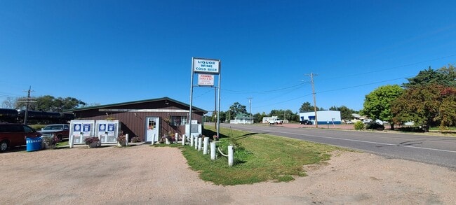


This Property Is For Sale
Property Detail
1232 1St St
0090490.00
CO. CLERK'S SUB. (PT. W1/2 29-14-33) PT. E. 242.85' OF LOT 5; MAP NUMBER: 2871-00-0-00000-000-0490
Conveniencestore
LINCOLN
COMMERCIAL
Nebraska
B and X Area of moderate flood hazard, usually the area between the limits of the 100-year and 500-year floods.
5
2025
0.23 AC
2025
I-80 Corridor
959800
Other Market Areas
1,280 SF
North Platte, NE
NEARBY LISTINGS FOR SALE OR LEASE
-
-
View all Sutherland listings for sale on LoopNet.com
DEMOGRAPHICS near 1232 1St St
1 mile
3 mile
5 mile
2025 Total Population
1,272
1,398
1,540
2030 Population
1,239
1,363
1,503
Pop Growth 2025-2030
(2.59%)
(2.50%)
(2.40%)
Average Age
43
43
43
2025 Total Households
500
550
606
HH Growth 2025-2030
(2.80%)
(2.73%)
(2.64%)
Median Household Inc
$88,181
$87,916
$88,419
Avg Household Size
2.40
2.40
2.40
2025 Avg HH Vehicles
3.00
3.00
3.00
Median Home Value
$245,769
$246,180
$245,541
Median Year Built
1971
1971
1971
Nearby Places
Map Layers
Map Styles
 Street
 Aerial
Transit
 Traffic
 Biking
Places
Listings with unknown addresses are not visible on the map
- Restaurants
- Banks
- Shops
- Fitness
- Groceries
Nearby Properties
Address
Land Use
TOTAL SIZE
Lot Size
Zoning
Address
Land Use
TOTAL SIZE
Lot Size
Zoning
10 SF
5.30 AC
INDUSTRIAL
Address
Land Use
TOTAL SIZE
Lot Size
Zoning
18,450 SF
4.45 AC
INDUSTRIAL
Address
Land Use
TOTAL SIZE
Lot Size
Zoning
4,800 SF
61.81 AC
INDUSTRIAL
Address
Land Use
TOTAL SIZE
Lot Size
Zoning
21,265 SF
604.41 AC
AGRICULTUR
Address
Land Use
TOTAL SIZE
Lot Size
Zoning
27,834 SF
158.65 AC
AGRICULTUR
Address
Land Use
TOTAL SIZE
Lot Size
Zoning
9,100 SF
0.94 AC
COMMERCIAL
Address
Land Use
TOTAL SIZE
Lot Size
Zoning
130.50 AC
AGRICULTUR
Address
Land Use
TOTAL SIZE
Lot Size
Zoning
135.50 AC
AGRICULTUR
Address
Land Use
TOTAL SIZE
Lot Size
Zoning
399.58 AC
AGRICULTUR
Address
Land Use
TOTAL SIZE
Lot Size
Zoning
10,000 SF
35.96 AC
COMMERCIAL
Address
Land Use
TOTAL SIZE
Lot Size
Zoning
11,956 SF
0.48 AC
COMMERCIAL
Address
Land Use
TOTAL SIZE
Lot Size
Zoning
10,572 SF
0.88 AC
COMMERCIAL
Address
Land Use
TOTAL SIZE
Lot Size
Zoning
7,576 SF
8.36 AC
COMMERCIAL
Address
Land Use
TOTAL SIZE
Lot Size
Zoning
6,000 SF
2.44 AC
COMMERCIAL
Address
Land Use
TOTAL SIZE
Lot Size
Zoning
4,200 SF
0.63 AC
COMMERCIAL
Address
Land Use
TOTAL SIZE
Lot Size
Zoning
1,541 SF
158 AC
COMMERCIAL
Address
Land Use
TOTAL SIZE
Lot Size
Zoning
107.86 AC
AGRICULTUR
Address
Land Use
TOTAL SIZE
Lot Size
Zoning
3,008 SF
1.25 AC
COMMERCIAL
Address
Land Use
TOTAL SIZE
Lot Size
Zoning
236.38 AC
AGRICULTUR
Address
Land Use
TOTAL SIZE
Lot Size
Zoning
1,620 SF
0.49 AC
COMMERCIAL
Address
Land Use
TOTAL SIZE
Lot Size
Zoning
4,216 SF
0.48 AC
COMMERCIAL
Address
Land Use
TOTAL SIZE
Lot Size
Zoning
26,720 SF
41.08 AC
SINGLE-FAM
Address
Land Use
TOTAL SIZE
Lot Size
Zoning
2,400 SF
2.01 AC
COMMERCIAL
Address
Land Use
TOTAL SIZE
Lot Size
Zoning
7,774 SF
2.04 AC
COMMERCIAL
Address
Land Use
TOTAL SIZE
Lot Size
Zoning
23,225 SF
0.48 AC
COMMERCIAL
Address
Land Use
TOTAL SIZE
Lot Size
Zoning
45.12 AC
AGRICULTUR
Address
Land Use
TOTAL SIZE
Lot Size
Zoning
672 SF
5.93 AC
COMMERCIAL
Address
Land Use
TOTAL SIZE
Lot Size
Zoning
1,626 SF
0.87 AC
SINGLE-FAM
Address
Land Use
TOTAL SIZE
Lot Size
Zoning
3,328 SF
0.19 AC
MULTI-FAMI
Address
Land Use
TOTAL SIZE
Lot Size
Zoning
4,154 SF
0.48 AC
COMMERCIAL
The World's #1 Commercial Real Estate Marketplace
Connect with us
© 2026 CoStar Group
The information above has been obtained from sources believed reliable. While we do not doubt its accuracy we have not verified it and make no guarantee, warranty or representation about it. It is your responsibility to independently confirm its accuracy and completeness. Any projections, opinions, assumptions, or estimates used are for example only and do not represent the current or future performance of the property. The value of this transaction to you depends on tax and other factors which should be evaluated by your tax, financial, and legal advisors. You and your advisors should conduct a careful, independent investigation of the property to determine to your satisfaction the suitability of the property for your needs.