Property Record
1232 E Hudson Blvd, Gastonia, NC 28054
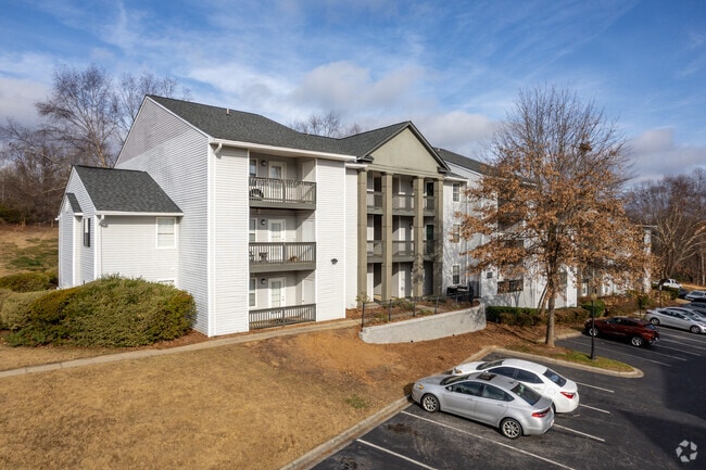

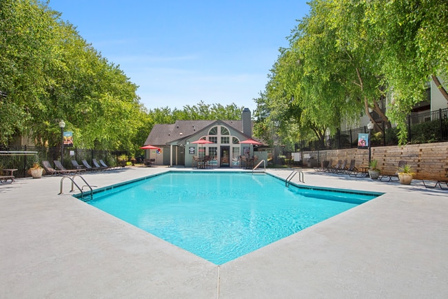
Property Detail
1232 E Hudson Blvd
224088
10 054 001 07 000
Apartment
Gaston
AE The base floodplain where base flood elevations are provided. AE Zones are now used on new format FIRMs instead of A1-A30 Zones.
North Carolina
2025
16.10 AC
2025
Outlying Gaston County
032702
Charlotte
2,066 SF
Charlotte-Concord-Gastonia, NC-SC
NEARBY LISTINGS FOR SALE OR LEASE
-
-
View all Gastonia listings for sale on LoopNet.com
DEMOGRAPHICS near 1232 E Hudson Blvd
1 mile
3 mile
5 mile
2025 Total Population
7,868
58,946
112,049
2030 Population
8,184
61,682
117,748
Pop Growth 2025-2030
+ 4.02%
+ 4.64%
+ 5.09%
Average Age
42
40
40
2025 Total Households
3,580
23,900
44,482
HH Growth 2025-2030
+ 4.16%
+ 4.80%
+ 5.26%
Median Household Inc
$56,465
$62,449
$65,478
Avg Household Size
2.10
2.30
2.40
2025 Avg HH Vehicles
1.00
2.00
2.00
Median Home Value
$260,225
$274,032
$271,174
Median Year Built
1982
1977
1979
Nearby Places
Map Layers
Map Styles
 Street
 Aerial
Layers
 Traffic
 Biking
Places
Listings with unknown addresses are not visible on the map
- Restaurants
- Banks
- Shops
- Fitness
- Groceries
PUBLIC TRANSPORTATION
COMMUTER RAIL
Gastonia Amtrak Station (Crescent - Amtrak)
Drive
Walk
Distance
Gastonia Amtrak Station (Crescent - Amtrak)
7 min
3.8 mi
AIRPORT
Charlotte/Douglas International
Drive
Walk
Distance
Charlotte/Douglas International
31 min
17.0 mi
Concord-Padgett Regional
Drive
Walk
Distance
Concord-Padgett Regional
46 min
33.4 mi
Freight Ports
North Charleston Terminal
Drive
Walk
Distance
North Charleston Terminal
239 min
202.1 mi
Nearby Properties
Address
Land Use
TOTAL SIZE
Lot Size
Zoning
Address
Land Use
TOTAL SIZE
Lot Size
Zoning
56,000 SF
23.22 AC
GOV01
Address
Land Use
TOTAL SIZE
Lot Size
Zoning
4,519 SF
2.10 AC
Address
Land Use
TOTAL SIZE
Lot Size
Zoning
3,026 SF
32.14 AC
HCAR3
Address
Land Use
TOTAL SIZE
Lot Size
Zoning
7,880 SF
18.35 AC
R1
Address
Land Use
TOTAL SIZE
Lot Size
Zoning
159,263 SF
9.83 AC
GOV01
Address
Land Use
TOTAL SIZE
Lot Size
Zoning
Address
Land Use
TOTAL SIZE
Lot Size
Zoning
5,200 SF
22.98 AC
OFF01
Address
Land Use
TOTAL SIZE
Lot Size
Zoning
8,040 SF
18.44 AC
APT01
Address
Land Use
TOTAL SIZE
Lot Size
Zoning
3,120 SF
15.05 AC
OFF01
Address
Land Use
TOTAL SIZE
Lot Size
Zoning
1,886 SF
13.27 AC
APT01
Address
Land Use
TOTAL SIZE
Lot Size
Zoning
1,974 SF
15.50 AC
APT01
Address
Land Use
TOTAL SIZE
Lot Size
Zoning
1,602 SF
14.02 AC
APT02
Address
Land Use
TOTAL SIZE
Lot Size
Zoning
9,792 SF
14.31 AC
APT01
Address
Land Use
TOTAL SIZE
Lot Size
Zoning
8,960 SF
12.67 AC
Address
Land Use
TOTAL SIZE
Lot Size
Zoning
103,890 SF
8.81 AC
OFF04
Address
Land Use
TOTAL SIZE
Lot Size
Zoning
4,568 SF
24.69 AC
PUB01
Address
Land Use
TOTAL SIZE
Lot Size
Zoning
1,680 SF
19.08 AC
OFF01
Address
Land Use
TOTAL SIZE
Lot Size
Zoning
Address
Land Use
TOTAL SIZE
Lot Size
Zoning
1,868 SF
15.93 AC
OFF01
Address
Land Use
TOTAL SIZE
Lot Size
Zoning
5,120 SF
9.42 AC
Address
Land Use
TOTAL SIZE
Lot Size
Zoning
18,803 SF
9.57 AC
SHOP3
Address
Land Use
TOTAL SIZE
Lot Size
Zoning
33,258 SF
5.51 AC
Address
Land Use
TOTAL SIZE
Lot Size
Zoning
198,897 SF
10.89 AC
RET05
Address
Land Use
TOTAL SIZE
Lot Size
Zoning
1,170 SF
320.29 AC
OFF01
Address
Land Use
TOTAL SIZE
Lot Size
Zoning
22.85 AC
Address
Land Use
TOTAL SIZE
Lot Size
Zoning
6,774 SF
13.86 AC
APT02
Address
Land Use
TOTAL SIZE
Lot Size
Zoning
123,948 SF
6.94 AC
GOV05
Address
Land Use
TOTAL SIZE
Lot Size
Zoning
0.79 AC
RET01
Address
Land Use
TOTAL SIZE
Lot Size
Zoning
135,840 SF
11.21 AC
The World's #1 Commercial Real Estate Marketplace
Connect with us
© 2026 CoStar Group
The information above has been obtained from sources believed reliable. While we do not doubt its accuracy we have not verified it and make no guarantee, warranty or representation about it. It is your responsibility to independently confirm its accuracy and completeness. Any projections, opinions, assumptions, or estimates used are for example only and do not represent the current or future performance of the property. The value of this transaction to you depends on tax and other factors which should be evaluated by your tax, financial, and legal advisors. You and your advisors should conduct a careful, independent investigation of the property to determine to your satisfaction the suitability of the property for your needs.