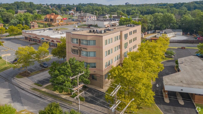
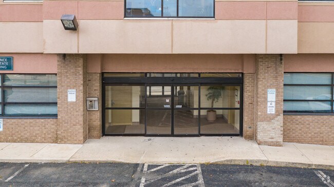
Property Record
1232 Race Rd, Rosedale, MD 21237
NEARBY LISTINGS FOR SALE OR LEASE
Property Detail
1232 Race Rd
Baltimore-Columbia-Towson, MD
Rossville Med Ctr Condo
15-2200008357
UNIT 303 PHASE 3 ROSSVILLE MED CTR COND
Commercialnec
Baltimore
X
Maryland
2400100430H
1356
2024
0.03 AC
2025
Baltimore County East
451200
Baltimore
1,300 SF
DEMOGRAPHICS near 1232 Race Rd
1 Mile
3 Mile
5 Mile
2024 Total Population
8,376
101,580
294,632
2029 Population
8,248
99,873
286,841
Pop Growth 2024-2029
(1.53%)
(1.68%)
(2.64%)
Average Age
38
40
40
2024 Total Households
3,289
38,908
115,219
HH Growth 2024-2029
(1.61%)
(1.80%)
(2.78%)
Median Household Inc
$69,269
$68,498
$68,623
Avg Household Size
2.40
2.50
2.50
2024 Avg HH Vehicles
2.00
2.00
2.00
Median Home Value
$281,995
$236,643
$231,261
Median Year Built
1983
1967
1962
Nearby Places
- Restaurants
- Banks
- Shops
- Fitness
- Groceries
PUBLIC TRANSPORTATION
COMMUTER RAIL
Martin State Airport (PENN - WASHINGTON - Maryland Area Regional Commuter Trains (The MARC), Penn Line - Maryland Area Regional Commuter Trains (The MARC))
DRIVE
WALK
Distance
Martin State Airport (PENN - WASHINGTON - Maryland Area Regional Commuter Trains (The MARC), Penn Line - Maryland Area Regional Commuter Trains (The MARC))
8 min
4.2 mi
Penn Station (PENN - WASHINGTON - Maryland Area Regional Commuter Trains (The MARC), Penn Line - Maryland Area Regional Commuter Trains (The MARC), Penn Station & Camden Yards - Maryland Area Regional Commuter Trains (The MARC))
DRIVE
WALK
Distance
Penn Station (PENN - WASHINGTON - Maryland Area Regional Commuter Trains (The MARC), Penn Line - Maryland Area Regional Commuter Trains (The MARC), Penn Station & Camden Yards - Maryland Area Regional Commuter Trains (The MARC))
20 min
9.0 mi
AIRPORT
Baltimore/Washington International Thurgood Marshall
DRIVE
WALK
Distance
Baltimore/Washington International Thurgood Marshall
32 min
20.2 mi
Freight Ports
Port of Baltimore
DRIVE
WALK
Distance
Port of Baltimore
18 min
10.6 mi
SALE & LEASE HISTORY
LISTING DATE
SALE/LEASE

Nov 02, 2022
For Sale
May 25, 2018
For Sale
Mar 08, 2018
For Sale
Jun 13, 2019
For Sale
Jul 03, 2019
For Lease
Jul 01, 2019
For Sale
Jan 10, 2018
For Sale
Apr 10, 2018
For Sale
Apr 09, 2018
For Lease
Apr 09, 2018
For Sale
Nearby Properties
Address
Land Use
TOTAL SIZE
Lot Size
Zoning
Address
Land Use
TOTAL SIZE
Lot Size
Zoning
1,877,670 SF
90.21 AC
Address
Land Use
TOTAL SIZE
Lot Size
Zoning
307,785 SF
30.50 AC
ML
Address
Land Use
TOTAL SIZE
Lot Size
Zoning
119,200 SF
57.12 AC
Address
Land Use
TOTAL SIZE
Lot Size
Zoning
527,364 SF
18.11 AC
BM
Address
Land Use
TOTAL SIZE
Lot Size
Zoning
46.20 AC
DR105
Address
Land Use
TOTAL SIZE
Lot Size
Zoning
474,640 SF
12.42 AC
Address
Land Use
TOTAL SIZE
Lot Size
Zoning
560,700 SF
25.77 AC
Address
Land Use
TOTAL SIZE
Lot Size
Zoning
85,474 SF
22.22 AC
Address
Land Use
TOTAL SIZE
Lot Size
Zoning
21.74 AC
DR16
Address
Land Use
TOTAL SIZE
Lot Size
Zoning
15.29 AC
Address
Land Use
TOTAL SIZE
Lot Size
Zoning
101,906 SF
13.54 AC
Address
Land Use
TOTAL SIZE
Lot Size
Zoning
105,384 SF
11.52 AC
Address
Land Use
TOTAL SIZE
Lot Size
Zoning
12.20 AC
DR16
Address
Land Use
TOTAL SIZE
Lot Size
Zoning
1,062,672 SF
70.27 AC
MHIM
Address
Land Use
TOTAL SIZE
Lot Size
Zoning
9.27 AC
DR105
Address
Land Use
TOTAL SIZE
Lot Size
Zoning
15.40 AC
DR16
Address
Land Use
TOTAL SIZE
Lot Size
Zoning
427,720 SF
27.55 AC
ML
Address
Land Use
TOTAL SIZE
Lot Size
Zoning
507,600 SF
21.36 AC
MHIM
Address
Land Use
TOTAL SIZE
Lot Size
Zoning
105,384 SF
15.41 AC
Address
Land Use
TOTAL SIZE
Lot Size
Zoning
718,098 SF
83.20 AC
MH-IM
Address
Land Use
TOTAL SIZE
Lot Size
Zoning
14.28 AC
DR16
Address
Land Use
TOTAL SIZE
Lot Size
Zoning
271,370 SF
20.11 AC
BM
Address
Land Use
TOTAL SIZE
Lot Size
Zoning
117,170 SF
7.84 AC
BM
Address
Land Use
TOTAL SIZE
Lot Size
Zoning
253,081 SF
42.21 AC
DR5.5
Address
Land Use
TOTAL SIZE
Lot Size
Zoning
300,400 SF
31.60 AC
ML-IM
Address
Land Use
TOTAL SIZE
Lot Size
Zoning
135,931 SF
21.65 AC
DR5.5
Address
Land Use
TOTAL SIZE
Lot Size
Zoning
192 SF
11.09 AC
Address
Land Use
TOTAL SIZE
Lot Size
Zoning
97,878 SF
12.45 AC
DR5.5
Address
Land Use
TOTAL SIZE
Lot Size
Zoning
158,131 SF
13.02 AC
BM
Address
Land Use
TOTAL SIZE
Lot Size
Zoning
20.13 AC
DR16
The World's #1 Commercial Real Estate Marketplace
Connect with us
© 2025 CoStar Group
The information above has been obtained from sources believed reliable. While we do not doubt its accuracy we have not verified it and make no guarantee, warranty or representation about it. It is your responsibility to independently confirm its accuracy and completeness. Any projections, opinions, assumptions, or estimates used are for example only and do not represent the current or future performance of the property. The value of this transaction to you depends on tax and other factors which should be evaluated by your tax, financial, and legal advisors. You and your advisors should conduct a careful, independent investigation of the property to determine to your satisfaction the suitability of the property for your needs.