Property Record
12320 Oracle Blvd, Colorado Springs, CO 80921

Current Lease Availabilities
NEARBY LISTINGS FOR SALE OR LEASE
Property Detail
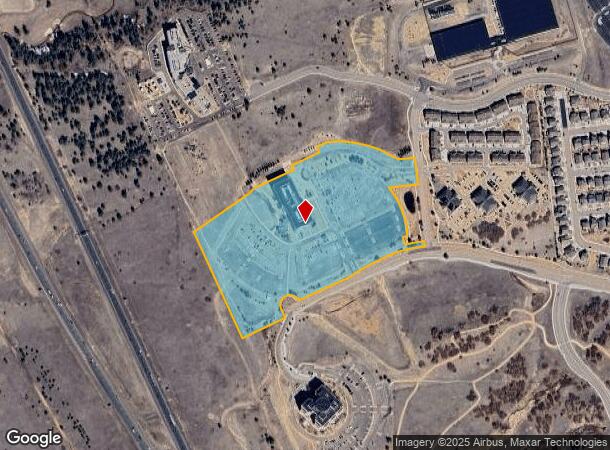
12320 Oracle Blvd
Colorado Springs, CO
Oracle Colorado Campus Sub No 1
62181-01-004
LOT 1 ORACLE COLORADO CAMPUS SUB NO 1, AS AMENDED BY BOUNDARY LINE ADJUSTMENT REC #224025971
Officebuilding
El Paso
X
Colorado
08041C0290G
1
2024
20.99 AC
2025
Northeast
007205
Colorado Springs
181,852 SF
DEMOGRAPHICS near 12320 Oracle Blvd
1 Mile
3 Mile
5 Mile
2024 Total Population
4,087
26,022
69,392
2029 Population
4,339
27,451
73,362
Pop Growth 2024-2029
+ 6.17%
+ 5.49%
+ 5.72%
Average Age
35
39
39
2024 Total Households
1,571
9,365
24,405
HH Growth 2024-2029
+ 6.30%
+ 5.73%
+ 6.01%
Median Household Inc
$113,082
$128,246
$125,780
Avg Household Size
2.60
2.80
2.80
2024 Avg HH Vehicles
2.00
2.00
2.00
Median Home Value
$615,795
$608,495
$586,820
Median Year Built
2010
2007
2003
Nearby Places
Map Layers
Map Styles
 Street
 Aerial
- Restaurants
- Banks
- Shops
- Fitness
- Groceries
PUBLIC TRANSPORTATION
AIRPORT
City of Colorado Springs Municipal
DRIVE
WALK
Distance
City of Colorado Springs Municipal
31 min
18.9 mi
Freight Ports
Tulsa Port Of Catoosa
DRIVE
WALK
Distance
Tulsa Port Of Catoosa
739 min
694.0 mi
Nearby Properties
Address
Land Use
TOTAL SIZE
Lot Size
Zoning
Address
Land Use
TOTAL SIZE
Lot Size
Zoning
177,966 SF
57.81 AC
PDZ HR
Address
Land Use
TOTAL SIZE
Lot Size
Zoning
261,339 SF
10.42 AC
MX-M CU
Address
Land Use
TOTAL SIZE
Lot Size
Zoning
278,951 SF
32.43 AC
BP/CR HR
Address
Land Use
TOTAL SIZE
Lot Size
Zoning
257,140 SF
30.17 AC
MX-N/CR MX
Address
Land Use
TOTAL SIZE
Lot Size
Zoning
121,820 SF
14.73 AC
BP
Address
Land Use
TOTAL SIZE
Lot Size
Zoning
95,337 SF
49.29 AC
BP
Address
Land Use
TOTAL SIZE
Lot Size
Zoning
562,942 SF
27.13 AC
PDZ
Address
Land Use
TOTAL SIZE
Lot Size
Zoning
56,290 SF
6.55 AC
A/CR
Address
Land Use
TOTAL SIZE
Lot Size
Zoning
112,266 SF
0.24 AC
RR3
Address
Land Use
TOTAL SIZE
Lot Size
Zoning
316,105 SF
19.73 AC
PDZ
Address
Land Use
TOTAL SIZE
Lot Size
Zoning
323,646 SF
31.30 AC
A BP/CR BP
Address
Land Use
TOTAL SIZE
Lot Size
Zoning
391,914 SF
3.13 AC
PDZ
Address
Land Use
TOTAL SIZE
Lot Size
Zoning
211,974 SF
25.15 AC
BP CU
Address
Land Use
TOTAL SIZE
Lot Size
Zoning
68,829 SF
6 AC
BP/CR
Address
Land Use
TOTAL SIZE
Lot Size
Zoning
188,626 SF
22.34 AC
BP/CR HR
Address
Land Use
TOTAL SIZE
Lot Size
Zoning
151,287 SF
9.40 AC
PDZ HR
Address
Land Use
TOTAL SIZE
Lot Size
Zoning
154,703 SF
14.29 AC
BP HR
Address
Land Use
TOTAL SIZE
Lot Size
Zoning
411,465 SF
22.54 AC
PDZ
Address
Land Use
TOTAL SIZE
Lot Size
Zoning
322,150 SF
19 AC
PDZ HR
Address
Land Use
TOTAL SIZE
Lot Size
Zoning
355,799 SF
10.51 AC
PDZ HR
Address
Land Use
TOTAL SIZE
Lot Size
Zoning
109,437 SF
1.08 AC
PDZ
Address
Land Use
TOTAL SIZE
Lot Size
Zoning
132,854 SF
10 AC
BP/CR HR
Address
Land Use
TOTAL SIZE
Lot Size
Zoning
600 SF
25.36 AC
A
Address
Land Use
TOTAL SIZE
Lot Size
Zoning
20,752 SF
1.27 AC
BP HR
Address
Land Use
TOTAL SIZE
Lot Size
Zoning
82,671 SF
21.90 AC
PDZ
Address
Land Use
TOTAL SIZE
Lot Size
Zoning
154,816 SF
17.75 AC
BP HR
Address
Land Use
TOTAL SIZE
Lot Size
Zoning
346,674 SF
17.96 AC
PDZ
Address
Land Use
TOTAL SIZE
Lot Size
Zoning
349,673 SF
12.25 AC
PDZ
Address
Land Use
TOTAL SIZE
Lot Size
Zoning
144,340 SF
17.01 AC
BP HR
The World's #1 Commercial Real Estate Marketplace
Connect with us
© 2025 CoStar Group
The information above has been obtained from sources believed reliable. While we do not doubt its accuracy we have not verified it and make no guarantee, warranty or representation about it. It is your responsibility to independently confirm its accuracy and completeness. Any projections, opinions, assumptions, or estimates used are for example only and do not represent the current or future performance of the property. The value of this transaction to you depends on tax and other factors which should be evaluated by your tax, financial, and legal advisors. You and your advisors should conduct a careful, independent investigation of the property to determine to your satisfaction the suitability of the property for your needs.