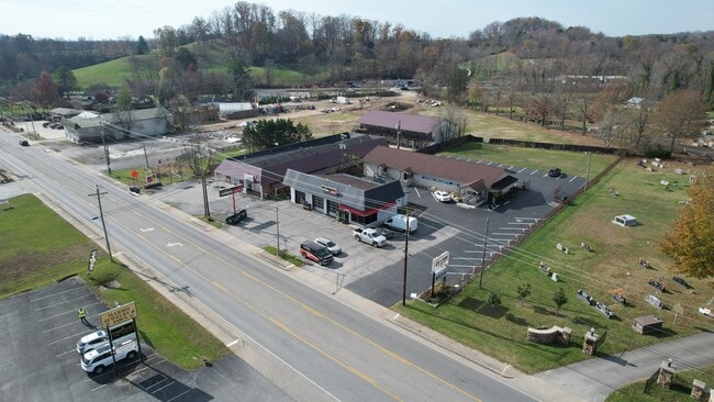
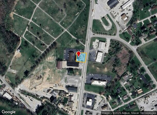
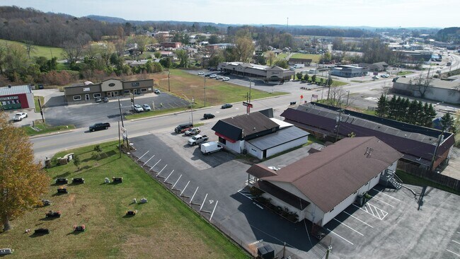
Property Record
1233 S Main St, London, KY 40741
NEARBY LISTINGS FOR SALE OR LEASE
Property Detail
1233 S Main St
063-10-00-029.00
0.23 ACRE & SAFELITE AUTO GLASS BUILDING
Storebuilding
Laurel
X
Kentucky
21125C0230D
0.23 AC
2025
Corbin/London Area
2025
Other Market Areas
970600
London, KY
DEMOGRAPHICS near 1233 S Main St
1 Mile
3 Mile
5 Mile
2024 Total Population
3,163
15,175
28,095
2029 Population
3,246
15,442
28,605
Pop Growth 2024-2029
+ 2.62%
+ 1.76%
+ 1.82%
Average Age
42
41
40
2024 Total Households
1,402
6,230
10,995
HH Growth 2024-2029
+ 2.64%
+ 1.72%
+ 1.78%
Median Household Inc
$41,785
$48,345
$49,422
Avg Household Size
2.10
2.30
2.40
2024 Avg HH Vehicles
2.00
2.00
2.00
Median Home Value
$163,867
$162,944
$154,410
Median Year Built
1976
1985
1989
Nearby Places
Map Layers
Map Styles
 Street
 Aerial
- Restaurants
- Banks
- Shops
- Fitness
- Groceries
Nearby Properties
Address
Land Use
TOTAL SIZE
Lot Size
Zoning
Address
Land Use
TOTAL SIZE
Lot Size
Zoning
2,016 SF
55.45 AC
Address
Land Use
TOTAL SIZE
Lot Size
Zoning
0.50 AC
Address
Land Use
TOTAL SIZE
Lot Size
Zoning
59.21 AC
R-1
Address
Land Use
TOTAL SIZE
Lot Size
Zoning
13,744 SF
0.97 AC
Address
Land Use
TOTAL SIZE
Lot Size
Zoning
17.62 AC
R-1
Address
Land Use
TOTAL SIZE
Lot Size
Zoning
21.18 AC
R-1
Address
Land Use
TOTAL SIZE
Lot Size
Zoning
11.08 AC
Address
Land Use
TOTAL SIZE
Lot Size
Zoning
74,870 SF
0.80 AC
R-1
Address
Land Use
TOTAL SIZE
Lot Size
Zoning
21.28 AC
R-1
Address
Land Use
TOTAL SIZE
Lot Size
Zoning
19.50 AC
Address
Land Use
TOTAL SIZE
Lot Size
Zoning
199,171 SF
20 AC
R-1
Address
Land Use
TOTAL SIZE
Lot Size
Zoning
19.60 AC
R-1
Address
Land Use
TOTAL SIZE
Lot Size
Zoning
3.03 AC
R-1
Address
Land Use
TOTAL SIZE
Lot Size
Zoning
32,832 SF
30.33 AC
Address
Land Use
TOTAL SIZE
Lot Size
Zoning
10,925 SF
12.89 AC
Address
Land Use
TOTAL SIZE
Lot Size
Zoning
49,248 SF
1.93 AC
R-1
Address
Land Use
TOTAL SIZE
Lot Size
Zoning
94,718 SF
8.55 AC
Address
Land Use
TOTAL SIZE
Lot Size
Zoning
235.61 AC
R-1
Address
Land Use
TOTAL SIZE
Lot Size
Zoning
15.29 AC
R-1
Address
Land Use
TOTAL SIZE
Lot Size
Zoning
19.03 AC
R-1
Address
Land Use
TOTAL SIZE
Lot Size
Zoning
108,112 SF
11.42 AC
R-1
Address
Land Use
TOTAL SIZE
Lot Size
Zoning
9,750 SF
35.36 AC
R-1
Address
Land Use
TOTAL SIZE
Lot Size
Zoning
0.14 AC
Address
Land Use
TOTAL SIZE
Lot Size
Zoning
0.65 AC
Address
Land Use
TOTAL SIZE
Lot Size
Zoning
50.55 AC
R-1
Address
Land Use
TOTAL SIZE
Lot Size
Zoning
0.89 AC
C-1
Address
Land Use
TOTAL SIZE
Lot Size
Zoning
0.79 AC
C-1
Address
Land Use
TOTAL SIZE
Lot Size
Zoning
9.21 AC
R-1
Address
Land Use
TOTAL SIZE
Lot Size
Zoning
2.81 AC
Z02
Address
Land Use
TOTAL SIZE
Lot Size
Zoning
9.55 AC
The World's #1 Commercial Real Estate Marketplace
Connect with us
© 2025 CoStar Group
The information above has been obtained from sources believed reliable. While we do not doubt its accuracy we have not verified it and make no guarantee, warranty or representation about it. It is your responsibility to independently confirm its accuracy and completeness. Any projections, opinions, assumptions, or estimates used are for example only and do not represent the current or future performance of the property. The value of this transaction to you depends on tax and other factors which should be evaluated by your tax, financial, and legal advisors. You and your advisors should conduct a careful, independent investigation of the property to determine to your satisfaction the suitability of the property for your needs.