Property Record
1233 W Walnut St, Rogers, AR 72756

Property Detail
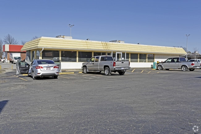
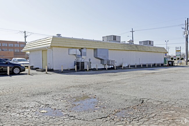
1233 W Walnut St
02-01244-000
WAFFLE HUT SITS ON 02-01243-001
Restaurantbuilding
Benton
B and X Area of moderate flood hazard, usually the area between the limits of the 100-year and 500-year floods.
Arkansas
0
East Rogers
2025
Fayetteville/Springdale/Rogers
020301
Fayetteville-Springdale-Rogers, AR
1,932 SF
NEARBY LISTINGS FOR SALE OR LEASE
DEMOGRAPHICS near 1233 W Walnut St
1 mile
3 mile
5 mile
2025 Total Population
11,196
57,311
105,601
2030 Population
12,312
62,965
116,747
Pop Growth 2025-2030
+ 9.97%
+ 9.87%
+ 10.55%
Average Age
37
37
37
2025 Total Households
4,299
20,584
39,310
HH Growth 2025-2030
+ 10.35%
+ 10.23%
+ 10.97%
Median Household Inc
$56,878
$69,786
$82,405
Avg Household Size
2.50
2.70
2.60
2025 Avg HH Vehicles
2.00
2.00
2.00
Median Home Value
$248,920
$277,376
$349,668
Median Year Built
1984
1991
1996
Nearby Places
Map Layers
Map Styles
 Street
 Aerial
Layers
 Traffic
 Biking
Places
Listings with unknown addresses are not visible on the map
- Restaurants
- Banks
- Shops
- Fitness
- Groceries
PUBLIC TRANSPORTATION
AIRPORT
Northwest Arkansas Ntl
Drive
Walk
Distance
Northwest Arkansas Ntl
30 min
14.0 mi
Nearby Properties
Address
Land Use
TOTAL SIZE
Lot Size
Zoning
Address
Land Use
TOTAL SIZE
Lot Size
Zoning
117,522 SF
0.12 AC
Address
Land Use
TOTAL SIZE
Lot Size
Zoning
746,783 SF
77.03 AC
Address
Land Use
TOTAL SIZE
Lot Size
Zoning
17,340 SF
14.15 AC
Address
Land Use
TOTAL SIZE
Lot Size
Zoning
542,873 SF
16.52 AC
Address
Land Use
TOTAL SIZE
Lot Size
Zoning
97,660 SF
5.35 AC
Address
Land Use
TOTAL SIZE
Lot Size
Zoning
166,973 SF
7.58 AC
Address
Land Use
TOTAL SIZE
Lot Size
Zoning
184,614 SF
5.04 AC
Address
Land Use
TOTAL SIZE
Lot Size
Zoning
30,456 SF
7.78 AC
Address
Land Use
TOTAL SIZE
Lot Size
Zoning
573,476 SF
57.80 AC
Address
Land Use
TOTAL SIZE
Lot Size
Zoning
152,925 SF
16.49 AC
Address
Land Use
TOTAL SIZE
Lot Size
Zoning
401,143 SF
31.17 AC
Address
Land Use
TOTAL SIZE
Lot Size
Zoning
210,971 SF
8.46 AC
Address
Land Use
TOTAL SIZE
Lot Size
Zoning
249,843 SF
19.21 AC
Address
Land Use
TOTAL SIZE
Lot Size
Zoning
128,374 SF
10.94 AC
Address
Land Use
TOTAL SIZE
Lot Size
Zoning
214,791 SF
9.13 AC
Address
Land Use
TOTAL SIZE
Lot Size
Zoning
156,100 SF
7.89 AC
Address
Land Use
TOTAL SIZE
Lot Size
Zoning
274,312 SF
12.24 AC
Address
Land Use
TOTAL SIZE
Lot Size
Zoning
152,759 SF
12.01 AC
Address
Land Use
TOTAL SIZE
Lot Size
Zoning
73,089 SF
3.67 AC
Address
Land Use
TOTAL SIZE
Lot Size
Zoning
114,250 SF
7.54 AC
Address
Land Use
TOTAL SIZE
Lot Size
Zoning
172,672 SF
11.09 AC
Address
Land Use
TOTAL SIZE
Lot Size
Zoning
117,522 SF
13.66 AC
Address
Land Use
TOTAL SIZE
Lot Size
Zoning
231,576 SF
15.18 AC
Address
Land Use
TOTAL SIZE
Lot Size
Zoning
102,477 SF
7.15 AC
Address
Land Use
TOTAL SIZE
Lot Size
Zoning
46,851 SF
4.28 AC
Address
Land Use
TOTAL SIZE
Lot Size
Zoning
94,189 SF
2.98 AC
Address
Land Use
TOTAL SIZE
Lot Size
Zoning
75,063 SF
2.50 AC
Address
Land Use
TOTAL SIZE
Lot Size
Zoning
87,465 SF
5 AC
Address
Land Use
TOTAL SIZE
Lot Size
Zoning
74,243 SF
14.03 AC
Address
Land Use
TOTAL SIZE
Lot Size
Zoning
205,851 SF
20.13 AC
The World's #1 Commercial Real Estate Marketplace
Connect with us
© 2026 CoStar Group
The information above has been obtained from sources believed reliable. While we do not doubt its accuracy we have not verified it and make no guarantee, warranty or representation about it. It is your responsibility to independently confirm its accuracy and completeness. Any projections, opinions, assumptions, or estimates used are for example only and do not represent the current or future performance of the property. The value of this transaction to you depends on tax and other factors which should be evaluated by your tax, financial, and legal advisors. You and your advisors should conduct a careful, independent investigation of the property to determine to your satisfaction the suitability of the property for your needs.