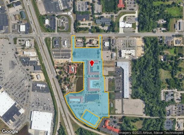
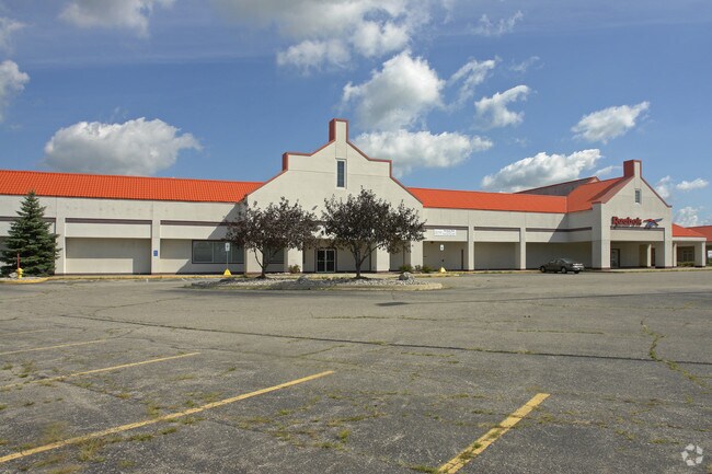
Property Record
12330 James St, Holland, MI 49424

NEARBY LISTINGS FOR SALE OR LEASE
Property Detail
12330 James St
70-16-21-200-080
PART OF NE 1/4 COM S 89D 40M 31S E 47232 FT FROM N 1/4 COR, TH S 89D 40M 31S E 60 FT, S 0D 23M 49S W 233 FT, S 89D 40M 31S E
Regionalshoppingcenterormallwithanchorstore
Ottawa
X
Michigan
26005C0040G
17.69 AC
2024
Holland East
2025
West Michigan
022207
Grand Rapids-Wyoming, MI
125,875 SF
DEMOGRAPHICS near 12330 James St
1 Mile
3 Mile
5 Mile
2024 Total Population
3,269
58,265
97,856
2029 Population
3,413
60,939
102,034
Pop Growth 2024-2029
+ 4.41%
+ 4.59%
+ 4.27%
Average Age
37
38
39
2024 Total Households
1,433
21,344
36,305
HH Growth 2024-2029
+ 4.75%
+ 4.81%
+ 4.40%
Median Household Inc
$44,062
$69,276
$72,985
Avg Household Size
2.20
2.50
2.60
2024 Avg HH Vehicles
2.00
2.00
2.00
Median Home Value
$177,115
$223,023
$236,840
Median Year Built
1990
1983
1984
Nearby Places
Map Layers
Map Styles
 Street
 Aerial
- Restaurants
- Banks
- Shops
- Fitness
- Groceries
PUBLIC TRANSPORTATION
COMMUTER RAIL
Holland Amtrak Station (Pere Marquette - Amtrak)
DRIVE
WALK
Distance
Holland Amtrak Station (Pere Marquette - Amtrak)
6 min
2.7 mi
AIRPORT
Gerald R Ford International
DRIVE
WALK
Distance
Gerald R Ford International
45 min
33.4 mi
Freight Ports
Port Milwaukee
DRIVE
WALK
Distance
Port Milwaukee
281 min
238.3 mi
Nearby Properties
Address
Land Use
TOTAL SIZE
Lot Size
Zoning
Address
Land Use
TOTAL SIZE
Lot Size
Zoning
572,832 SF
10.89 AC
PUD
Address
Land Use
TOTAL SIZE
Lot Size
Zoning
682,378 SF
99.60 AC
NA
Address
Land Use
TOTAL SIZE
Lot Size
Zoning
377,049 SF
24.47 AC
I-2
Address
Land Use
TOTAL SIZE
Lot Size
Zoning
346,440 SF
32.15 AC
PUD
Address
Land Use
TOTAL SIZE
Lot Size
Zoning
362,916 SF
19.23 AC
I-2
Address
Land Use
TOTAL SIZE
Lot Size
Zoning
391,255 SF
40.67 AC
I-2
Address
Land Use
TOTAL SIZE
Lot Size
Zoning
249,051 SF
24.77 AC
LDR
Address
Land Use
TOTAL SIZE
Lot Size
Zoning
3,150 SF
25.40 AC
AG
Address
Land Use
TOTAL SIZE
Lot Size
Zoning
660,002 SF
32.13 AC
I-2
Address
Land Use
TOTAL SIZE
Lot Size
Zoning
218,722 SF
8.59 AC
AGR
Address
Land Use
TOTAL SIZE
Lot Size
Zoning
176,802 SF
17.58 AC
AG
Address
Land Use
TOTAL SIZE
Lot Size
Zoning
320,270 SF
33.25 AC
PUD
Address
Land Use
TOTAL SIZE
Lot Size
Zoning
329,784 SF
38.51 AC
I-2
Address
Land Use
TOTAL SIZE
Lot Size
Zoning
131,497 SF
37.54 AC
I-2
Address
Land Use
TOTAL SIZE
Lot Size
Zoning
226,347 SF
19.44 AC
I-2
Address
Land Use
TOTAL SIZE
Lot Size
Zoning
1,040 SF
32.85 AC
I-2
Address
Land Use
TOTAL SIZE
Lot Size
Zoning
83,100 SF
Address
Land Use
TOTAL SIZE
Lot Size
Zoning
132,127 SF
42.69 AC
SEE MAP
Address
Land Use
TOTAL SIZE
Lot Size
Zoning
137,917 SF
I-2
Address
Land Use
TOTAL SIZE
Lot Size
Zoning
19.20 AC
AG
Address
Land Use
TOTAL SIZE
Lot Size
Zoning
90,508 SF
I-2
Address
Land Use
TOTAL SIZE
Lot Size
Zoning
210,792 SF
22.91 AC
C-2
Address
Land Use
TOTAL SIZE
Lot Size
Zoning
94,790 SF
1.74 AC
C-2
Address
Land Use
TOTAL SIZE
Lot Size
Zoning
58,710 SF
6.96 AC
C-2
Address
Land Use
TOTAL SIZE
Lot Size
Zoning
222,767 SF
26.59 AC
I-2
Address
Land Use
TOTAL SIZE
Lot Size
Zoning
209,455 SF
17 AC
C-2
Address
Land Use
TOTAL SIZE
Lot Size
Zoning
Address
Land Use
TOTAL SIZE
Lot Size
Zoning
177,800 SF
12.34 AC
I-2
Address
Land Use
TOTAL SIZE
Lot Size
Zoning
144,764 SF
16.32 AC
R-3
Address
Land Use
TOTAL SIZE
Lot Size
Zoning
134,490 SF
15.76 AC
C-2
The World's #1 Commercial Real Estate Marketplace
Connect with us
© 2025 CoStar Group
The information above has been obtained from sources believed reliable. While we do not doubt its accuracy we have not verified it and make no guarantee, warranty or representation about it. It is your responsibility to independently confirm its accuracy and completeness. Any projections, opinions, assumptions, or estimates used are for example only and do not represent the current or future performance of the property. The value of this transaction to you depends on tax and other factors which should be evaluated by your tax, financial, and legal advisors. You and your advisors should conduct a careful, independent investigation of the property to determine to your satisfaction the suitability of the property for your needs.