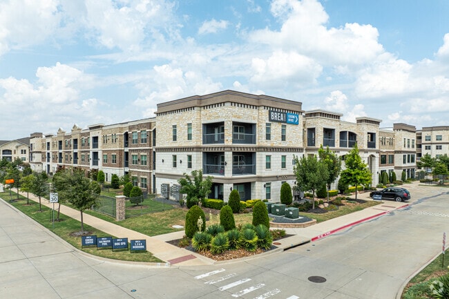
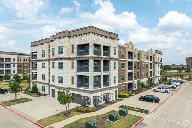
Property Record
12330 Research Rd, Frisco, TX 75033

Property Detail
12330 Research Rd
Dallas-Fort Worth-Arlington, TX
DAVIS MULTIFAMILY, BLK A, LOT 3
R-11185-00A-0030-1
COLLIN
Multifamilydwelling
Texas
AE The base floodplain where base flood elevations are provided. AE Zones are now used on new format FIRMs instead of A1-A30 Zones.
3
2025
23.69 AC
2025
Frisco
030519
Dallas/Ft Worth
516,677 SF
NEARBY LISTINGS FOR SALE OR LEASE
-
-
View all Frisco listings for sale on LoopNet.com
DEMOGRAPHICS near 12330 Research Rd
1 mile
3 mile
5 mile
2025 Total Population
4,230
71,092
276,437
2030 Population
5,011
81,234
314,213
Pop Growth 2025-2030
+ 18.46%
+ 14.27%
+ 13.67%
Average Age
35
36
36
2025 Total Households
1,756
24,332
90,233
HH Growth 2025-2030
+ 18.85%
+ 14.76%
+ 14.01%
Median Household Inc
$125,145
$146,614
$152,956
Avg Household Size
2.40
2.90
3.00
2025 Avg HH Vehicles
2.00
2.00
2.00
Median Home Value
$693,333
$700,067
$651,613
Median Year Built
2010
2010
2010
Nearby Places
Map Layers
Map Styles
 Street
 Aerial
Layers
 Traffic
 Biking
Places
Listings with unknown addresses are not visible on the map
- Restaurants
- Banks
- Shops
- Fitness
- Groceries
PUBLIC TRANSPORTATION
AIRPORT
Dallas Love Field
Drive
Walk
Distance
Dallas Love Field
38 min
28.3 mi
Dallas-Fort Worth International
Drive
Walk
Distance
Dallas-Fort Worth International
37 min
29.1 mi
Freight Ports
Port of Shreveport
Drive
Walk
Distance
Port of Shreveport
241 min
221.6 mi
Nearby Properties
Address
Land Use
TOTAL SIZE
Lot Size
Zoning
Address
Land Use
TOTAL SIZE
Lot Size
Zoning
479,244 SF
26.82 AC
COMM
Address
Land Use
TOTAL SIZE
Lot Size
Zoning
343,317 SF
17.17 AC
Address
Land Use
TOTAL SIZE
Lot Size
Zoning
64,912 SF
582.50 AC
Address
Land Use
TOTAL SIZE
Lot Size
Zoning
458,757 SF
83.22 AC
Address
Land Use
TOTAL SIZE
Lot Size
Zoning
797,358 SF
41.94 AC
Address
Land Use
TOTAL SIZE
Lot Size
Zoning
489,385 SF
10.24 AC
Address
Land Use
TOTAL SIZE
Lot Size
Zoning
491,094 SF
14.06 AC
Address
Land Use
TOTAL SIZE
Lot Size
Zoning
431,308 SF
4.28 AC
COMM
Address
Land Use
TOTAL SIZE
Lot Size
Zoning
151,733 SF
Address
Land Use
TOTAL SIZE
Lot Size
Zoning
236,513 SF
99.95 AC
Address
Land Use
TOTAL SIZE
Lot Size
Zoning
329,460 SF
63.31 AC
Address
Land Use
TOTAL SIZE
Lot Size
Zoning
352,470 SF
96.59 AC
Address
Land Use
TOTAL SIZE
Lot Size
Zoning
438,092 SF
6.32 AC
Address
Land Use
TOTAL SIZE
Lot Size
Zoning
493,823 SF
2.44 AC
Address
Land Use
TOTAL SIZE
Lot Size
Zoning
533,937 SF
17.44 AC
MF-M
Address
Land Use
TOTAL SIZE
Lot Size
Zoning
510,032 SF
7.47 AC
Address
Land Use
TOTAL SIZE
Lot Size
Zoning
346,252 SF
11.32 AC
Address
Land Use
TOTAL SIZE
Lot Size
Zoning
386,806 SF
22.59 AC
Address
Land Use
TOTAL SIZE
Lot Size
Zoning
137,000 SF
4.71 AC
Address
Land Use
TOTAL SIZE
Lot Size
Zoning
416,345 SF
3.72 AC
COMM
Address
Land Use
TOTAL SIZE
Lot Size
Zoning
389,116 SF
9.72 AC
Address
Land Use
TOTAL SIZE
Lot Size
Zoning
536,616 SF
23.21 AC
MF-M
Address
Land Use
TOTAL SIZE
Lot Size
Zoning
334,425 SF
3.83 AC
MF-E
Address
Land Use
TOTAL SIZE
Lot Size
Zoning
360,589 SF
22.99 AC
MU
Address
Land Use
TOTAL SIZE
Lot Size
Zoning
96,338 SF
5.14 AC
Address
Land Use
TOTAL SIZE
Lot Size
Zoning
308,202 SF
3.69 AC
Address
Land Use
TOTAL SIZE
Lot Size
Zoning
264,219 SF
5.35 AC
Address
Land Use
TOTAL SIZE
Lot Size
Zoning
339,685 SF
13.82 AC
MF
Address
Land Use
TOTAL SIZE
Lot Size
Zoning
352,475 SF
16.80 AC
MF-M
The World's #1 Commercial Real Estate Marketplace
Connect with us
© 2026 CoStar Group
The information above has been obtained from sources believed reliable. While we do not doubt its accuracy we have not verified it and make no guarantee, warranty or representation about it. It is your responsibility to independently confirm its accuracy and completeness. Any projections, opinions, assumptions, or estimates used are for example only and do not represent the current or future performance of the property. The value of this transaction to you depends on tax and other factors which should be evaluated by your tax, financial, and legal advisors. You and your advisors should conduct a careful, independent investigation of the property to determine to your satisfaction the suitability of the property for your needs.