Property Record
12331 S Interstate 45 N, Willis, TX 77318
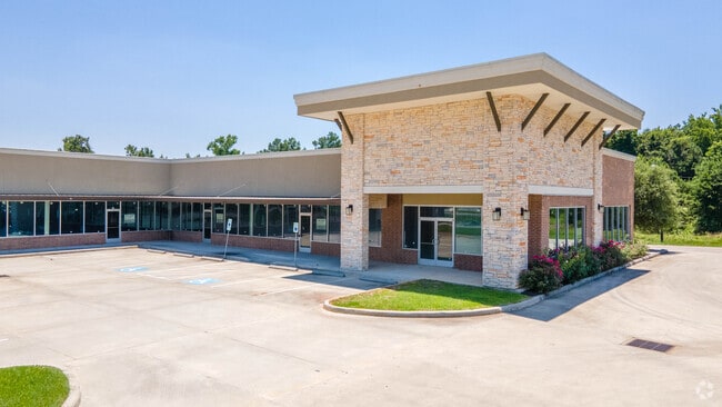


Property Detail
12331 S Interstate 45 N
0313-01-04010
A0313 - LONIS GEO W TRACT 40-A (PAM RETAIL CENTER # 2016076108, BLOCK 1, RES B), ACRES 1.28
Commercialnec
MONTGOMERY
4
Texas
B and X Area of moderate flood hazard, usually the area between the limits of the 100-year and 500-year floods.
1.28 AC
2024
Montgomery County
2025
Houston
694203
Houston-Pasadena-The Woodlands, TX
12,656 SF
NEARBY LISTINGS FOR SALE OR LEASE
DEMOGRAPHICS near 12331 S Interstate 45 N
1 mile
3 mile
5 mile
2025 Total Population
4,146
23,513
54,858
2030 Population
4,892
27,993
65,308
Pop Growth 2025-2030
+ 17.99%
+ 19.05%
+ 19.05%
Average Age
35
38
40
2025 Total Households
1,386
8,243
19,909
HH Growth 2025-2030
+ 18.54%
+ 19.65%
+ 19.62%
Median Household Inc
$52,156
$71,691
$84,402
Avg Household Size
3.00
2.80
2.70
2025 Avg HH Vehicles
2.00
2.00
2.00
Median Home Value
$254,575
$274,925
$301,483
Median Year Built
2000
2004
2004
Nearby Places
Map Layers
Map Styles
 Street
 Aerial
Transit
 Traffic
 Biking
Places
Listings with unknown addresses are not visible on the map
- Restaurants
- Banks
- Shops
- Fitness
- Groceries
SALE & LEASE HISTORY
LISTING DATE
SALE/LEASE

Dec 14, 2017
For Lease
Nearby Properties
Address
Land Use
TOTAL SIZE
Lot Size
Zoning
Address
Land Use
TOTAL SIZE
Lot Size
Zoning
Address
Land Use
TOTAL SIZE
Lot Size
Zoning
1,583.40 AC
4
Address
Land Use
TOTAL SIZE
Lot Size
Zoning
448,675 SF
52.68 AC
4
Address
Land Use
TOTAL SIZE
Lot Size
Zoning
251,207 SF
45 AC
Address
Land Use
TOTAL SIZE
Lot Size
Zoning
117,918 SF
13.63 AC
Address
Land Use
TOTAL SIZE
Lot Size
Zoning
204,759 SF
31.46 AC
Address
Land Use
TOTAL SIZE
Lot Size
Zoning
265,346 SF
74.32 AC
4
Address
Land Use
TOTAL SIZE
Lot Size
Zoning
73,812 SF
9.51 AC
Address
Land Use
TOTAL SIZE
Lot Size
Zoning
87,983 SF
13.90 AC
Address
Land Use
TOTAL SIZE
Lot Size
Zoning
198,970 SF
10.95 AC
Address
Land Use
TOTAL SIZE
Lot Size
Zoning
34,832 SF
31.27 AC
Address
Land Use
TOTAL SIZE
Lot Size
Zoning
203,735 SF
9.26 AC
4
Address
Land Use
TOTAL SIZE
Lot Size
Zoning
31,078 SF
14.11 AC
4
Address
Land Use
TOTAL SIZE
Lot Size
Zoning
57,431 SF
35.06 AC
4
Address
Land Use
TOTAL SIZE
Lot Size
Zoning
27,868 SF
2.97 AC
Address
Land Use
TOTAL SIZE
Lot Size
Zoning
31,019 SF
3.68 AC
4
Address
Land Use
TOTAL SIZE
Lot Size
Zoning
14,486 SF
1.47 AC
Address
Land Use
TOTAL SIZE
Lot Size
Zoning
37,752 SF
25.03 AC
4
Address
Land Use
TOTAL SIZE
Lot Size
Zoning
29,311 SF
9.09 AC
4
Address
Land Use
TOTAL SIZE
Lot Size
Zoning
84,985 SF
12 AC
4
Address
Land Use
TOTAL SIZE
Lot Size
Zoning
13,650 SF
1.70 AC
Address
Land Use
TOTAL SIZE
Lot Size
Zoning
38.04 AC
Address
Land Use
TOTAL SIZE
Lot Size
Zoning
15,000 SF
1.84 AC
Address
Land Use
TOTAL SIZE
Lot Size
Zoning
4,420 SF
21.95 AC
4
Address
Land Use
TOTAL SIZE
Lot Size
Zoning
17,048 SF
11.80 AC
4
Address
Land Use
TOTAL SIZE
Lot Size
Zoning
41,158 SF
33.75 AC
4
Address
Land Use
TOTAL SIZE
Lot Size
Zoning
5,380 SF
25.74 AC
Address
Land Use
TOTAL SIZE
Lot Size
Zoning
10.86 AC
The World's #1 Commercial Real Estate Marketplace
Connect with us
© 2026 CoStar Group
The information above has been obtained from sources believed reliable. While we do not doubt its accuracy we have not verified it and make no guarantee, warranty or representation about it. It is your responsibility to independently confirm its accuracy and completeness. Any projections, opinions, assumptions, or estimates used are for example only and do not represent the current or future performance of the property. The value of this transaction to you depends on tax and other factors which should be evaluated by your tax, financial, and legal advisors. You and your advisors should conduct a careful, independent investigation of the property to determine to your satisfaction the suitability of the property for your needs.