Property Record
12338 Fm 2854 Rd, Conroe, TX 77304
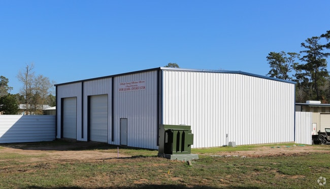

Property Detail
12338 Fm 2854 Rd
Houston-Pasadena-The Woodlands, TX
S886500 - SUE NICHOLS ADDITION, BLOCK 1, LOT 1-B, ACRES 8.32
8865-00-00105
Montgomery
Commercialnec
Texas
B and X Area of moderate flood hazard, usually the area between the limits of the 100-year and 500-year floods.
1-b
2024
8.32 AC
2025
The Woodlands/Conroe
694401
Houston
4,100 SF
NEARBY LISTINGS FOR SALE OR LEASE
-
-
View all Conroe listings for lease on LoopNet.com
DEMOGRAPHICS near 12338 Fm 2854 Rd
1 mile
3 mile
5 mile
2025 Total Population
2,047
24,569
82,137
2030 Population
2,423
29,159
97,529
Pop Growth 2025-2030
+ 18.37%
+ 18.68%
+ 18.74%
Average Age
40
39
39
2025 Total Households
781
9,237
31,663
HH Growth 2025-2030
+ 18.95%
+ 19.16%
+ 19.18%
Median Household Inc
$89,141
$108,693
$93,634
Avg Household Size
2.60
2.60
2.60
2025 Avg HH Vehicles
2.00
2.00
2.00
Median Home Value
$348,888
$442,006
$401,248
Median Year Built
2011
2011
2010
Nearby Places
Map Layers
Map Styles
 Street
 Aerial
Layers
 Traffic
 Biking
Places
Listings with unknown addresses are not visible on the map
- Restaurants
- Banks
- Shops
- Fitness
- Groceries
PUBLIC TRANSPORTATION
AIRPORT
George Bush Intcntl/Houston
Drive
Walk
Distance
George Bush Intcntl/Houston
45 min
36.1 mi
Freight Ports
Port of Houston
Drive
Walk
Distance
Port of Houston
68 min
51.8 mi
SALE & LEASE HISTORY
LISTING DATE
SALE/LEASE

May 01, 2017
For Lease
Mar 08, 2017
For Lease
Jan 09, 2023
For Lease
Dec 16, 2019
For Lease
Nearby Properties
Address
Land Use
TOTAL SIZE
Lot Size
Zoning
Address
Land Use
TOTAL SIZE
Lot Size
Zoning
296,593 SF
13.03 AC
Address
Land Use
TOTAL SIZE
Lot Size
Zoning
294,336 SF
20.39 AC
Address
Land Use
TOTAL SIZE
Lot Size
Zoning
204,716 SF
15.51 AC
Address
Land Use
TOTAL SIZE
Lot Size
Zoning
229,345 SF
12.36 AC
1
Address
Land Use
TOTAL SIZE
Lot Size
Zoning
134,935 SF
10.50 AC
1
Address
Land Use
TOTAL SIZE
Lot Size
Zoning
134,621 SF
26.37 AC
Address
Land Use
TOTAL SIZE
Lot Size
Zoning
313,974 SF
25.03 AC
1
Address
Land Use
TOTAL SIZE
Lot Size
Zoning
228,088 SF
16.16 AC
Address
Land Use
TOTAL SIZE
Lot Size
Zoning
157,996 SF
9 AC
Address
Land Use
TOTAL SIZE
Lot Size
Zoning
125,042 SF
7.39 AC
Address
Land Use
TOTAL SIZE
Lot Size
Zoning
203,934 SF
11.75 AC
Address
Land Use
TOTAL SIZE
Lot Size
Zoning
382,810 SF
18.58 AC
1
Address
Land Use
TOTAL SIZE
Lot Size
Zoning
114,547 SF
57.94 AC
1
Address
Land Use
TOTAL SIZE
Lot Size
Zoning
17,544 SF
24.25 AC
1
Address
Land Use
TOTAL SIZE
Lot Size
Zoning
42,750 SF
4.75 AC
Address
Land Use
TOTAL SIZE
Lot Size
Zoning
402,840 SF
26.73 AC
Address
Land Use
TOTAL SIZE
Lot Size
Zoning
50,464 SF
7.95 AC
Address
Land Use
TOTAL SIZE
Lot Size
Zoning
81,011 SF
21.53 AC
Address
Land Use
TOTAL SIZE
Lot Size
Zoning
170,050 SF
10.80 AC
Address
Land Use
TOTAL SIZE
Lot Size
Zoning
21,875 SF
2.44 AC
Address
Land Use
TOTAL SIZE
Lot Size
Zoning
45,301 SF
13.18 AC
1
Address
Land Use
TOTAL SIZE
Lot Size
Zoning
68,576 SF
26.39 AC
Address
Land Use
TOTAL SIZE
Lot Size
Zoning
74,395 SF
8.44 AC
Address
Land Use
TOTAL SIZE
Lot Size
Zoning
35,816 SF
251.16 AC
1
Address
Land Use
TOTAL SIZE
Lot Size
Zoning
46,374 SF
3.76 AC
Address
Land Use
TOTAL SIZE
Lot Size
Zoning
104,735 SF
29.96 AC
1
Address
Land Use
TOTAL SIZE
Lot Size
Zoning
14,729 SF
2.26 AC
Address
Land Use
TOTAL SIZE
Lot Size
Zoning
26,278 SF
9.39 AC
Address
Land Use
TOTAL SIZE
Lot Size
Zoning
19,474 SF
12.76 AC
The World's #1 Commercial Real Estate Marketplace
Connect with us
© 2026 CoStar Group
The information above has been obtained from sources believed reliable. While we do not doubt its accuracy we have not verified it and make no guarantee, warranty or representation about it. It is your responsibility to independently confirm its accuracy and completeness. Any projections, opinions, assumptions, or estimates used are for example only and do not represent the current or future performance of the property. The value of this transaction to you depends on tax and other factors which should be evaluated by your tax, financial, and legal advisors. You and your advisors should conduct a careful, independent investigation of the property to determine to your satisfaction the suitability of the property for your needs.