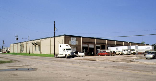
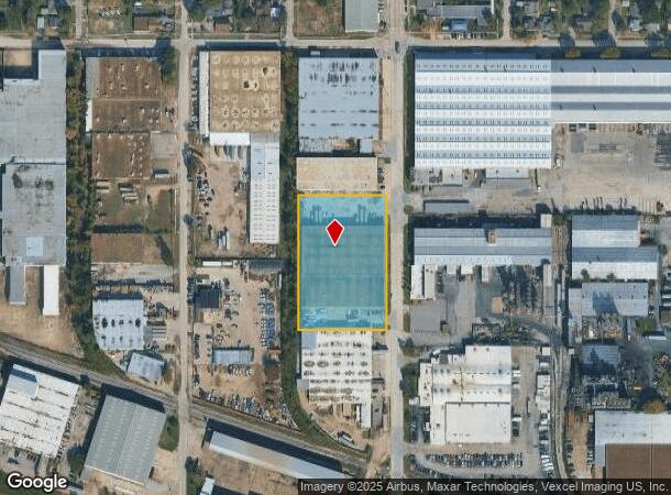
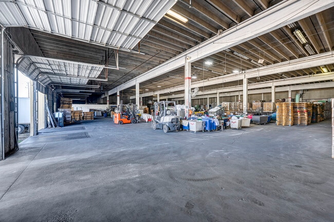
Property Record
1230 Kress St, Houston, TX 77020
Current Lease Availabilities
NEARBY LISTINGS FOR SALE OR LEASE
Property Detail
1230 Kress St
0402650010028
Abst 32 Harris & Wilson
Warehouse
TRS G4 G5 & G7 KOUNSLAR ABST 32 HARRIS & WILSON
X
Harris
48201C0695M
Texas
2024
2.66 AC
2025
Downtown Houston
211502
Houston
65,527 SF
Houston-The Woodlands-Sugar Land, TX
DEMOGRAPHICS near 1230 Kress St
1 Mile
3 Mile
5 Mile
2024 Total Population
9,057
110,576
327,426
2029 Population
9,321
114,466
339,264
Pop Growth 2024-2029
+ 2.91%
+ 3.52%
+ 3.62%
Average Age
37
38
37
2024 Total Households
2,982
38,578
123,981
HH Growth 2024-2029
+ 2.95%
+ 3.94%
+ 3.97%
Median Household Inc
$34,662
$38,780
$49,269
Avg Household Size
3.00
2.60
2.40
2024 Avg HH Vehicles
2.00
2.00
2.00
Median Home Value
$98,810
$169,757
$196,257
Median Year Built
1952
1957
1966
Nearby Places
- Restaurants
- Banks
- Shops
- Fitness
- Groceries
PUBLIC TRANSPORTATION
COMMUTER RAIL
Houston (Sunset Limited - Amtrak)
DRIVE
WALK
Distance
Houston (Sunset Limited - Amtrak)
9 min
4.9 mi
AIRPORT
William P Hobby
DRIVE
WALK
Distance
William P Hobby
24 min
11.7 mi
George Bush Intcntl/Houston
DRIVE
WALK
Distance
George Bush Intcntl/Houston
28 min
19.9 mi
Freight Ports
Port of Houston
DRIVE
WALK
Distance
Port of Houston
12 min
4.8 mi
Nearby Properties
Address
Land Use
TOTAL SIZE
Lot Size
Zoning
Address
Land Use
TOTAL SIZE
Lot Size
Zoning
100.26 AC
Address
Land Use
TOTAL SIZE
Lot Size
Zoning
12,206,592 SF
212.18 AC
Address
Land Use
TOTAL SIZE
Lot Size
Zoning
1,392,720 SF
83.75 AC
Address
Land Use
TOTAL SIZE
Lot Size
Zoning
644,794 SF
3.38 AC
Address
Land Use
TOTAL SIZE
Lot Size
Zoning
587,515 SF
4.85 AC
Address
Land Use
TOTAL SIZE
Lot Size
Zoning
400,641 SF
1.86 AC
Address
Land Use
TOTAL SIZE
Lot Size
Zoning
406,772 SF
4.30 AC
Address
Land Use
TOTAL SIZE
Lot Size
Zoning
793,077 SF
49.76 AC
Address
Land Use
TOTAL SIZE
Lot Size
Zoning
199,210 SF
1.44 AC
Address
Land Use
TOTAL SIZE
Lot Size
Zoning
463,768 SF
6.23 AC
Address
Land Use
TOTAL SIZE
Lot Size
Zoning
406,586 SF
4.03 AC
Address
Land Use
TOTAL SIZE
Lot Size
Zoning
186,808 SF
4.73 AC
Address
Land Use
TOTAL SIZE
Lot Size
Zoning
242,936 SF
Address
Land Use
TOTAL SIZE
Lot Size
Zoning
17.84 AC
Address
Land Use
TOTAL SIZE
Lot Size
Zoning
186,460 SF
1.45 AC
Address
Land Use
TOTAL SIZE
Lot Size
Zoning
Address
Land Use
TOTAL SIZE
Lot Size
Zoning
498,726 SF
4.97 AC
Address
Land Use
TOTAL SIZE
Lot Size
Zoning
901,984 SF
59.37 AC
Address
Land Use
TOTAL SIZE
Lot Size
Zoning
923,370 SF
13.72 AC
Address
Land Use
TOTAL SIZE
Lot Size
Zoning
785,097 SF
27.77 AC
Address
Land Use
TOTAL SIZE
Lot Size
Zoning
224,741 SF
10.75 AC
Address
Land Use
TOTAL SIZE
Lot Size
Zoning
111,415 SF
0.93 AC
Address
Land Use
TOTAL SIZE
Lot Size
Zoning
240,968 SF
12.45 AC
Address
Land Use
TOTAL SIZE
Lot Size
Zoning
985,528 SF
22.64 AC
Address
Land Use
TOTAL SIZE
Lot Size
Zoning
923,370 SF
13.76 AC
Address
Land Use
TOTAL SIZE
Lot Size
Zoning
200,902 SF
4.36 AC
Address
Land Use
TOTAL SIZE
Lot Size
Zoning
595,069 SF
17.77 AC
Address
Land Use
TOTAL SIZE
Lot Size
Zoning
190,512 SF
8.81 AC
Address
Land Use
TOTAL SIZE
Lot Size
Zoning
225,393 SF
20.59 AC
Address
Land Use
TOTAL SIZE
Lot Size
Zoning
80,150 SF
0.65 AC
The World's #1 Commercial Real Estate Marketplace
Connect with us
© 2025 CoStar Group
The information above has been obtained from sources believed reliable. While we do not doubt its accuracy we have not verified it and make no guarantee, warranty or representation about it. It is your responsibility to independently confirm its accuracy and completeness. Any projections, opinions, assumptions, or estimates used are for example only and do not represent the current or future performance of the property. The value of this transaction to you depends on tax and other factors which should be evaluated by your tax, financial, and legal advisors. You and your advisors should conduct a careful, independent investigation of the property to determine to your satisfaction the suitability of the property for your needs.