Property Record
12342 State Highway 64 W, Tyler, TX 75704


Save to a Folder
{{folder.Name}}
{{folder.ListingIds.length}} Properties
{{folder.ListingIds.length}} Property
Create a New Folder
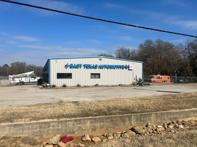
Property Detail
12342 State Highway 64 W
Tyler, TX
NOBLE-HOGUE ADDN LOT 2 2017 NEW SUBD
1-56540-0000-00-002000
SMITH
Autorepair
Texas
B and X Area of moderate flood hazard, usually the area between the limits of the 100-year and 500-year floods.
2
2025
1.50 AC
2025
Tyler
001608
Other Market Areas
9,000 SF
NEARBY LISTINGS FOR SALE OR LEASE
DEMOGRAPHICS near 12342 State Highway 64 W
1 mile
3 mile
5 mile
2025 Total Population
3,094
16,838
58,461
2030 Population
3,301
17,756
61,771
Pop Growth 2025-2030
+ 6.69%
+ 5.45%
+ 5.66%
Average Age
38
37
37
2025 Total Households
1,083
5,802
20,863
HH Growth 2025-2030
+ 6.09%
+ 5.02%
+ 5.16%
Median Household Inc
$55,735
$58,328
$54,779
Avg Household Size
2.70
2.80
2.60
2025 Avg HH Vehicles
2.00
2.00
2.00
Median Home Value
$171,535
$147,118
$146,614
Median Year Built
1975
1971
1968
Nearby Places
Map Layers
Map Styles
 Street
 Aerial
Layers
 Traffic
 Biking
Places
Listings with unknown addresses are not visible on the map
- Restaurants
- Banks
- Shops
- Fitness
- Groceries
PUBLIC TRANSPORTATION
AIRPORT
Tyler Pounds Regional
Drive
Walk
Distance
Tyler Pounds Regional
8 min
3.5 mi
Freight Ports
Port of Shreveport
Drive
Walk
Distance
Port of Shreveport
127 min
110.5 mi
SALE & LEASE HISTORY
LISTING DATE
SALE/LEASE

Feb 10, 2025
For Sale
Nearby Properties
Address
Land Use
TOTAL SIZE
Lot Size
Zoning
Address
Land Use
TOTAL SIZE
Lot Size
Zoning
24.83 AC
Address
Land Use
TOTAL SIZE
Lot Size
Zoning
39.16 AC
C2
Address
Land Use
TOTAL SIZE
Lot Size
Zoning
31.74 AC
Address
Land Use
TOTAL SIZE
Lot Size
Zoning
71,337 SF
15.70 AC
M1
Address
Land Use
TOTAL SIZE
Lot Size
Zoning
Address
Land Use
TOTAL SIZE
Lot Size
Zoning
187.64 AC
R1A
Address
Land Use
TOTAL SIZE
Lot Size
Zoning
311.96 AC
Address
Land Use
TOTAL SIZE
Lot Size
Zoning
126.94 AC
Address
Land Use
TOTAL SIZE
Lot Size
Zoning
63 AC
R1A
Address
Land Use
TOTAL SIZE
Lot Size
Zoning
22.85 AC
Address
Land Use
TOTAL SIZE
Lot Size
Zoning
Address
Land Use
TOTAL SIZE
Lot Size
Zoning
722 SF
14 AC
RMF
Address
Land Use
TOTAL SIZE
Lot Size
Zoning
14.16 AC
Address
Land Use
TOTAL SIZE
Lot Size
Zoning
45,114 SF
30.60 AC
Address
Land Use
TOTAL SIZE
Lot Size
Zoning
80,070 SF
9.04 AC
Address
Land Use
TOTAL SIZE
Lot Size
Zoning
205,196 SF
25.19 AC
C2
Address
Land Use
TOTAL SIZE
Lot Size
Zoning
85,804 SF
8.69 AC
M1
Address
Land Use
TOTAL SIZE
Lot Size
Zoning
25.57 AC
Address
Land Use
TOTAL SIZE
Lot Size
Zoning
60,956 SF
8.31 AC
M1
Address
Land Use
TOTAL SIZE
Lot Size
Zoning
300,000 SF
27.95 AC
M1
Address
Land Use
TOTAL SIZE
Lot Size
Zoning
60,328 SF
8 AC
M1
Address
Land Use
TOTAL SIZE
Lot Size
Zoning
51,000 SF
52.09 AC
Address
Land Use
TOTAL SIZE
Lot Size
Zoning
171,588 SF
16.21 AC
Address
Land Use
TOTAL SIZE
Lot Size
Zoning
5,437 SF
149.75 AC
R1A
Address
Land Use
TOTAL SIZE
Lot Size
Zoning
135,792 SF
12.05 AC
C1
Address
Land Use
TOTAL SIZE
Lot Size
Zoning
10.78 AC
R2
Address
Land Use
TOTAL SIZE
Lot Size
Zoning
136,482 SF
12.22 AC
C2
Address
Land Use
TOTAL SIZE
Lot Size
Zoning
92,268 SF
8.48 AC
C2
Address
Land Use
TOTAL SIZE
Lot Size
Zoning
352.91 AC
OSP
Address
Land Use
TOTAL SIZE
Lot Size
Zoning
64,882 SF
6.07 AC
C1
The World's #1 Commercial Real Estate Marketplace
Connect with us
© 2026 CoStar Group
The information above has been obtained from sources believed reliable. While we do not doubt its accuracy we have not verified it and make no guarantee, warranty or representation about it. It is your responsibility to independently confirm its accuracy and completeness. Any projections, opinions, assumptions, or estimates used are for example only and do not represent the current or future performance of the property. The value of this transaction to you depends on tax and other factors which should be evaluated by your tax, financial, and legal advisors. You and your advisors should conduct a careful, independent investigation of the property to determine to your satisfaction the suitability of the property for your needs.