Property Record
12345 Navajo Rd, Apple Valley, CA 92308


NEARBY LISTINGS FOR SALE OR LEASE
-
-
View all Apple Valley listings for sale on LoopNet.com
Property Detail
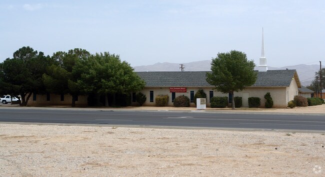
12345 Navajo Rd
Riverside-San Bernardino-Ontario, CA
Town Of Apple Valley
3087-521-04
TRACT 3459 LOT 27 EX N 300 FT AND EX ST
Religious
San Bernardino
D
California
06071C6505J
27
2024
2.11 AC
2025
Mojave River Valley
009712
Inland Empire (California)
818 SF
DEMOGRAPHICS near 12345 Navajo Rd
1 Mile
3 Mile
5 Mile
2024 Total Population
8,215
38,181
83,611
2029 Population
8,320
38,818
85,491
Pop Growth 2024-2029
+ 1.28%
+ 1.67%
+ 2.25%
Average Age
36
37
40
2024 Total Households
2,605
12,302
28,666
HH Growth 2024-2029
+ 1.23%
+ 1.67%
+ 2.28%
Median Household Inc
$47,989
$60,130
$71,430
Avg Household Size
3.10
3.00
2.90
2024 Avg HH Vehicles
2.00
2.00
2.00
Median Home Value
$265,012
$328,215
$375,609
Median Year Built
1984
1985
1986
Nearby Places
Map Layers
Map Styles
 Street
 Aerial
- Restaurants
- Banks
- Shops
- Fitness
- Groceries
PUBLIC TRANSPORTATION
COMMUTER RAIL
Victorville Amtrak (Southwest Chief - Amtrak)
DRIVE
WALK
Distance
Victorville Amtrak (Southwest Chief - Amtrak)
15 min
9.0 mi
Freight Ports
Port of Long Beach
DRIVE
WALK
Distance
Port of Long Beach
123 min
101.7 mi
Nearby Properties
Address
Land Use
TOTAL SIZE
Lot Size
Zoning
Address
Land Use
TOTAL SIZE
Lot Size
Zoning
116,365 SF
8.93 AC
Address
Land Use
TOTAL SIZE
Lot Size
Zoning
137,104 SF
12 AC
Address
Land Use
TOTAL SIZE
Lot Size
Zoning
74.39 AC
Address
Land Use
TOTAL SIZE
Lot Size
Zoning
18,800 SF
2.60 AC
Address
Land Use
TOTAL SIZE
Lot Size
Zoning
75,280 SF
4.07 AC
Address
Land Use
TOTAL SIZE
Lot Size
Zoning
127,429 SF
4.62 AC
Address
Land Use
TOTAL SIZE
Lot Size
Zoning
33,298 SF
1.99 AC
Address
Land Use
TOTAL SIZE
Lot Size
Zoning
14,739 SF
1.38 AC
Address
Land Use
TOTAL SIZE
Lot Size
Zoning
16,804 SF
1.80 AC
Address
Land Use
TOTAL SIZE
Lot Size
Zoning
35,178 SF
3.44 AC
Address
Land Use
TOTAL SIZE
Lot Size
Zoning
22,488 SF
3.05 AC
Address
Land Use
TOTAL SIZE
Lot Size
Zoning
86,148 SF
5.38 AC
Address
Land Use
TOTAL SIZE
Lot Size
Zoning
4,998 SF
2.76 AC
Address
Land Use
TOTAL SIZE
Lot Size
Zoning
42,394 SF
4.15 AC
Address
Land Use
TOTAL SIZE
Lot Size
Zoning
55,415 SF
2.91 AC
Address
Land Use
TOTAL SIZE
Lot Size
Zoning
53,972 SF
4.80 AC
Address
Land Use
TOTAL SIZE
Lot Size
Zoning
3,500 SF
0.51 AC
Address
Land Use
TOTAL SIZE
Lot Size
Zoning
22,700 SF
6.19 AC
Address
Land Use
TOTAL SIZE
Lot Size
Zoning
60.38 AC
Address
Land Use
TOTAL SIZE
Lot Size
Zoning
37,521 SF
24.52 AC
Address
Land Use
TOTAL SIZE
Lot Size
Zoning
9,545 SF
0.52 AC
Address
Land Use
TOTAL SIZE
Lot Size
Zoning
8,970 SF
0.78 AC
Address
Land Use
TOTAL SIZE
Lot Size
Zoning
6,572 SF
1.26 AC
Address
Land Use
TOTAL SIZE
Lot Size
Zoning
15,885 SF
4.38 AC
Address
Land Use
TOTAL SIZE
Lot Size
Zoning
870 SF
0.79 AC
Address
Land Use
TOTAL SIZE
Lot Size
Zoning
31,524 SF
2.94 AC
Address
Land Use
TOTAL SIZE
Lot Size
Zoning
15,740 SF
4.23 AC
Address
Land Use
TOTAL SIZE
Lot Size
Zoning
12,320 SF
0.92 AC
Address
Land Use
TOTAL SIZE
Lot Size
Zoning
14,735 SF
1.42 AC
Address
Land Use
TOTAL SIZE
Lot Size
Zoning
2,247 SF
0.73 AC
The World's #1 Commercial Real Estate Marketplace
Connect with us
© 2025 CoStar Group
The information above has been obtained from sources believed reliable. While we do not doubt its accuracy we have not verified it and make no guarantee, warranty or representation about it. It is your responsibility to independently confirm its accuracy and completeness. Any projections, opinions, assumptions, or estimates used are for example only and do not represent the current or future performance of the property. The value of this transaction to you depends on tax and other factors which should be evaluated by your tax, financial, and legal advisors. You and your advisors should conduct a careful, independent investigation of the property to determine to your satisfaction the suitability of the property for your needs.