Property Record
12345 Pauls Valley Rd, Dripping Springs, TX 78620
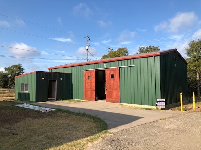

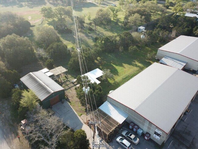
Property Detail
12345 Pauls Valley Rd
Austin-Round Rock-San Marcos, TX
RAY MOORE SUBDIVISION, LOT 1, ACRES 5.01
R110489
HAYS
Commercialnec
Texas
B and X Area of moderate flood hazard, usually the area between the limits of the 100-year and 500-year floods.
1
2024
5.01 AC
2025
Hays County
010817
Austin
1,120 SF
NEARBY LISTINGS FOR SALE OR LEASE
DEMOGRAPHICS near 12345 Pauls Valley Rd
1 mile
3 mile
5 mile
2025 Total Population
522
9,867
32,649
2030 Population
596
11,473
37,335
Pop Growth 2025-2030
+ 14.18%
+ 16.28%
+ 14.35%
Average Age
42
41
40
2025 Total Households
196
3,601
11,472
HH Growth 2025-2030
+ 15.31%
+ 17.36%
+ 15.39%
Median Household Inc
$142,391
$157,036
$171,752
Avg Household Size
2.60
2.70
2.80
2025 Avg HH Vehicles
3.00
2.00
2.00
Median Home Value
$817,164
$772,102
$779,577
Median Year Built
2005
2009
2010
Nearby Places
Map Layers
Map Styles
 Street
 Aerial
Layers
 Traffic
 Biking
Places
Listings with unknown addresses are not visible on the map
- Restaurants
- Banks
- Shops
- Fitness
- Groceries
PUBLIC TRANSPORTATION
AIRPORT
Austin-Bergstrom International
Drive
Walk
Distance
Austin-Bergstrom International
44 min
24.6 mi
SALE & LEASE HISTORY
LISTING DATE
SALE/LEASE

Sep 29, 2023
For Lease
Aug 26, 2020
For Lease
Aug 23, 2019
For Lease
Apr 12, 2018
For Lease
Nearby Properties
Address
Land Use
TOTAL SIZE
Lot Size
Zoning
Address
Land Use
TOTAL SIZE
Lot Size
Zoning
399,662 SF
16.72 AC
Address
Land Use
TOTAL SIZE
Lot Size
Zoning
324,987 SF
8.29 AC
Address
Land Use
TOTAL SIZE
Lot Size
Zoning
191,928 SF
4.79 AC
Address
Land Use
TOTAL SIZE
Lot Size
Zoning
219,299 SF
4.89 AC
Address
Land Use
TOTAL SIZE
Lot Size
Zoning
275,753 SF
15.68 AC
Address
Land Use
TOTAL SIZE
Lot Size
Zoning
64,670 SF
13.53 AC
Address
Land Use
TOTAL SIZE
Lot Size
Zoning
231,472 SF
9.53 AC
Address
Land Use
TOTAL SIZE
Lot Size
Zoning
79,524 SF
120.18 AC
Address
Land Use
TOTAL SIZE
Lot Size
Zoning
Address
Land Use
TOTAL SIZE
Lot Size
Zoning
77,801 SF
14.49 AC
Address
Land Use
TOTAL SIZE
Lot Size
Zoning
37,380 SF
4.35 AC
Address
Land Use
TOTAL SIZE
Lot Size
Zoning
33,145 SF
2.70 AC
Address
Land Use
TOTAL SIZE
Lot Size
Zoning
3 SF
14.51 AC
Address
Land Use
TOTAL SIZE
Lot Size
Zoning
15,750 SF
1.94 AC
Address
Land Use
TOTAL SIZE
Lot Size
Zoning
17,987 SF
12.07 AC
Address
Land Use
TOTAL SIZE
Lot Size
Zoning
15,000 SF
8.73 AC
Address
Land Use
TOTAL SIZE
Lot Size
Zoning
15,639 SF
2.10 AC
Address
Land Use
TOTAL SIZE
Lot Size
Zoning
20,860 SF
5.13 AC
Address
Land Use
TOTAL SIZE
Lot Size
Zoning
127.10 AC
Address
Land Use
TOTAL SIZE
Lot Size
Zoning
125.06 AC
Address
Land Use
TOTAL SIZE
Lot Size
Zoning
19,701 SF
1.34 AC
Address
Land Use
TOTAL SIZE
Lot Size
Zoning
Address
Land Use
TOTAL SIZE
Lot Size
Zoning
8,664 SF
23.33 AC
Address
Land Use
TOTAL SIZE
Lot Size
Zoning
11,260 SF
2.41 AC
Address
Land Use
TOTAL SIZE
Lot Size
Zoning
10,540 SF
1.66 AC
Address
Land Use
TOTAL SIZE
Lot Size
Zoning
11,889 SF
3.17 AC
Address
Land Use
TOTAL SIZE
Lot Size
Zoning
6,570 SF
3.03 AC
Address
Land Use
TOTAL SIZE
Lot Size
Zoning
9,025 SF
8.73 AC
Address
Land Use
TOTAL SIZE
Lot Size
Zoning
40.80 AC
Address
Land Use
TOTAL SIZE
Lot Size
Zoning
6,406 SF
12.38 AC
The World's #1 Commercial Real Estate Marketplace
Connect with us
© 2026 CoStar Group
The information above has been obtained from sources believed reliable. While we do not doubt its accuracy we have not verified it and make no guarantee, warranty or representation about it. It is your responsibility to independently confirm its accuracy and completeness. Any projections, opinions, assumptions, or estimates used are for example only and do not represent the current or future performance of the property. The value of this transaction to you depends on tax and other factors which should be evaluated by your tax, financial, and legal advisors. You and your advisors should conduct a careful, independent investigation of the property to determine to your satisfaction the suitability of the property for your needs.