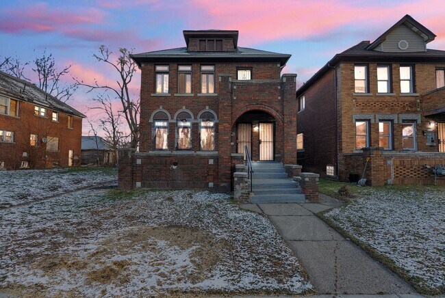
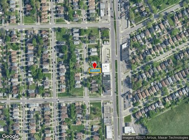
Property Record
12346 Stoepel St, Detroit, MI 48204

NEARBY LISTINGS FOR SALE OR LEASE
Property Detail
12346 Stoepel St
Detroit-Warren-Dearborn, MI
Robert Oakmans Ford Hwy & Glendale
16-018793
Wayne
Sfr
Michigan
X
0.09 AC
26163C0100E
North Detroit
2,600 SF
Detroit
DEMOGRAPHICS near 12346 Stoepel St
1 Mile
3 Mile
5 Mile
2024 Total Population
19,549
163,491
443,356
2029 Population
20,678
168,049
441,275
Pop Growth 2024-2029
+ 5.78%
+ 2.79%
(0.47%)
Average Age
39
38
37
2024 Total Households
8,209
64,685
168,432
HH Growth 2024-2029
+ 5.86%
+ 3.09%
(0.09%)
Median Household Inc
$32,229
$32,070
$36,162
Avg Household Size
2.30
2.40
2.50
2024 Avg HH Vehicles
1.00
1.00
1.00
Median Home Value
$83,528
$81,035
$90,184
Median Year Built
1946
1947
1948
Nearby Places
Map Layers
Map Styles
 Street
 Aerial
- Restaurants
- Banks
- Shops
- Fitness
- Groceries
PUBLIC TRANSPORTATION
COMMUTER RAIL
DRIVE
WALK
Distance
11 min
5.6 mi
AIRPORT
Windsor International
DRIVE
WALK
Distance
Windsor International
33 min
16.9 mi
Detroit Metro Wayne County
DRIVE
WALK
Distance
Detroit Metro Wayne County
34 min
21.0 mi
Freight Ports
DRIVE
WALK
Distance
79 min
63.4 mi
SALE & LEASE HISTORY
LISTING DATE
SALE/LEASE

Jan 07, 2025
For Sale
Nearby Properties
Address
Land Use
TOTAL SIZE
Lot Size
Zoning
Address
Land Use
TOTAL SIZE
Lot Size
Zoning
266,016 SF
7.76 AC
PD
Address
Land Use
TOTAL SIZE
Lot Size
Zoning
783,976 SF
52.57 AC
M4
Address
Land Use
TOTAL SIZE
Lot Size
Zoning
164,797 SF
2.03 AC
Address
Land Use
TOTAL SIZE
Lot Size
Zoning
171,665 SF
3.73 AC
R5
Address
Land Use
TOTAL SIZE
Lot Size
Zoning
520,522 SF
51.78 AC
M4
Address
Land Use
TOTAL SIZE
Lot Size
Zoning
590,652 SF
21.79 AC
TM
Address
Land Use
TOTAL SIZE
Lot Size
Zoning
446,500 SF
27.90 AC
Address
Land Use
TOTAL SIZE
Lot Size
Zoning
150,689 SF
4.87 AC
R5
Address
Land Use
TOTAL SIZE
Lot Size
Zoning
1,452 SF
19.24 AC
IC
Address
Land Use
TOTAL SIZE
Lot Size
Zoning
483,165 SF
22.98 AC
IB
Address
Land Use
TOTAL SIZE
Lot Size
Zoning
500,072 SF
12.50 AC
SD2
Address
Land Use
TOTAL SIZE
Lot Size
Zoning
336,958 SF
15.54 AC
IB
Address
Land Use
TOTAL SIZE
Lot Size
Zoning
63,216 SF
2.87 AC
R5
Address
Land Use
TOTAL SIZE
Lot Size
Zoning
66,870 SF
2.77 AC
Address
Land Use
TOTAL SIZE
Lot Size
Zoning
331,590 SF
18.50 AC
M4
Address
Land Use
TOTAL SIZE
Lot Size
Zoning
402,213 SF
16.50 AC
M3
Address
Land Use
TOTAL SIZE
Lot Size
Zoning
315,973 SF
12.18 AC
M4
Address
Land Use
TOTAL SIZE
Lot Size
Zoning
110,000 SF
1.36 AC
Address
Land Use
TOTAL SIZE
Lot Size
Zoning
7.10 AC
Address
Land Use
TOTAL SIZE
Lot Size
Zoning
91,233 SF
11.36 AC
Address
Land Use
TOTAL SIZE
Lot Size
Zoning
143,100 SF
3.14 AC
IC
Address
Land Use
TOTAL SIZE
Lot Size
Zoning
75,228 SF
0.34 AC
B4
Address
Land Use
TOTAL SIZE
Lot Size
Zoning
Address
Land Use
TOTAL SIZE
Lot Size
Zoning
155,532 SF
1.72 AC
Address
Land Use
TOTAL SIZE
Lot Size
Zoning
256,564 SF
M4
Address
Land Use
TOTAL SIZE
Lot Size
Zoning
74,029 SF
6.44 AC
B3
Address
Land Use
TOTAL SIZE
Lot Size
Zoning
68,729 SF
0.52 AC
B4
Address
Land Use
TOTAL SIZE
Lot Size
Zoning
44,442 SF
3.15 AC
PD
Address
Land Use
TOTAL SIZE
Lot Size
Zoning
32,227 SF
0.27 AC
R5
Address
Land Use
TOTAL SIZE
Lot Size
Zoning
46,292 SF
2.76 AC
R1
The World's #1 Commercial Real Estate Marketplace
Connect with us
© 2025 CoStar Group
The information above has been obtained from sources believed reliable. While we do not doubt its accuracy we have not verified it and make no guarantee, warranty or representation about it. It is your responsibility to independently confirm its accuracy and completeness. Any projections, opinions, assumptions, or estimates used are for example only and do not represent the current or future performance of the property. The value of this transaction to you depends on tax and other factors which should be evaluated by your tax, financial, and legal advisors. You and your advisors should conduct a careful, independent investigation of the property to determine to your satisfaction the suitability of the property for your needs.