Property Record
1235 W Burnside St, Portland, OR 97209

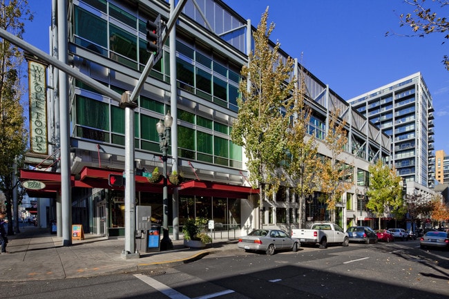
Property Detail
1235 W Burnside St
R732417
BREWERY BLOCK CONDOMINIUM, UNIT 6
Commercialcondominium
MULTNOMAH
2025
Oregon
2025
CBD
005001
Portland
2,767 SF
Portland-Vancouver-Hillsboro, OR-WA
NEARBY LISTINGS FOR SALE OR LEASE
DEMOGRAPHICS near 1235 W Burnside St
1 mile
3 mile
5 mile
2025 Total Population
51,178
183,284
425,884
2030 Population
51,541
183,475
423,117
Pop Growth 2025-2030
+ 0.71%
+ 0.10%
(0.65%)
Average Age
41
41
41
2025 Total Households
31,939
96,643
197,894
HH Growth 2025-2030
+ 0.49%
+ 0.06%
(0.71%)
Median Household Inc
$62,580
$87,009
$97,773
Avg Household Size
1.50
1.80
2.00
2025 Avg HH Vehicles
1.00
1.00
1.00
Median Home Value
$699,215
$764,114
$720,873
Median Year Built
1990
1972
1962
Nearby Places
Map Layers
Map Styles
 Street
 Aerial
Transit
 Traffic
 Biking
Places
Listings with unknown addresses are not visible on the map
- Restaurants
- Banks
- Shops
- Fitness
- Groceries
PUBLIC TRANSPORTATION
TRANSIT/SUBWAY
NW 11th & Couch (Portland Streetcar - Tri-County Metropolitan Transportation District of Oregon Rail (TriMet Rail))
Drive
Walk
Distance
NW 11th & Couch (Portland Streetcar - Tri-County Metropolitan Transportation District of Oregon Rail (TriMet Rail))
1 min
2 min
0.1 mi
NW 10th & Couch (Portland Streetcar - Tri-County Metropolitan Transportation District of Oregon Rail (TriMet Rail))
Drive
Walk
Distance
NW 10th & Couch (Portland Streetcar - Tri-County Metropolitan Transportation District of Oregon Rail (TriMet Rail))
1 min
4 min
0.2 mi
SW 10th & Stark (Portland Streetcar - Tri-County Metropolitan Transportation District of Oregon Rail (TriMet Rail))
Drive
Walk
Distance
SW 10th & Stark (Portland Streetcar - Tri-County Metropolitan Transportation District of Oregon Rail (TriMet Rail))
2 min
4 min
0.2 mi
NW 10th & Everett (Portland Streetcar - Tri-County Metropolitan Transportation District of Oregon Rail (TriMet Rail))
Drive
Walk
Distance
NW 10th & Everett (Portland Streetcar - Tri-County Metropolitan Transportation District of Oregon Rail (TriMet Rail))
1 min
5 min
0.3 mi
SW 10th & Alder (Portland Streetcar - Tri-County Metropolitan Transportation District of Oregon Rail (TriMet Rail))
Drive
Walk
Distance
SW 10th & Alder (Portland Streetcar - Tri-County Metropolitan Transportation District of Oregon Rail (TriMet Rail))
2 min
6 min
0.3 mi
COMMUTER RAIL
Drive
Walk
Distance
3 min
14 min
0.7 mi
Beaverton Transit Center (West Side Express) (Westside Express Service - Tri-County Metropolitan Transportation District of Oregon Rail (TriMet Rail))
Drive
Walk
Distance
Beaverton Transit Center (West Side Express) (Westside Express Service - Tri-County Metropolitan Transportation District of Oregon Rail (TriMet Rail))
15 min
7.8 mi
AIRPORT
Portland International
Drive
Walk
Distance
Portland International
22 min
11.2 mi
SALE & LEASE HISTORY
LISTING DATE
SALE/LEASE

Sep 25, 2016
For Lease
Sep 12, 2023
For Lease
Sep 12, 2022
For Lease
Sep 01, 2017
For Lease
Oct 17, 2022
For Lease
Jul 25, 2017
For Lease
Jul 08, 2020
For Lease
Aug 31, 2017
For Lease
Nearby Properties
Address
Land Use
TOTAL SIZE
Lot Size
Zoning
Address
Land Use
TOTAL SIZE
Lot Size
Zoning
395,815 SF
2.66 AC
IRD
Address
Land Use
TOTAL SIZE
Lot Size
Zoning
27.58 AC
EX
Address
Land Use
TOTAL SIZE
Lot Size
Zoning
627,500 SF
16.60 AC
CX
Address
Land Use
TOTAL SIZE
Lot Size
Zoning
57,314 SF
60.69 AC
OS
Address
Land Use
TOTAL SIZE
Lot Size
Zoning
560,000 SF
0.15 AC
CX
Address
Land Use
TOTAL SIZE
Lot Size
Zoning
20.71 AC
OS
Address
Land Use
TOTAL SIZE
Lot Size
Zoning
409,260 SF
7.41 AC
EX
Address
Land Use
TOTAL SIZE
Lot Size
Zoning
1.09 AC
EX
Address
Land Use
TOTAL SIZE
Lot Size
Zoning
2.24 AC
CX
Address
Land Use
TOTAL SIZE
Lot Size
Zoning
326,547 SF
2.42 AC
RH
Address
Land Use
TOTAL SIZE
Lot Size
Zoning
304,836 SF
10.85 AC
CX
Address
Land Use
TOTAL SIZE
Lot Size
Zoning
417,324 SF
0.68 AC
CX
Address
Land Use
TOTAL SIZE
Lot Size
Zoning
598,328 SF
12.32 AC
CX
Address
Land Use
TOTAL SIZE
Lot Size
Zoning
257,700 SF
2.89 AC
EX
Address
Land Use
TOTAL SIZE
Lot Size
Zoning
178,785 SF
10.20 AC
R5
Address
Land Use
TOTAL SIZE
Lot Size
Zoning
128,500 SF
6.95 AC
OS
Address
Land Use
TOTAL SIZE
Lot Size
Zoning
460,000 SF
0.92 AC
CX
Address
Land Use
TOTAL SIZE
Lot Size
Zoning
689,840 SF
0.92 AC
CX
Address
Land Use
TOTAL SIZE
Lot Size
Zoning
125,217 SF
0.23 AC
CX
Address
Land Use
TOTAL SIZE
Lot Size
Zoning
97,465 SF
107.18 AC
OS
Address
Land Use
TOTAL SIZE
Lot Size
Zoning
7.78 AC
EX
Address
Land Use
TOTAL SIZE
Lot Size
Zoning
426,742 SF
0.53 AC
RXD
Address
Land Use
TOTAL SIZE
Lot Size
Zoning
243,371 SF
0.67 AC
CI2
Address
Land Use
TOTAL SIZE
Lot Size
Zoning
584,483 SF
0.90 AC
CX
Address
Land Use
TOTAL SIZE
Lot Size
Zoning
645,294 SF
5.64 AC
CO2D
Address
Land Use
TOTAL SIZE
Lot Size
Zoning
247,520 SF
7.74 AC
CX
Address
Land Use
TOTAL SIZE
Lot Size
Zoning
306,000 SF
1.21 AC
NULL
Address
Land Use
TOTAL SIZE
Lot Size
Zoning
596,161 SF
0.92 AC
CX
Address
Land Use
TOTAL SIZE
Lot Size
Zoning
456,760 SF
0.53 AC
EX
Address
Land Use
TOTAL SIZE
Lot Size
Zoning
193,898 SF
2.50 AC
IRD
The World's #1 Commercial Real Estate Marketplace
Connect with us
© 2026 CoStar Group
The information above has been obtained from sources believed reliable. While we do not doubt its accuracy we have not verified it and make no guarantee, warranty or representation about it. It is your responsibility to independently confirm its accuracy and completeness. Any projections, opinions, assumptions, or estimates used are for example only and do not represent the current or future performance of the property. The value of this transaction to you depends on tax and other factors which should be evaluated by your tax, financial, and legal advisors. You and your advisors should conduct a careful, independent investigation of the property to determine to your satisfaction the suitability of the property for your needs.