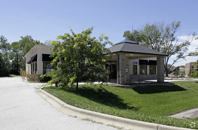
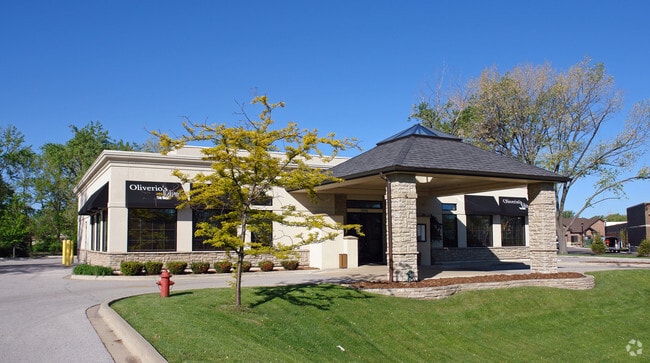
Property Record
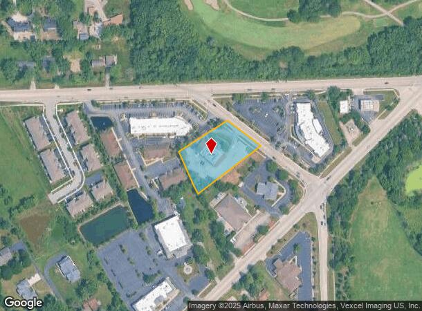
12350 Derby Rd, Lemont, IL 60439

NEARBY LISTINGS FOR SALE OR LEASE
-
-
View all Lemont listings for sale on LoopNet.com
Property Detail
12350 Derby Rd
22-27-300-022-0000
Baileys Xing
Commercialbuilding
Cook
X
Illinois
17043C0287J
21
2023
1.14 AC
2024
Joliet/Central Will
824003
Chicago
4,158 SF
Chicago-Naperville-Elgin, IL-IN-WI
DEMOGRAPHICS near 12350 Derby Rd
1 Mile
3 Mile
5 Mile
2024 Total Population
4,757
29,955
74,163
2029 Population
4,613
29,277
72,742
Pop Growth 2024-2029
(3.03%)
(2.26%)
(1.92%)
Average Age
45
44
43
2024 Total Households
1,658
10,775
26,517
HH Growth 2024-2029
(3.38%)
(2.50%)
(2.10%)
Median Household Inc
$113,124
$117,215
$109,416
Avg Household Size
2.70
2.70
2.70
2024 Avg HH Vehicles
2.00
2.00
2.00
Median Home Value
$451,857
$390,929
$380,500
Median Year Built
1994
1989
1988
Nearby Places
Map Layers
Map Styles
 Street
 Aerial
- Restaurants
- Banks
- Shops
- Fitness
- Groceries
PUBLIC TRANSPORTATION
COMMUTER RAIL
Lemont Station (Heritage Corridor Line - Northeast Illinois Regional Commuter Railroad (Metra))
DRIVE
WALK
Distance
Lemont Station (Heritage Corridor Line - Northeast Illinois Regional Commuter Railroad (Metra))
5 min
2.2 mi
DRIVE
WALK
Distance
13 min
6.3 mi
AIRPORT
Chicago Midway International
DRIVE
WALK
Distance
Chicago Midway International
27 min
17.8 mi
Chicago O'Hare International
DRIVE
WALK
Distance
Chicago O'Hare International
44 min
29.2 mi
Nearby Properties
Address
Land Use
TOTAL SIZE
Lot Size
Zoning
Address
Land Use
TOTAL SIZE
Lot Size
Zoning
18.82 AC
Address
Land Use
TOTAL SIZE
Lot Size
Zoning
20.43 AC
Address
Land Use
TOTAL SIZE
Lot Size
Zoning
8,577 SF
160 AC
Address
Land Use
TOTAL SIZE
Lot Size
Zoning
13.73 AC
Address
Land Use
TOTAL SIZE
Lot Size
Zoning
24.85 AC
Address
Land Use
TOTAL SIZE
Lot Size
Zoning
166,107 SF
16.17 AC
Address
Land Use
TOTAL SIZE
Lot Size
Zoning
97,113 SF
44.53 AC
Address
Land Use
TOTAL SIZE
Lot Size
Zoning
70,848 SF
8.40 AC
Address
Land Use
TOTAL SIZE
Lot Size
Zoning
74,782 SF
5.15 AC
Address
Land Use
TOTAL SIZE
Lot Size
Zoning
15.21 AC
Address
Land Use
TOTAL SIZE
Lot Size
Zoning
67,229 SF
8.83 AC
Address
Land Use
TOTAL SIZE
Lot Size
Zoning
122,052 SF
11.61 AC
Address
Land Use
TOTAL SIZE
Lot Size
Zoning
119,012 SF
10.84 AC
Address
Land Use
TOTAL SIZE
Lot Size
Zoning
103,164 SF
10.87 AC
Address
Land Use
TOTAL SIZE
Lot Size
Zoning
38,882 SF
4.79 AC
Address
Land Use
TOTAL SIZE
Lot Size
Zoning
8.24 AC
Address
Land Use
TOTAL SIZE
Lot Size
Zoning
20,068 SF
24.55 AC
Address
Land Use
TOTAL SIZE
Lot Size
Zoning
38,950 SF
4.82 AC
Address
Land Use
TOTAL SIZE
Lot Size
Zoning
1.96 AC
Address
Land Use
TOTAL SIZE
Lot Size
Zoning
74,888 SF
Address
Land Use
TOTAL SIZE
Lot Size
Zoning
86,814 SF
8.91 AC
Address
Land Use
TOTAL SIZE
Lot Size
Zoning
2.07 AC
Address
Land Use
TOTAL SIZE
Lot Size
Zoning
4.19 AC
Address
Land Use
TOTAL SIZE
Lot Size
Zoning
1.09 AC
Address
Land Use
TOTAL SIZE
Lot Size
Zoning
1.06 AC
Address
Land Use
TOTAL SIZE
Lot Size
Zoning
Address
Land Use
TOTAL SIZE
Lot Size
Zoning
1,625 SF
0.82 AC
Address
Land Use
TOTAL SIZE
Lot Size
Zoning
33.02 AC
Address
Land Use
TOTAL SIZE
Lot Size
Zoning
9,518 SF
1.03 AC
Address
Land Use
TOTAL SIZE
Lot Size
Zoning
7,306 SF
1.80 AC
The World's #1 Commercial Real Estate Marketplace
Connect with us
© 2025 CoStar Group
The information above has been obtained from sources believed reliable. While we do not doubt its accuracy we have not verified it and make no guarantee, warranty or representation about it. It is your responsibility to independently confirm its accuracy and completeness. Any projections, opinions, assumptions, or estimates used are for example only and do not represent the current or future performance of the property. The value of this transaction to you depends on tax and other factors which should be evaluated by your tax, financial, and legal advisors. You and your advisors should conduct a careful, independent investigation of the property to determine to your satisfaction the suitability of the property for your needs.