Property Record
12355 Doris Rd, Parrish, FL 34219


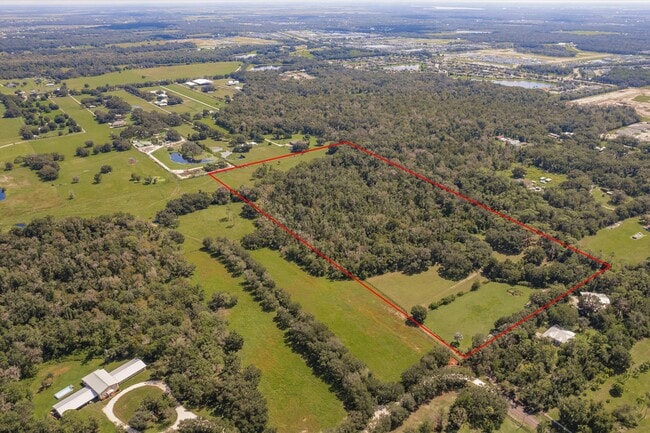
Property Detail
12355 Doris Rd
4807-0005-3
BEG AT THE NE COR OF SD SE1/4 OF THE NE1/4; TH S 00 DEG 16 MIN 39 SEC W, ALG THE E LN OF SD SE1/4 OF THE NE1/4, 757.81 FT; TH N 87 DEG 54 MIN 39 SEC W, 1340.27 FT TO THE W LN OF
Vacantlandnec
MANATEE
A-1 SUBURB
Florida
AE The base floodplain where base flood elevations are provided. AE Zones are now used on new format FIRMs instead of A1-A30 Zones.
22.25 AC
2023
Manatee
2025
Tampa/St Petersburg
001913
North Port-Bradenton-Sarasota, FL
NEARBY LISTINGS FOR SALE OR LEASE
DEMOGRAPHICS near 12355 Doris Rd
1 mile
3 mile
5 mile
2024 Total Population
1,914
24,353
53,892
2029 Population
2,184
28,271
62,375
Pop Growth 2024-2029
+ 14.11%
+ 16.09%
+ 15.74%
Average Age
42
44
47
2024 Total Households
673
8,922
20,925
HH Growth 2024-2029
+ 12.78%
+ 14.94%
+ 14.91%
Median Household Inc
$108,602
$102,170
$92,272
Avg Household Size
2.70
2.60
2.50
2024 Avg HH Vehicles
2.00
2.00
2.00
Median Home Value
$351,970
$336,738
$342,346
Median Year Built
2008
2008
2007
Nearby Places
Map Layers
Map Styles
 Street
 Aerial
Transit
 Traffic
 Biking
Places
Listings with unknown addresses are not visible on the map
- Restaurants
- Banks
- Shops
- Fitness
- Groceries
PUBLIC TRANSPORTATION
AIRPORT
Sarasota/Bradenton International
Drive
Walk
Distance
Sarasota/Bradenton International
39 min
20.0 mi
St Pete-Clearwater International
Drive
Walk
Distance
St Pete-Clearwater International
61 min
41.4 mi
Tampa International
Drive
Walk
Distance
Tampa International
66 min
43.2 mi
Freight Ports
Port Manatee
Drive
Walk
Distance
Port Manatee
24 min
12.5 mi
Nearby Properties
Address
Land Use
TOTAL SIZE
Lot Size
Zoning
Address
Land Use
TOTAL SIZE
Lot Size
Zoning
47.43 AC
Address
Land Use
TOTAL SIZE
Lot Size
Zoning
136.89 AC
Address
Land Use
TOTAL SIZE
Lot Size
Zoning
66,063 SF
9.24 AC
PD-C
Address
Land Use
TOTAL SIZE
Lot Size
Zoning
43,464 SF
14.47 AC
VIL VILLAG
Address
Land Use
TOTAL SIZE
Lot Size
Zoning
190.90 AC
PD-R
Address
Land Use
TOTAL SIZE
Lot Size
Zoning
50,580 SF
5.97 AC
Address
Land Use
TOTAL SIZE
Lot Size
Zoning
53,851 SF
6.32 AC
Address
Land Use
TOTAL SIZE
Lot Size
Zoning
30,101 SF
13.44 AC
PD-C
Address
Land Use
TOTAL SIZE
Lot Size
Zoning
76.98 AC
Address
Land Use
TOTAL SIZE
Lot Size
Zoning
36,700 SF
17 AC
A-1 SUBURB
Address
Land Use
TOTAL SIZE
Lot Size
Zoning
109.06 AC
Address
Land Use
TOTAL SIZE
Lot Size
Zoning
3.11 AC
Address
Land Use
TOTAL SIZE
Lot Size
Zoning
4.07 AC
Address
Land Use
TOTAL SIZE
Lot Size
Zoning
53,448 SF
3 AC
PD-C
Address
Land Use
TOTAL SIZE
Lot Size
Zoning
44.29 AC
Address
Land Use
TOTAL SIZE
Lot Size
Zoning
25,842 SF
3.92 AC
Address
Land Use
TOTAL SIZE
Lot Size
Zoning
9,806 SF
4.04 AC
VIL VILLAG
Address
Land Use
TOTAL SIZE
Lot Size
Zoning
17,677 SF
9.52 AC
A-1 SUBURB
Address
Land Use
TOTAL SIZE
Lot Size
Zoning
113.80 AC
Address
Land Use
TOTAL SIZE
Lot Size
Zoning
3,604 SF
42.10 AC
A GENERAL
Address
Land Use
TOTAL SIZE
Lot Size
Zoning
7.54 AC
Address
Land Use
TOTAL SIZE
Lot Size
Zoning
293,048 SF
42.24 AC
A-1 SUBURB
Address
Land Use
TOTAL SIZE
Lot Size
Zoning
10,303 SF
1.26 AC
PD-MU
Address
Land Use
TOTAL SIZE
Lot Size
Zoning
0.15 AC
PDR
Address
Land Use
TOTAL SIZE
Lot Size
Zoning
1,412 SF
2.16 AC
PD-R
Address
Land Use
TOTAL SIZE
Lot Size
Zoning
34,824 SF
192.28 AC
PD-R
Address
Land Use
TOTAL SIZE
Lot Size
Zoning
1.96 AC
Address
Land Use
TOTAL SIZE
Lot Size
Zoning
50.40 AC
PD-MU
Address
Land Use
TOTAL SIZE
Lot Size
Zoning
191.62 AC
PD-MU
Address
Land Use
TOTAL SIZE
Lot Size
Zoning
12,669 SF
2.49 AC
VIL VILLAG
The World's #1 Commercial Real Estate Marketplace
Connect with us
© 2026 CoStar Group
The information above has been obtained from sources believed reliable. While we do not doubt its accuracy we have not verified it and make no guarantee, warranty or representation about it. It is your responsibility to independently confirm its accuracy and completeness. Any projections, opinions, assumptions, or estimates used are for example only and do not represent the current or future performance of the property. The value of this transaction to you depends on tax and other factors which should be evaluated by your tax, financial, and legal advisors. You and your advisors should conduct a careful, independent investigation of the property to determine to your satisfaction the suitability of the property for your needs.