Property Record
1236 Arbour Point Way, Ocoee, FL 34761
NEARBY LISTINGS FOR SALE OR LEASE
-
-
View all Ocoee listings for sale on LoopNet.com
Property Detail
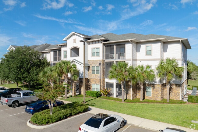
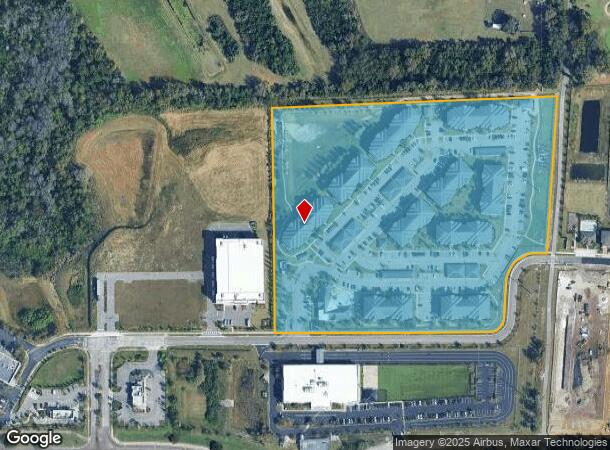
1236 Arbour Point Way
Orlando-Kissimmee-Sanford, FL
Arbours At Crown Point
06-2228-0150-01-000
ARBOURS AT CROWN POINT 94/88 LOT 1
Multifamilydwelling
Orange
X
Florida
12095C0210H
1
2024
16.38 AC
2025
Lake Apopka
017506
Orlando
286,493 SF
DEMOGRAPHICS near 1236 Arbour Point Way
1 Mile
3 Mile
5 Mile
2024 Total Population
6,677
43,924
143,771
2029 Population
6,910
45,428
148,406
Pop Growth 2024-2029
+ 3.49%
+ 3.42%
+ 3.22%
Average Age
38
38
39
2024 Total Households
2,128
14,415
48,539
HH Growth 2024-2029
+ 3.62%
+ 3.46%
+ 3.24%
Median Household Inc
$91,939
$79,565
$61,093
Avg Household Size
3.10
3.00
2.90
2024 Avg HH Vehicles
2.00
2.00
2.00
Median Home Value
$359,406
$318,454
$282,614
Median Year Built
2004
1996
1992
Nearby Places
Map Layers
Map Styles
 Street
 Aerial
- Restaurants
- Banks
- Shops
- Fitness
- Groceries
PUBLIC TRANSPORTATION
AIRPORT
Orlando International
DRIVE
WALK
Distance
Orlando International
37 min
26.1 mi
Orlando Sanford International
DRIVE
WALK
Distance
Orlando Sanford International
48 min
32.4 mi
Freight Ports
Port Canaveral
DRIVE
WALK
Distance
Port Canaveral
84 min
68.7 mi
Nearby Properties
Address
Land Use
TOTAL SIZE
Lot Size
Zoning
Address
Land Use
TOTAL SIZE
Lot Size
Zoning
669,041 SF
43.79 AC
I-1
Address
Land Use
TOTAL SIZE
Lot Size
Zoning
321,759 SF
PUD-HD
Address
Land Use
TOTAL SIZE
Lot Size
Zoning
668,180 SF
52.21 AC
PUD-PU
Address
Land Use
TOTAL SIZE
Lot Size
Zoning
361,418 SF
18.88 AC
MU-ES-GT
Address
Land Use
TOTAL SIZE
Lot Size
Zoning
368,910 SF
14.02 AC
CAPUD
Address
Land Use
TOTAL SIZE
Lot Size
Zoning
314,897 SF
21.59 AC
PD
Address
Land Use
TOTAL SIZE
Lot Size
Zoning
446,425 SF
25.15 AC
PUD-IND
Address
Land Use
TOTAL SIZE
Lot Size
Zoning
243,832 SF
28.69 AC
MU-ES-GT
Address
Land Use
TOTAL SIZE
Lot Size
Zoning
314,643 SF
38.04 AC
PUD
Address
Land Use
TOTAL SIZE
Lot Size
Zoning
196,924 SF
2.53 AC
P-S
Address
Land Use
TOTAL SIZE
Lot Size
Zoning
179,371 SF
21.52 AC
A-1
Address
Land Use
TOTAL SIZE
Lot Size
Zoning
198,752 SF
38.50 AC
I-L
Address
Land Use
TOTAL SIZE
Lot Size
Zoning
60,028 SF
1,047.57 AC
A-1
Address
Land Use
TOTAL SIZE
Lot Size
Zoning
107,978 SF
9.76 AC
MU-ES-GT
Address
Land Use
TOTAL SIZE
Lot Size
Zoning
157,634 SF
16.29 AC
A-1
Address
Land Use
TOTAL SIZE
Lot Size
Zoning
55,594 SF
3.02 AC
PUD-IND
Address
Land Use
TOTAL SIZE
Lot Size
Zoning
181,355 SF
30.79 AC
A-1
Address
Land Use
TOTAL SIZE
Lot Size
Zoning
76,416 SF
8.82 AC
PUD-COMM
Address
Land Use
TOTAL SIZE
Lot Size
Zoning
61,433 SF
18.28 AC
I-2
Address
Land Use
TOTAL SIZE
Lot Size
Zoning
41,958 SF
40.10 AC
I-2
Address
Land Use
TOTAL SIZE
Lot Size
Zoning
47,912 SF
1.05 AC
C-2
Address
Land Use
TOTAL SIZE
Lot Size
Zoning
80,640 SF
7.14 AC
C-2
Address
Land Use
TOTAL SIZE
Lot Size
Zoning
44,681 SF
4.23 AC
PUD-IND
Address
Land Use
TOTAL SIZE
Lot Size
Zoning
83,191 SF
16.03 AC
A-1
Address
Land Use
TOTAL SIZE
Lot Size
Zoning
103,811 SF
12.78 AC
C-2
Address
Land Use
TOTAL SIZE
Lot Size
Zoning
102,128 SF
1.88 AC
PUD-COMM
Address
Land Use
TOTAL SIZE
Lot Size
Zoning
69,977 SF
5.30 AC
PUD
Address
Land Use
TOTAL SIZE
Lot Size
Zoning
57,596 SF
5.42 AC
PUD-COMM
Address
Land Use
TOTAL SIZE
Lot Size
Zoning
68,365 SF
5.80 AC
PUD
The World's #1 Commercial Real Estate Marketplace
Connect with us
© 2025 CoStar Group
The information above has been obtained from sources believed reliable. While we do not doubt its accuracy we have not verified it and make no guarantee, warranty or representation about it. It is your responsibility to independently confirm its accuracy and completeness. Any projections, opinions, assumptions, or estimates used are for example only and do not represent the current or future performance of the property. The value of this transaction to you depends on tax and other factors which should be evaluated by your tax, financial, and legal advisors. You and your advisors should conduct a careful, independent investigation of the property to determine to your satisfaction the suitability of the property for your needs.