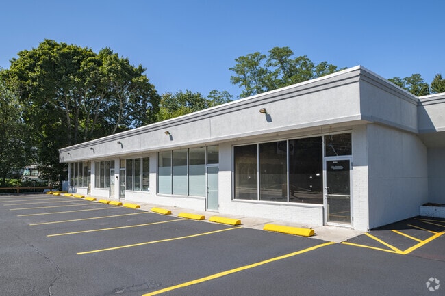
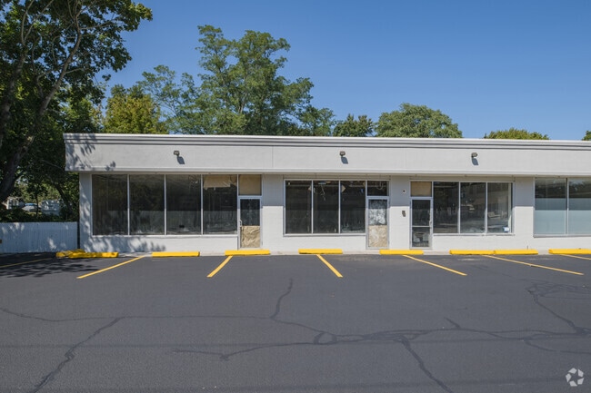
Property Record
1237 W Shore Rd, Warwick, RI 02889

Current Lease Availabilities
Property Detail
1237 W Shore Rd
Commercialbuilding
Kent
GB
Rhode Island
AE The base floodplain where base flood elevations are provided. AE Zones are now used on new format FIRMs instead of A1-A30 Zones.
0.43 AC
2025
Warwick
2025
Providence
021501
Providence-Warwick, RI-MA
4,404 SF
WARW-000332-000016-000000
NEARBY LISTINGS FOR SALE OR LEASE
DEMOGRAPHICS near 1237 W Shore Rd
1 mile
3 mile
5 mile
2025 Total Population
8,948
45,372
128,591
2030 Population
9,007
45,820
130,607
Pop Growth 2025-2030
+ 0.66%
+ 0.99%
+ 1.57%
Average Age
43
44
44
2025 Total Households
3,741
19,183
53,619
HH Growth 2025-2030
+ 0.72%
+ 1.02%
+ 1.62%
Median Household Inc
$78,518
$92,507
$93,875
Avg Household Size
2.30
2.30
2.30
2025 Avg HH Vehicles
2.00
2.00
2.00
Median Home Value
$343,193
$359,964
$380,567
Median Year Built
1957
1957
1957
Nearby Places
Map Layers
Map Styles
 Street
 Aerial
Layers
 Traffic
 Biking
Places
Listings with unknown addresses are not visible on the map
- Restaurants
- Banks
- Shops
- Fitness
- Groceries
PUBLIC TRANSPORTATION
COMMUTER RAIL
Drive
Walk
Distance
10 min
5.0 mi
Providence (Providence/Stoughton Line - Massachusetts Bay Transportation Authority Commuter Rail (Purple Line))
Drive
Walk
Distance
Providence (Providence/Stoughton Line - Massachusetts Bay Transportation Authority Commuter Rail (Purple Line))
17 min
9.7 mi
AIRPORT
Rhode Island Tf Green International
Drive
Walk
Distance
Rhode Island Tf Green International
9 min
3.9 mi
Nearby Properties
Address
Land Use
TOTAL SIZE
Lot Size
Zoning
Address
Land Use
TOTAL SIZE
Lot Size
Zoning
40,385 SF
70 AC
A40
Address
Land Use
TOTAL SIZE
Lot Size
Zoning
228,067 SF
30.74 AC
A7
Address
Land Use
TOTAL SIZE
Lot Size
Zoning
491,496 SF
46.72 AC
LI
Address
Land Use
TOTAL SIZE
Lot Size
Zoning
247,671 SF
10.78 AC
A7
Address
Land Use
TOTAL SIZE
Lot Size
Zoning
135,317 SF
27.16 AC
A10
Address
Land Use
TOTAL SIZE
Lot Size
Zoning
110,031 SF
5.07 AC
EH
Address
Land Use
TOTAL SIZE
Lot Size
Zoning
73,193 SF
19.87 AC
A10
Address
Land Use
TOTAL SIZE
Lot Size
Zoning
19,584 SF
A10
Address
Land Use
TOTAL SIZE
Lot Size
Zoning
24,865 SF
A7
Address
Land Use
TOTAL SIZE
Lot Size
Zoning
4,288 SF
10.23 AC
GB
Address
Land Use
TOTAL SIZE
Lot Size
Zoning
5.40 AC
WB
Address
Land Use
TOTAL SIZE
Lot Size
Zoning
18,876 SF
44.45 AC
A7
Address
Land Use
TOTAL SIZE
Lot Size
Zoning
48,800 SF
78.50 AC
A15
Address
Land Use
TOTAL SIZE
Lot Size
Zoning
12,240 SF
A10
Address
Land Use
TOTAL SIZE
Lot Size
Zoning
20,768 SF
13.04 AC
A10
Address
Land Use
TOTAL SIZE
Lot Size
Zoning
18,032 SF
4.37 AC
A7
Address
Land Use
TOTAL SIZE
Lot Size
Zoning
67,252 SF
6.60 AC
A10
Address
Land Use
TOTAL SIZE
Lot Size
Zoning
39,041 SF
18.31 AC
GB
Address
Land Use
TOTAL SIZE
Lot Size
Zoning
79.02 AC
A7
Address
Land Use
TOTAL SIZE
Lot Size
Zoning
138.20 AC
RE
Address
Land Use
TOTAL SIZE
Lot Size
Zoning
23,600 SF
A10
Address
Land Use
TOTAL SIZE
Lot Size
Zoning
39,421 SF
A7
Address
Land Use
TOTAL SIZE
Lot Size
Zoning
36,047 SF
169.94 AC
OS
Address
Land Use
TOTAL SIZE
Lot Size
Zoning
55,178 SF
4.19 AC
A7
Address
Land Use
TOTAL SIZE
Lot Size
Zoning
74,980 SF
7.33 AC
GB
Address
Land Use
TOTAL SIZE
Lot Size
Zoning
52,440 SF
7.22 AC
A7
Address
Land Use
TOTAL SIZE
Lot Size
Zoning
2,704 SF
57.57 AC
A7
Address
Land Use
TOTAL SIZE
Lot Size
Zoning
37,092 SF
21.31 AC
A10
Address
Land Use
TOTAL SIZE
Lot Size
Zoning
167,067 SF
9.99 AC
LI
Address
Land Use
TOTAL SIZE
Lot Size
Zoning
33,805 SF
GB
The World's #1 Commercial Real Estate Marketplace
Connect with us
© 2026 CoStar Group
The information above has been obtained from sources believed reliable. While we do not doubt its accuracy we have not verified it and make no guarantee, warranty or representation about it. It is your responsibility to independently confirm its accuracy and completeness. Any projections, opinions, assumptions, or estimates used are for example only and do not represent the current or future performance of the property. The value of this transaction to you depends on tax and other factors which should be evaluated by your tax, financial, and legal advisors. You and your advisors should conduct a careful, independent investigation of the property to determine to your satisfaction the suitability of the property for your needs.