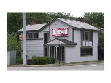
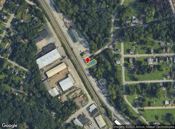
Property Record
1238 William Flynn Hwy, Glenshaw, PA 15116
NEARBY LISTINGS FOR SALE OR LEASE
Property Detail
1238 William Flynn Hwy
Pittsburgh, PA
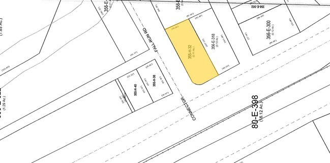
Willis Plan
0355-H-00032-0000-00
WILLIS PLAN #1 IRREG LOT= 42.01X109.10X45 (.11 ALD) RTE #8 COR FALL RUN RD 2 STY ALUM OFFICE BLDG
Retailwithmorethanonenonretailuse
Allegheny
AE
Pennsylvania
42003C0214H
32
2023
0.05 AC
2025
North Pittsburgh/Rte 19
426700
Pittsburgh
DEMOGRAPHICS near 1238 William Flynn Hwy
1 Mile
3 Mile
5 Mile
2024 Total Population
6,378
50,598
171,772
2029 Population
6,181
49,041
167,822
Pop Growth 2024-2029
(3.09%)
(3.08%)
(2.30%)
Average Age
46
44
42
2024 Total Households
2,833
21,666
78,490
HH Growth 2024-2029
(3.14%)
(3.12%)
(2.33%)
Median Household Inc
$84,651
$86,931
$77,007
Avg Household Size
2.20
2.30
2.10
2024 Avg HH Vehicles
2.00
2.00
2.00
Median Home Value
$232,336
$232,697
$246,741
Median Year Built
1960
1959
1955
Nearby Places
Map Layers
Map Styles
 Street
 Aerial
- Restaurants
- Banks
- Shops
- Fitness
- Groceries
PUBLIC TRANSPORTATION
COMMUTER RAIL
Pittsburgh Amtrak Station (Capitol Limited - Amtrak, Pennsylvanian - Amtrak)
DRIVE
WALK
Distance
Pittsburgh Amtrak Station (Capitol Limited - Amtrak, Pennsylvanian - Amtrak)
15 min
7.8 mi
AIRPORT
Pittsburgh International
DRIVE
WALK
Distance
Pittsburgh International
39 min
24.8 mi
Freight Ports
Port of Baltimore
DRIVE
WALK
Distance
Port of Baltimore
297 min
253.7 mi
Nearby Properties
Address
Land Use
TOTAL SIZE
Lot Size
Zoning
Address
Land Use
TOTAL SIZE
Lot Size
Zoning
0.67 AC
Address
Land Use
TOTAL SIZE
Lot Size
Zoning
80.99 AC
Address
Land Use
TOTAL SIZE
Lot Size
Zoning
19.84 AC
Address
Land Use
TOTAL SIZE
Lot Size
Zoning
3,711 SF
11.07 AC
Address
Land Use
TOTAL SIZE
Lot Size
Zoning
9.74 AC
Address
Land Use
TOTAL SIZE
Lot Size
Zoning
Address
Land Use
TOTAL SIZE
Lot Size
Zoning
18.25 AC
Address
Land Use
TOTAL SIZE
Lot Size
Zoning
22.51 AC
Address
Land Use
TOTAL SIZE
Lot Size
Zoning
12.69 AC
Address
Land Use
TOTAL SIZE
Lot Size
Zoning
28.23 AC
Address
Land Use
TOTAL SIZE
Lot Size
Zoning
11.03 AC
Address
Land Use
TOTAL SIZE
Lot Size
Zoning
12.70 AC
Address
Land Use
TOTAL SIZE
Lot Size
Zoning
Address
Land Use
TOTAL SIZE
Lot Size
Zoning
Address
Land Use
TOTAL SIZE
Lot Size
Zoning
Address
Land Use
TOTAL SIZE
Lot Size
Zoning
Address
Land Use
TOTAL SIZE
Lot Size
Zoning
16.35 AC
Address
Land Use
TOTAL SIZE
Lot Size
Zoning
28.16 AC
Address
Land Use
TOTAL SIZE
Lot Size
Zoning
11.97 AC
Address
Land Use
TOTAL SIZE
Lot Size
Zoning
Address
Land Use
TOTAL SIZE
Lot Size
Zoning
76.11 AC
Address
Land Use
TOTAL SIZE
Lot Size
Zoning
Address
Land Use
TOTAL SIZE
Lot Size
Zoning
Address
Land Use
TOTAL SIZE
Lot Size
Zoning
37.35 AC
Address
Land Use
TOTAL SIZE
Lot Size
Zoning
34.75 AC
Address
Land Use
TOTAL SIZE
Lot Size
Zoning
19.45 AC
Address
Land Use
TOTAL SIZE
Lot Size
Zoning
6.69 AC
Address
Land Use
TOTAL SIZE
Lot Size
Zoning
9.16 AC
Address
Land Use
TOTAL SIZE
Lot Size
Zoning
900 SF
86.45 AC
Address
Land Use
TOTAL SIZE
Lot Size
Zoning
The World's #1 Commercial Real Estate Marketplace
Connect with us
© 2025 CoStar Group
The information above has been obtained from sources believed reliable. While we do not doubt its accuracy we have not verified it and make no guarantee, warranty or representation about it. It is your responsibility to independently confirm its accuracy and completeness. Any projections, opinions, assumptions, or estimates used are for example only and do not represent the current or future performance of the property. The value of this transaction to you depends on tax and other factors which should be evaluated by your tax, financial, and legal advisors. You and your advisors should conduct a careful, independent investigation of the property to determine to your satisfaction the suitability of the property for your needs.