Property Record
12381 W Bellfort St, Stafford, TX 77477
NEARBY LISTINGS FOR SALE OR LEASE
Property Detail
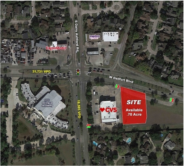
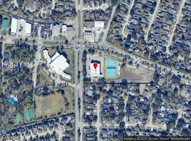
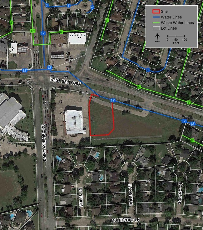
12381 W Bellfort St
Houston-The Woodlands-Sugar Land, TX
Jas Alston
0101-00-000-1606-907
0101 JAS ALSTON, ACRES 0.706, RESTRICTED RESERVE B, BLOCK 1, CVS MEADOWS PARK
Commercialnec
Fort Bend
X
Texas
48157C0165L
0.71 AC
2024
E Fort Bend Co/Sugar Land
2025
Houston
671900
DEMOGRAPHICS near 12381 W Bellfort St
1 Mile
3 Mile
5 Mile
2024 Total Population
23,362
160,133
404,187
2029 Population
25,278
171,801
435,616
Pop Growth 2024-2029
+ 8.20%
+ 7.29%
+ 7.78%
Average Age
38
37
38
2024 Total Households
7,539
53,374
138,782
HH Growth 2024-2029
+ 8.94%
+ 7.86%
+ 8.04%
Median Household Inc
$57,039
$50,351
$51,456
Avg Household Size
3.00
2.90
2.80
2024 Avg HH Vehicles
2.00
2.00
2.00
Median Home Value
$181,025
$186,429
$215,706
Median Year Built
1981
1983
1985
Nearby Places
Map Layers
Map Styles
 Street
 Aerial
- Restaurants
- Banks
- Shops
- Fitness
- Groceries
PUBLIC TRANSPORTATION
AIRPORT
William P Hobby
DRIVE
WALK
Distance
William P Hobby
38 min
23.7 mi
George Bush Intcntl/Houston
DRIVE
WALK
Distance
George Bush Intcntl/Houston
49 min
38.3 mi
Freight Ports
Port of Houston
DRIVE
WALK
Distance
Port of Houston
40 min
25.8 mi
SALE & LEASE HISTORY
LISTING DATE
SALE/LEASE

Sep 24, 2016
For Sale
Oct 11, 2016
For Sale
Mar 01, 2018
For Sale
Nearby Properties
Address
Land Use
TOTAL SIZE
Lot Size
Zoning
Address
Land Use
TOTAL SIZE
Lot Size
Zoning
7.46 AC
Address
Land Use
TOTAL SIZE
Lot Size
Zoning
12.98 AC
Address
Land Use
TOTAL SIZE
Lot Size
Zoning
11.58 AC
Address
Land Use
TOTAL SIZE
Lot Size
Zoning
12.08 AC
Address
Land Use
TOTAL SIZE
Lot Size
Zoning
627,632 SF
24.12 AC
Address
Land Use
TOTAL SIZE
Lot Size
Zoning
94,547 SF
13.59 AC
Address
Land Use
TOTAL SIZE
Lot Size
Zoning
816,006 SF
40.26 AC
Address
Land Use
TOTAL SIZE
Lot Size
Zoning
422,123 SF
39.85 AC
Address
Land Use
TOTAL SIZE
Lot Size
Zoning
32,520 SF
34.98 AC
Address
Land Use
TOTAL SIZE
Lot Size
Zoning
126,308 SF
16.95 AC
Address
Land Use
TOTAL SIZE
Lot Size
Zoning
76,385 SF
17.48 AC
Address
Land Use
TOTAL SIZE
Lot Size
Zoning
76,306 SF
15.84 AC
Address
Land Use
TOTAL SIZE
Lot Size
Zoning
12.22 AC
Address
Land Use
TOTAL SIZE
Lot Size
Zoning
61,006 SF
13.16 AC
X
Address
Land Use
TOTAL SIZE
Lot Size
Zoning
183,015 SF
9.91 AC
Address
Land Use
TOTAL SIZE
Lot Size
Zoning
154,586 SF
10.93 AC
SY
Address
Land Use
TOTAL SIZE
Lot Size
Zoning
19.55 AC
S
Address
Land Use
TOTAL SIZE
Lot Size
Zoning
291,196 SF
30.06 AC
SXY
Address
Land Use
TOTAL SIZE
Lot Size
Zoning
322,894 SF
17.51 AC
Address
Land Use
TOTAL SIZE
Lot Size
Zoning
259,117 SF
6.28 AC
YS
Address
Land Use
TOTAL SIZE
Lot Size
Zoning
218,755 SF
19.69 AC
MQY
Address
Land Use
TOTAL SIZE
Lot Size
Zoning
84,509 SF
13.06 AC
Y
Address
Land Use
TOTAL SIZE
Lot Size
Zoning
355,887 SF
13.89 AC
Address
Land Use
TOTAL SIZE
Lot Size
Zoning
75,978 SF
10.13 AC
Address
Land Use
TOTAL SIZE
Lot Size
Zoning
23.49 AC
SMN
Address
Land Use
TOTAL SIZE
Lot Size
Zoning
52,502 SF
13.60 AC
XYS
Address
Land Use
TOTAL SIZE
Lot Size
Zoning
226,700 SF
19.14 AC
M
Address
Land Use
TOTAL SIZE
Lot Size
Zoning
637,364 SF
11.57 AC
YQ
Address
Land Use
TOTAL SIZE
Lot Size
Zoning
329,954 SF
15.55 AC
SH
Address
Land Use
TOTAL SIZE
Lot Size
Zoning
719,540 SF
33.47 AC
YQX
The World's #1 Commercial Real Estate Marketplace
Connect with us
© 2025 CoStar Group
The information above has been obtained from sources believed reliable. While we do not doubt its accuracy we have not verified it and make no guarantee, warranty or representation about it. It is your responsibility to independently confirm its accuracy and completeness. Any projections, opinions, assumptions, or estimates used are for example only and do not represent the current or future performance of the property. The value of this transaction to you depends on tax and other factors which should be evaluated by your tax, financial, and legal advisors. You and your advisors should conduct a careful, independent investigation of the property to determine to your satisfaction the suitability of the property for your needs.