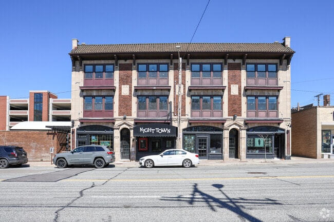
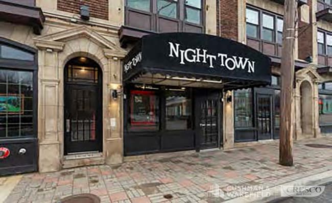
Property Record
12383 Cedar Rd, Cleveland, OH 44106

Current Lease Availabilities
Property Detail
12383 Cedar Rd
685-18-021
VOL 374 PG 62 PCL A FF 107.10 D 116.62 0.2980 AC 405 OL 2014 SR
Retailwithmorethanonenonretailuse
Cuyahoga
S2
Ohio
B and X Area of moderate flood hazard, usually the area between the limits of the 100-year and 500-year floods.
2
2025
0.30 AC
2025
Cedar-Fairmount
141200
Cleveland
23,170 SF
Cleveland-Elyria, OH
NEARBY LISTINGS FOR SALE OR LEASE
DEMOGRAPHICS near 12383 Cedar Rd
1 mile
3 mile
5 mile
2025 Total Population
20,437
157,852
332,318
2030 Population
20,506
159,532
333,351
Pop Growth 2025-2030
+ 0.34%
+ 1.06%
+ 0.31%
Average Age
36
40
40
2025 Total Households
9,825
71,304
147,223
HH Growth 2025-2030
+ 0.73%
+ 1.08%
+ 0.39%
Median Household Inc
$52,827
$39,820
$44,787
Avg Household Size
1.70
2.10
2.10
2025 Avg HH Vehicles
1.00
1.00
1.00
Median Home Value
$336,000
$144,907
$137,020
Median Year Built
1948
1947
1948
Nearby Places
Map Layers
Map Styles
 Street
 Aerial
Layers
 Traffic
 Biking
Places
Listings with unknown addresses are not visible on the map
- Restaurants
- Banks
- Shops
- Fitness
- Groceries
PUBLIC TRANSPORTATION
TRANSIT/SUBWAY
Cedar - University (Red Line - Greater Cleveland Regional Transit Authority Rapid Transit (The Rapid))
Drive
Walk
Distance
Cedar - University (Red Line - Greater Cleveland Regional Transit Authority Rapid Transit (The Rapid))
1 min
11 min
0.6 mi
Little Italy-Univ Circle Station (Heavy Rail - Greater Cleveland Regional Transit Authority)
Drive
Walk
Distance
Little Italy-Univ Circle Station (Heavy Rail - Greater Cleveland Regional Transit Authority)
3 min
20 min
1.1 mi
COMMUTER RAIL
Cleveland Lakefront Station (Blue Line - Greater Cleveland Regional Transit Authority Rapid Transit (The Rapid), Green Line - Greater Cleveland Regional Transit Authority Rapid Transit (The Rapid))
Drive
Walk
Distance
Cleveland Lakefront Station (Blue Line - Greater Cleveland Regional Transit Authority Rapid Transit (The Rapid), Green Line - Greater Cleveland Regional Transit Authority Rapid Transit (The Rapid))
17 min
8.3 mi
AIRPORT
Cleveland-Hopkins International
Drive
Walk
Distance
Cleveland-Hopkins International
31 min
17.5 mi
Freight Ports
Port of Toledo
Drive
Walk
Distance
Port of Toledo
144 min
118.0 mi
Nearby Properties
Address
Land Use
TOTAL SIZE
Lot Size
Zoning
Address
Land Use
TOTAL SIZE
Lot Size
Zoning
3,172,147 SF
20.33 AC
GR
Address
Land Use
TOTAL SIZE
Lot Size
Zoning
1,211,519 SF
13.57 AC
GR
Address
Land Use
TOTAL SIZE
Lot Size
Zoning
2,064,168 SF
17.90 AC
GR
Address
Land Use
TOTAL SIZE
Lot Size
Zoning
1,104,152 SF
13.96 AC
GR
Address
Land Use
TOTAL SIZE
Lot Size
Zoning
942,168 SF
8.34 AC
IR
Address
Land Use
TOTAL SIZE
Lot Size
Zoning
53.85 AC
2F
Address
Land Use
TOTAL SIZE
Lot Size
Zoning
1,211,519 SF
13.63 AC
GR
Address
Land Use
TOTAL SIZE
Lot Size
Zoning
484,355 SF
11.60 AC
GR
Address
Land Use
TOTAL SIZE
Lot Size
Zoning
370,230 SF
4.08 AC
GR
Address
Land Use
TOTAL SIZE
Lot Size
Zoning
1,151,581 SF
10.13 AC
L1F
Address
Land Use
TOTAL SIZE
Lot Size
Zoning
500,042 SF
1.34 AC
1F
Address
Land Use
TOTAL SIZE
Lot Size
Zoning
592,922 SF
11.72 AC
GR
Address
Land Use
TOTAL SIZE
Lot Size
Zoning
1,227,793 SF
6.80 AC
GR
Address
Land Use
TOTAL SIZE
Lot Size
Zoning
942,168 SF
9.93 AC
IR
Address
Land Use
TOTAL SIZE
Lot Size
Zoning
595,671 SF
14.98 AC
MF3+
Address
Land Use
TOTAL SIZE
Lot Size
Zoning
128,967 SF
3.54 AC
Address
Land Use
TOTAL SIZE
Lot Size
Zoning
913,527 SF
5.17 AC
GR
Address
Land Use
TOTAL SIZE
Lot Size
Zoning
707,658 SF
17.57 AC
2F
Address
Land Use
TOTAL SIZE
Lot Size
Zoning
243,720 SF
0.20 AC
GR
Address
Land Use
TOTAL SIZE
Lot Size
Zoning
435,964 SF
55.03 AC
1F
Address
Land Use
TOTAL SIZE
Lot Size
Zoning
374,227 SF
13.10 AC
MF3+
Address
Land Use
TOTAL SIZE
Lot Size
Zoning
724,884 SF
8.67 AC
Address
Land Use
TOTAL SIZE
Lot Size
Zoning
455,560 SF
1.23 AC
GR
Address
Land Use
TOTAL SIZE
Lot Size
Zoning
395,625 SF
0.74 AC
Address
Land Use
TOTAL SIZE
Lot Size
Zoning
767,400 SF
0.27 AC
GR
Address
Land Use
TOTAL SIZE
Lot Size
Zoning
143,000 SF
2.68 AC
MF3+
Address
Land Use
TOTAL SIZE
Lot Size
Zoning
252,736 SF
3.71 AC
GR
Address
Land Use
TOTAL SIZE
Lot Size
Zoning
794,077 SF
3.15 AC
IR
Address
Land Use
TOTAL SIZE
Lot Size
Zoning
282,498 SF
0.71 AC
GR
Address
Land Use
TOTAL SIZE
Lot Size
Zoning
277,792 SF
1.65 AC
The World's #1 Commercial Real Estate Marketplace
Connect with us
© 2026 CoStar Group
The information above has been obtained from sources believed reliable. While we do not doubt its accuracy we have not verified it and make no guarantee, warranty or representation about it. It is your responsibility to independently confirm its accuracy and completeness. Any projections, opinions, assumptions, or estimates used are for example only and do not represent the current or future performance of the property. The value of this transaction to you depends on tax and other factors which should be evaluated by your tax, financial, and legal advisors. You and your advisors should conduct a careful, independent investigation of the property to determine to your satisfaction the suitability of the property for your needs.