Property Record
12390 Doherty St, Riverside, CA 92503
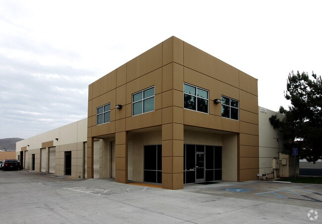


Property Detail
12390 Doherty St
172-381-006
LOT 10 MB 109/095 TR 11118
Lightindustrial
Riverside
M1
California
C and X Area of minimal flood hazard, usually depicted on FIRMs as above the 500-year flood level.
10
2024
0.51 AC
2025
Corona/Eastvale
041412
Inland Empire (California)
8,573 SF
Riverside-San Bernardino-Ontario, CA
NEARBY LISTINGS FOR SALE OR LEASE
DEMOGRAPHICS near 12390 Doherty St
1 mile
3 mile
5 mile
2025 Total Population
15,967
100,578
261,083
2030 Population
16,310
102,365
265,890
Pop Growth 2025-2030
+ 2.15%
+ 1.78%
+ 1.84%
Average Age
39
37
37
2025 Total Households
5,018
29,469
73,164
HH Growth 2025-2030
+ 1.71%
+ 1.30%
+ 1.36%
Median Household Inc
$89,589
$97,306
$96,280
Avg Household Size
3.10
3.30
3.30
2025 Avg HH Vehicles
2.00
2.00
2.00
Median Home Value
$624,213
$679,959
$687,183
Median Year Built
1986
1986
1981
Nearby Places
Map Layers
Map Styles
 Street
 Aerial
Layers
 Traffic
 Biking
Places
Listings with unknown addresses are not visible on the map
- Restaurants
- Banks
- Shops
- Fitness
- Groceries
PUBLIC TRANSPORTATION
COMMUTER RAIL
Riverside-La Sierra (91 Line - Southern California Regional Rail Authority (Metrolink), Inland Empire-Orange County Line - Southern California Regional Rail Authority (Metrolink))
Drive
Walk
Distance
Riverside-La Sierra (91 Line - Southern California Regional Rail Authority (Metrolink), Inland Empire-Orange County Line - Southern California Regional Rail Authority (Metrolink))
6 min
2.4 mi
North Main Corona (91 Line - Southern California Regional Rail Authority (Metrolink), Inland Empire-Orange County Line - Southern California Regional Rail Authority (Metrolink))
Drive
Walk
Distance
North Main Corona (91 Line - Southern California Regional Rail Authority (Metrolink), Inland Empire-Orange County Line - Southern California Regional Rail Authority (Metrolink))
9 min
5.2 mi
AIRPORT
Ontario International
Drive
Walk
Distance
Ontario International
26 min
17.8 mi
John Wayne/Orange County
Drive
Walk
Distance
John Wayne/Orange County
41 min
32.9 mi
Freight Ports
Port of Long Beach
Drive
Walk
Distance
Port of Long Beach
64 min
47.0 mi
SALE & LEASE HISTORY
LISTING DATE
SALE/LEASE

Mar 26, 2019
For Lease
Nearby Properties
Address
Land Use
TOTAL SIZE
Lot Size
Zoning
Address
Land Use
TOTAL SIZE
Lot Size
Zoning
1,662,289 SF
37.05 AC
Address
Land Use
TOTAL SIZE
Lot Size
Zoning
263,807 SF
13.14 AC
Address
Land Use
TOTAL SIZE
Lot Size
Zoning
167,068 SF
26.55 AC
Address
Land Use
TOTAL SIZE
Lot Size
Zoning
32,924 SF
24.04 AC
Address
Land Use
TOTAL SIZE
Lot Size
Zoning
76,546 SF
13.53 AC
R
Address
Land Use
TOTAL SIZE
Lot Size
Zoning
335,820 SF
15.18 AC
Address
Land Use
TOTAL SIZE
Lot Size
Zoning
205,235 SF
10.30 AC
Address
Land Use
TOTAL SIZE
Lot Size
Zoning
71,440 SF
14.37 AC
Address
Land Use
TOTAL SIZE
Lot Size
Zoning
289,297 SF
13.28 AC
M3
Address
Land Use
TOTAL SIZE
Lot Size
Zoning
186,190 SF
9.79 AC
Address
Land Use
TOTAL SIZE
Lot Size
Zoning
152,369 SF
5.38 AC
Address
Land Use
TOTAL SIZE
Lot Size
Zoning
150,404 SF
8.02 AC
Address
Land Use
TOTAL SIZE
Lot Size
Zoning
20.08 AC
R020
Address
Land Use
TOTAL SIZE
Lot Size
Zoning
27,916 SF
8.50 AC
R3
Address
Land Use
TOTAL SIZE
Lot Size
Zoning
115,545 SF
5.97 AC
Address
Land Use
TOTAL SIZE
Lot Size
Zoning
46,694 SF
7.16 AC
Address
Land Use
TOTAL SIZE
Lot Size
Zoning
171,707 SF
8.55 AC
Address
Land Use
TOTAL SIZE
Lot Size
Zoning
14 AC
R1
Address
Land Use
TOTAL SIZE
Lot Size
Zoning
149,389 SF
6.72 AC
Address
Land Use
TOTAL SIZE
Lot Size
Zoning
359,304 SF
8.86 AC
R3
Address
Land Use
TOTAL SIZE
Lot Size
Zoning
152,756 SF
7.07 AC
Address
Land Use
TOTAL SIZE
Lot Size
Zoning
52,928 SF
9.69 AC
Address
Land Use
TOTAL SIZE
Lot Size
Zoning
25,808 SF
6.21 AC
Address
Land Use
TOTAL SIZE
Lot Size
Zoning
4,562 SF
6.42 AC
Address
Land Use
TOTAL SIZE
Lot Size
Zoning
129,911 SF
6.10 AC
Address
Land Use
TOTAL SIZE
Lot Size
Zoning
116,787 SF
2.37 AC
Address
Land Use
TOTAL SIZE
Lot Size
Zoning
70,586 SF
4.45 AC
Address
Land Use
TOTAL SIZE
Lot Size
Zoning
156,599 SF
6.27 AC
The World's #1 Commercial Real Estate Marketplace
Connect with us
© 2026 CoStar Group
The information above has been obtained from sources believed reliable. While we do not doubt its accuracy we have not verified it and make no guarantee, warranty or representation about it. It is your responsibility to independently confirm its accuracy and completeness. Any projections, opinions, assumptions, or estimates used are for example only and do not represent the current or future performance of the property. The value of this transaction to you depends on tax and other factors which should be evaluated by your tax, financial, and legal advisors. You and your advisors should conduct a careful, independent investigation of the property to determine to your satisfaction the suitability of the property for your needs.