Property Record
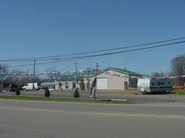
12390 Olean Rd, Sardinia, NY 14134

Property Detail
12390 Olean Rd
146200-311-000-0003-020-200
RESTRNT BURNED 9/95 227.61 FF N SCHUTT RD
Commercialnec
ERIE
05 - COMME
New York
A Areas with a 1% annual chance of flooding and a 26% chance of flooding over the life of a 30-year mortgage.
20.200
2025
1.75 AC
2024
Outlying Erie County
015102
Buffalo/Niagara Falls
1,728 SF
Buffalo-Cheektowaga, NY
NEARBY LISTINGS FOR SALE OR LEASE
DEMOGRAPHICS near 12390 Olean Rd
1 mile
3 mile
5 mile
2025 Total Population
381
4,542
8,586
2030 Population
380
4,493
8,491
Pop Growth 2025-2030
(0.26%)
(1.08%)
(1.11%)
Average Age
45
43
43
2025 Total Households
172
1,994
3,703
HH Growth 2025-2030
(0.58%)
(1.20%)
(1.22%)
Median Household Inc
$45,893
$55,282
$57,225
Avg Household Size
2.20
2.20
2.30
2025 Avg HH Vehicles
2.00
2.00
2.00
Median Home Value
$131,034
$141,388
$160,685
Median Year Built
1973
1976
1975
Nearby Places
Map Layers
Map Styles
 Street
 Aerial
Transit
 Traffic
 Biking
Places
Listings with unknown addresses are not visible on the map
- Restaurants
- Banks
- Shops
- Fitness
- Groceries
PUBLIC TRANSPORTATION
AIRPORT
Buffalo Niagara International
Drive
Walk
Distance
Buffalo Niagara International
55 min
35.0 mi
SALE & LEASE HISTORY
LISTING DATE
SALE/LEASE

Mar 20, 2018
For Sale
Jan 06, 2020
For Sale
Nearby Properties
Address
Land Use
TOTAL SIZE
Lot Size
Zoning
Address
Land Use
TOTAL SIZE
Lot Size
Zoning
5,250 SF
3 AC
L1
Address
Land Use
TOTAL SIZE
Lot Size
Zoning
69.27 AC
AR
Address
Land Use
TOTAL SIZE
Lot Size
Zoning
90,600 SF
18.91 AC
Address
Land Use
TOTAL SIZE
Lot Size
Zoning
95,987 SF
12.45 AC
HC
Address
Land Use
TOTAL SIZE
Lot Size
Zoning
49.59 AC
Address
Land Use
TOTAL SIZE
Lot Size
Zoning
46,173 SF
16.01 AC
Address
Land Use
TOTAL SIZE
Lot Size
Zoning
63,556 SF
11.92 AC
23
Address
Land Use
TOTAL SIZE
Lot Size
Zoning
Address
Land Use
TOTAL SIZE
Lot Size
Zoning
340,000 SF
22.16 AC
NC
Address
Land Use
TOTAL SIZE
Lot Size
Zoning
31,800 SF
4.32 AC
01 - NOT Z
Address
Land Use
TOTAL SIZE
Lot Size
Zoning
7,488 SF
9.83 AC
Address
Land Use
TOTAL SIZE
Lot Size
Zoning
6,889 SF
1.16 AC
HC
Address
Land Use
TOTAL SIZE
Lot Size
Zoning
80,490 SF
8.09 AC
AG
Address
Land Use
TOTAL SIZE
Lot Size
Zoning
3.70 AC
Address
Land Use
TOTAL SIZE
Lot Size
Zoning
9,680 SF
8.69 AC
Address
Land Use
TOTAL SIZE
Lot Size
Zoning
22,815 SF
34.80 AC
Address
Land Use
TOTAL SIZE
Lot Size
Zoning
3,420 SF
2.57 AC
R3
Address
Land Use
TOTAL SIZE
Lot Size
Zoning
3,648 SF
2.20 AC
CR
Address
Land Use
TOTAL SIZE
Lot Size
Zoning
11,500 SF
13.48 AC
07 - MIXED
Address
Land Use
TOTAL SIZE
Lot Size
Zoning
17,238 SF
6.10 AC
R2
Address
Land Use
TOTAL SIZE
Lot Size
Zoning
3,704 SF
1.14 AC
L1
Address
Land Use
TOTAL SIZE
Lot Size
Zoning
1,750 SF
0.76 AC
HC
Address
Land Use
TOTAL SIZE
Lot Size
Zoning
28,000 SF
1.77 AC
01 - NOT Z
Address
Land Use
TOTAL SIZE
Lot Size
Zoning
1,848 SF
10.12 AC
01 - NOT Z
Address
Land Use
TOTAL SIZE
Lot Size
Zoning
0.01 AC
Address
Land Use
TOTAL SIZE
Lot Size
Zoning
Address
Land Use
TOTAL SIZE
Lot Size
Zoning
Address
Land Use
TOTAL SIZE
Lot Size
Zoning
6,500 SF
0.94 AC
Address
Land Use
TOTAL SIZE
Lot Size
Zoning
10,680 SF
6.20 AC
01 - NOT Z
Address
Land Use
TOTAL SIZE
Lot Size
Zoning
30.70 AC
The World's #1 Commercial Real Estate Marketplace
Connect with us
© 2026 CoStar Group
The information above has been obtained from sources believed reliable. While we do not doubt its accuracy we have not verified it and make no guarantee, warranty or representation about it. It is your responsibility to independently confirm its accuracy and completeness. Any projections, opinions, assumptions, or estimates used are for example only and do not represent the current or future performance of the property. The value of this transaction to you depends on tax and other factors which should be evaluated by your tax, financial, and legal advisors. You and your advisors should conduct a careful, independent investigation of the property to determine to your satisfaction the suitability of the property for your needs.