Property Record
124 Chicken Farm Rd, Vinton, TX 79821


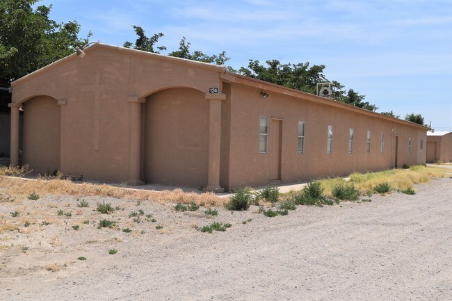
Property Detail
124 Chicken Farm Rd
El Paso, TX
1 RAMIREZ ADDITION LOT 3 (29790.00 SQ FT)
R141-000-0010-0300
El Paso
Commercialnec
Texas
2024
3
2025
0.68 AC
010231
Outlying El Paso County
4,226 SF
El Paso
NEARBY LISTINGS FOR SALE OR LEASE
DEMOGRAPHICS near 124 Chicken Farm Rd
1 mile
3 mile
5 mile
2024 Total Population
1,902
19,102
54,210
2029 Population
1,884
19,300
55,119
Pop Growth 2024-2029
(0.95%)
+ 1.04%
+ 1.68%
Average Age
37
36
35
2024 Total Households
611
5,781
17,313
HH Growth 2024-2029
(0.98%)
+ 1.02%
+ 1.65%
Median Household Inc
$46,288
$50,074
$62,261
Avg Household Size
3.00
3.10
3.00
2024 Avg HH Vehicles
2.00
2.00
2.00
Median Home Value
$144,871
$178,109
$192,025
Median Year Built
1990
1994
2000
Nearby Places
Map Layers
Map Styles
 Street
 Aerial
Transit
 Traffic
 Biking
Places
Listings with unknown addresses are not visible on the map
- Restaurants
- Banks
- Shops
- Fitness
- Groceries
PUBLIC TRANSPORTATION
AIRPORT
El Paso International
Drive
Walk
Distance
El Paso International
43 min
25.9 mi
Nearby Properties
Address
Land Use
TOTAL SIZE
Lot Size
Zoning
Address
Land Use
TOTAL SIZE
Lot Size
Zoning
409,742 SF
37.76 AC
C4
Address
Land Use
TOTAL SIZE
Lot Size
Zoning
402,206 SF
21.82 AC
C4C
Address
Land Use
TOTAL SIZE
Lot Size
Zoning
241,312 SF
108.16 AC
Address
Land Use
TOTAL SIZE
Lot Size
Zoning
79,722 SF
11 AC
C3
Address
Land Use
TOTAL SIZE
Lot Size
Zoning
206,600 SF
10.74 AC
AO
Address
Land Use
TOTAL SIZE
Lot Size
Zoning
415,500 SF
33.44 AC
M1
Address
Land Use
TOTAL SIZE
Lot Size
Zoning
104,721 SF
12.82 AC
C4C
Address
Land Use
TOTAL SIZE
Lot Size
Zoning
1 SF
2.39 AC
M1
Address
Land Use
TOTAL SIZE
Lot Size
Zoning
55,230 SF
13.11 AC
C4
Address
Land Use
TOTAL SIZE
Lot Size
Zoning
102,192 SF
5.11 AC
C3C
Address
Land Use
TOTAL SIZE
Lot Size
Zoning
31,785 SF
6.37 AC
M1S
Address
Land Use
TOTAL SIZE
Lot Size
Zoning
128,261 SF
52.29 AC
M2
Address
Land Use
TOTAL SIZE
Lot Size
Zoning
32,950 SF
35.70 AC
Address
Land Use
TOTAL SIZE
Lot Size
Zoning
29.28 AC
C4
Address
Land Use
TOTAL SIZE
Lot Size
Zoning
8,208 SF
2.34 AC
C4
Address
Land Use
TOTAL SIZE
Lot Size
Zoning
142,786 SF
54.77 AC
Address
Land Use
TOTAL SIZE
Lot Size
Zoning
26.38 AC
Address
Land Use
TOTAL SIZE
Lot Size
Zoning
25.54 AC
C4C
Address
Land Use
TOTAL SIZE
Lot Size
Zoning
17,780 SF
7.45 AC
C1
Address
Land Use
TOTAL SIZE
Lot Size
Zoning
22,590 SF
2.44 AC
C4C
Address
Land Use
TOTAL SIZE
Lot Size
Zoning
25,681 SF
3.19 AC
C4
Address
Land Use
TOTAL SIZE
Lot Size
Zoning
58,250 SF
5.13 AC
C4
Address
Land Use
TOTAL SIZE
Lot Size
Zoning
24,118 SF
1.39 AC
Address
Land Use
TOTAL SIZE
Lot Size
Zoning
37.97 AC
C4
Address
Land Use
TOTAL SIZE
Lot Size
Zoning
38,488 SF
37.19 AC
C1
Address
Land Use
TOTAL SIZE
Lot Size
Zoning
118,655 SF
14.53 AC
Address
Land Use
TOTAL SIZE
Lot Size
Zoning
6,483 SF
1.85 AC
C4
Address
Land Use
TOTAL SIZE
Lot Size
Zoning
1 SF
Address
Land Use
TOTAL SIZE
Lot Size
Zoning
42,000 SF
4.64 AC
C4C
Address
Land Use
TOTAL SIZE
Lot Size
Zoning
18,020 SF
10 AC
The World's #1 Commercial Real Estate Marketplace
Connect with us
© 2026 CoStar Group
The information above has been obtained from sources believed reliable. While we do not doubt its accuracy we have not verified it and make no guarantee, warranty or representation about it. It is your responsibility to independently confirm its accuracy and completeness. Any projections, opinions, assumptions, or estimates used are for example only and do not represent the current or future performance of the property. The value of this transaction to you depends on tax and other factors which should be evaluated by your tax, financial, and legal advisors. You and your advisors should conduct a careful, independent investigation of the property to determine to your satisfaction the suitability of the property for your needs.