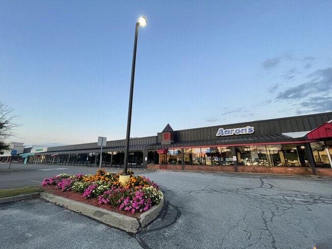
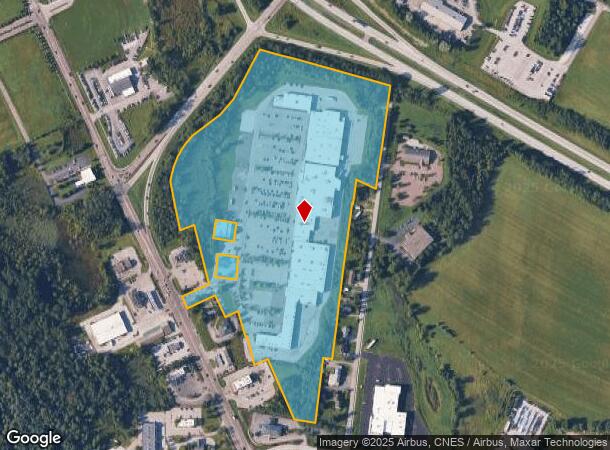
Property Record
124 Highgate Commons Rd, Saint Albans, VT 05478


NEARBY LISTINGS FOR SALE OR LEASE
Property Detail
124 Highgate Commons Rd
Burlington-South Burlington, VT
33.12A-COMM BLDG(SHOPPING CTR)
552-174-10631
Franklin
Retailwithmorethanonenonretailuse
Vermont
2021
33.12 AC
2024
Vermont North Area
010600
Other Market Areas
DEMOGRAPHICS near 124 Highgate Commons Rd
1 mile
3 mile
5 mile
2024 Total Population
546
11,736
16,993
2029 Population
568
12,273
17,754
Pop Growth 2024-2029
+ 4.03%
+ 4.58%
+ 4.48%
Average Age
42
40
41
2024 Total Households
218
4,995
7,096
HH Growth 2024-2029
+ 4.13%
+ 4.52%
+ 4.41%
Median Household Inc
$64,250
$63,589
$70,320
Avg Household Size
2.40
2.20
2.30
2024 Avg HH Vehicles
2.00
2.00
2.00
Median Home Value
$320,714
$251,317
$270,445
Median Year Built
1998
1967
1977
Nearby Places
Map Layers
Map Styles
 Street
 Aerial
Transit
 Traffic
 Biking
Places
Listings with unknown addresses are not visible on the map
- Restaurants
- Banks
- Shops
- Fitness
- Groceries
PUBLIC TRANSPORTATION
COMMUTER RAIL
St. Albans Amtrak Station (Vermonter - Amtrak)
Drive
Walk
Distance
St. Albans Amtrak Station (Vermonter - Amtrak)
5 min
2.3 mi
AIRPORT
Patrick Leahy Burlington International
Drive
Walk
Distance
Patrick Leahy Burlington International
46 min
30.7 mi
Freight Ports
Montreal
Drive
Walk
Distance
Montreal
92 min
68.7 mi
SALE & LEASE HISTORY
LISTING DATE
SALE/LEASE

Sep 25, 2016
For Lease
Dec 04, 2017
For Lease
Nearby Properties
Address
Land Use
TOTAL SIZE
Lot Size
Zoning
Address
Land Use
TOTAL SIZE
Lot Size
Zoning
10.45 AC
Address
Land Use
TOTAL SIZE
Lot Size
Zoning
3.50 AC
Address
Land Use
TOTAL SIZE
Lot Size
Zoning
8.73 AC
Address
Land Use
TOTAL SIZE
Lot Size
Zoning
Address
Land Use
TOTAL SIZE
Lot Size
Zoning
8.03 AC
Address
Land Use
TOTAL SIZE
Lot Size
Zoning
Address
Land Use
TOTAL SIZE
Lot Size
Zoning
Address
Land Use
TOTAL SIZE
Lot Size
Zoning
3.53 AC
Address
Land Use
TOTAL SIZE
Lot Size
Zoning
154,801 SF
52.16 AC
Address
Land Use
TOTAL SIZE
Lot Size
Zoning
3.93 AC
Address
Land Use
TOTAL SIZE
Lot Size
Zoning
45,136 SF
0.29 AC
Address
Land Use
TOTAL SIZE
Lot Size
Zoning
1.87 AC
Address
Land Use
TOTAL SIZE
Lot Size
Zoning
51,309 SF
0.37 AC
Address
Land Use
TOTAL SIZE
Lot Size
Zoning
Address
Land Use
TOTAL SIZE
Lot Size
Zoning
41,256 SF
4.76 AC
Address
Land Use
TOTAL SIZE
Lot Size
Zoning
41,256 SF
4.76 AC
Address
Land Use
TOTAL SIZE
Lot Size
Zoning
Address
Land Use
TOTAL SIZE
Lot Size
Zoning
0.66 AC
Address
Land Use
TOTAL SIZE
Lot Size
Zoning
Address
Land Use
TOTAL SIZE
Lot Size
Zoning
Address
Land Use
TOTAL SIZE
Lot Size
Zoning
Address
Land Use
TOTAL SIZE
Lot Size
Zoning
9.79 AC
Address
Land Use
TOTAL SIZE
Lot Size
Zoning
Address
Land Use
TOTAL SIZE
Lot Size
Zoning
14.07 AC
Address
Land Use
TOTAL SIZE
Lot Size
Zoning
22,065 SF
17.62 AC
Address
Land Use
TOTAL SIZE
Lot Size
Zoning
64.64 AC
Address
Land Use
TOTAL SIZE
Lot Size
Zoning
64.64 AC
Address
Land Use
TOTAL SIZE
Lot Size
Zoning
0.68 AC
Address
Land Use
TOTAL SIZE
Lot Size
Zoning
The World's #1 Commercial Real Estate Marketplace
Connect with us
© 2026 CoStar Group
The information above has been obtained from sources believed reliable. While we do not doubt its accuracy we have not verified it and make no guarantee, warranty or representation about it. It is your responsibility to independently confirm its accuracy and completeness. Any projections, opinions, assumptions, or estimates used are for example only and do not represent the current or future performance of the property. The value of this transaction to you depends on tax and other factors which should be evaluated by your tax, financial, and legal advisors. You and your advisors should conduct a careful, independent investigation of the property to determine to your satisfaction the suitability of the property for your needs.