Property Record
115 Avant St, Sarasota, FL 34232

Save to a Folder
{{folder.Name}}
{{folder.ListingIds.length}} Properties
{{folder.ListingIds.length}} Property
Create a New Folder
Property Detail
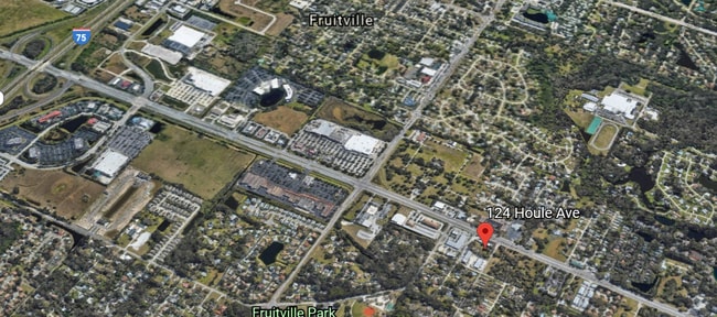
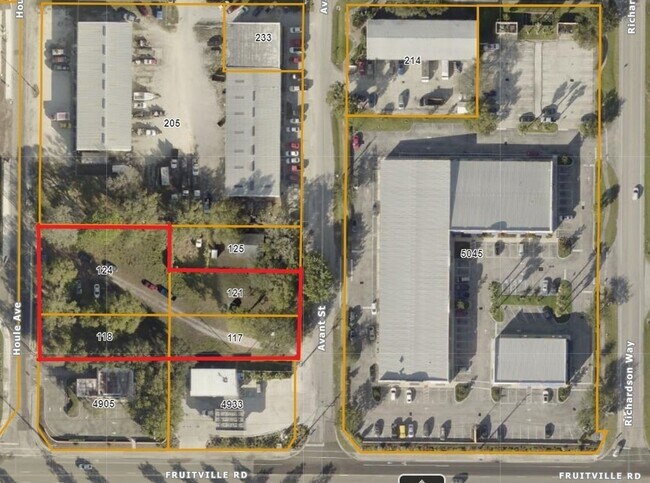
115 Avant St
North Port-Bradenton-Sarasota, FL
LOTS 9, 10, 11, 12 & 13, BLK A, GREERS ADDITION, BEING SAME LANDS AS DESC IN ORI 2021100267
0044-15-0029
SARASOTA
Commercialacreage
Florida
CG
10
B and X Area of moderate flood hazard, usually the area between the limits of the 100-year and 500-year floods.
0.85 AC
2024
Sarasota
2025
Tampa/St Petersburg
001301
NEARBY LISTINGS FOR SALE OR LEASE
DEMOGRAPHICS near 115 Avant St
1 mile
3 mile
5 mile
2025 Total Population
7,187
68,887
177,616
2030 Population
7,575
72,846
188,948
Pop Growth 2025-2030
+ 5.40%
+ 5.75%
+ 6.38%
Average Age
43
46
46
2025 Total Households
3,137
30,272
79,389
HH Growth 2025-2030
+ 4.94%
+ 5.79%
+ 6.49%
Median Household Inc
$73,942
$74,766
$77,990
Avg Household Size
2.20
2.20
2.10
2025 Avg HH Vehicles
2.00
2.00
2.00
Median Home Value
$406,325
$383,248
$443,651
Median Year Built
1986
1982
1985
Nearby Places
Map Layers
Map Styles
 Street
 Aerial
Layers
 Traffic
 Biking
Places
Listings with unknown addresses are not visible on the map
- Restaurants
- Banks
- Shops
- Fitness
- Groceries
PUBLIC TRANSPORTATION
AIRPORT
Sarasota/Bradenton International
Drive
Walk
Distance
Sarasota/Bradenton International
19 min
9.0 mi
Freight Ports
Port Manatee
Drive
Walk
Distance
Port Manatee
36 min
26.2 mi
SALE & LEASE HISTORY
LISTING DATE
SALE/LEASE

May 13, 2020
For Sale
Nearby Properties
Address
Land Use
TOTAL SIZE
Lot Size
Zoning
Address
Land Use
TOTAL SIZE
Lot Size
Zoning
92,398 SF
178.58 AC
OUE1
Address
Land Use
TOTAL SIZE
Lot Size
Zoning
409,467 SF
36.72 AC
RMF2
Address
Land Use
TOTAL SIZE
Lot Size
Zoning
359,089 SF
16.72 AC
PCD
Address
Land Use
TOTAL SIZE
Lot Size
Zoning
370,367 SF
27.32 AC
OPI
Address
Land Use
TOTAL SIZE
Lot Size
Zoning
332,686 SF
37.78 AC
VPD
Address
Land Use
TOTAL SIZE
Lot Size
Zoning
318,350 SF
14.30 AC
ILW
Address
Land Use
TOTAL SIZE
Lot Size
Zoning
415,689 SF
37.52 AC
OPI
Address
Land Use
TOTAL SIZE
Lot Size
Zoning
350,210 SF
13.36 AC
PED
Address
Land Use
TOTAL SIZE
Lot Size
Zoning
334,284 SF
30.55 AC
RMF3
Address
Land Use
TOTAL SIZE
Lot Size
Zoning
349,363 SF
22.58 AC
VPD
Address
Land Use
TOTAL SIZE
Lot Size
Zoning
352,070 SF
8.87 AC
ILW
Address
Land Use
TOTAL SIZE
Lot Size
Zoning
326,645 SF
17.96 AC
RMF3
Address
Land Use
TOTAL SIZE
Lot Size
Zoning
313,441 SF
26.91 AC
RSF2
Address
Land Use
TOTAL SIZE
Lot Size
Zoning
216,684 SF
30.52 AC
RMF2
Address
Land Use
TOTAL SIZE
Lot Size
Zoning
374,477 SF
15.55 AC
PED
Address
Land Use
TOTAL SIZE
Lot Size
Zoning
258,407 SF
18.55 AC
RMF3
Address
Land Use
TOTAL SIZE
Lot Size
Zoning
209,091 SF
21.30 AC
RMF3
Address
Land Use
TOTAL SIZE
Lot Size
Zoning
206,788 SF
122.30 AC
GU
Address
Land Use
TOTAL SIZE
Lot Size
Zoning
195,342 SF
20.20 AC
CSC
Address
Land Use
TOTAL SIZE
Lot Size
Zoning
170,631 SF
23.70 AC
RMF2
Address
Land Use
TOTAL SIZE
Lot Size
Zoning
157,351 SF
10.98 AC
ILW
Address
Land Use
TOTAL SIZE
Lot Size
Zoning
109,470 SF
17.23 AC
RSF2
Address
Land Use
TOTAL SIZE
Lot Size
Zoning
118,713 SF
31.70 AC
MCI
Address
Land Use
TOTAL SIZE
Lot Size
Zoning
11,248 SF
541.47 AC
GU
Address
Land Use
TOTAL SIZE
Lot Size
Zoning
139,916 SF
10.05 AC
PCD
Address
Land Use
TOTAL SIZE
Lot Size
Zoning
86,651 SF
22.68 AC
PED
Address
Land Use
TOTAL SIZE
Lot Size
Zoning
205,136 SF
17.32 AC
RMF2
Address
Land Use
TOTAL SIZE
Lot Size
Zoning
6,232 SF
37.84 AC
RMH
Address
Land Use
TOTAL SIZE
Lot Size
Zoning
136,248 SF
12.40 AC
RMF3
Address
Land Use
TOTAL SIZE
Lot Size
Zoning
64,454 SF
2.56 AC
PED
The World's #1 Commercial Real Estate Marketplace
Connect with us
© 2026 CoStar Group
The information above has been obtained from sources believed reliable. While we do not doubt its accuracy we have not verified it and make no guarantee, warranty or representation about it. It is your responsibility to independently confirm its accuracy and completeness. Any projections, opinions, assumptions, or estimates used are for example only and do not represent the current or future performance of the property. The value of this transaction to you depends on tax and other factors which should be evaluated by your tax, financial, and legal advisors. You and your advisors should conduct a careful, independent investigation of the property to determine to your satisfaction the suitability of the property for your needs.