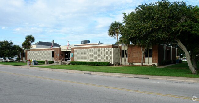
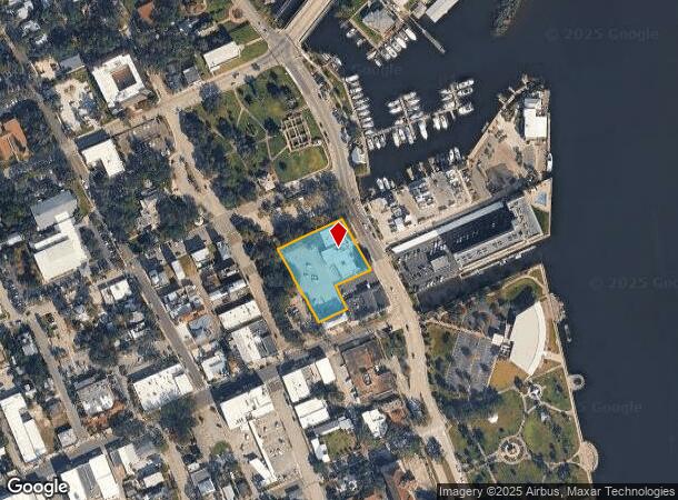
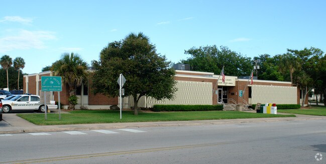
Property Record
124 N Riverside Dr, New Smyrna Beach, FL 32168
NEARBY LISTINGS FOR SALE OR LEASE
Property Detail
124 N Riverside Dr
7441-33-12-0050
Sams Estate New Smyrna Mb
Countyproperty
41-17-34 N 186 FT & N 77.5 FT OF S 127.50 FT OF W 98 FT OF BLK L SAMS ESTATE NEW SMYRNA MB 7 PG 44 MB 22 PG 114 PER OR 341 PG 729 OR 342 PG 1
AE
Volusia
12127C0543J
Florida
2025
1.10 AC
2025
South Beach Cities
082802
Deltona/Daytona Beach
9,734 SF
Deltona-Daytona Beach-Ormond Beach, FL
DEMOGRAPHICS near 124 N Riverside Dr
1 Mile
3 Mile
5 Mile
2024 Total Population
6,012
29,134
56,263
2029 Population
6,760
33,028
63,747
Pop Growth 2024-2029
+ 12.44%
+ 13.37%
+ 13.30%
Average Age
51
51
50
2024 Total Households
2,886
13,875
26,455
HH Growth 2024-2029
+ 12.75%
+ 13.79%
+ 13.70%
Median Household Inc
$51,278
$59,323
$61,174
Avg Household Size
1.90
2.00
2.00
2024 Avg HH Vehicles
2.00
2.00
2.00
Median Home Value
$287,084
$315,522
$285,122
Median Year Built
1974
1982
1985
Nearby Places
Map Layers
Map Styles
 Street
 Aerial
- Restaurants
- Banks
- Shops
- Fitness
- Groceries
PUBLIC TRANSPORTATION
AIRPORT
Daytona Beach International
DRIVE
WALK
Distance
Daytona Beach International
28 min
19.0 mi
Orlando Sanford International
DRIVE
WALK
Distance
Orlando Sanford International
48 min
32.8 mi
Freight Ports
Port Canaveral
DRIVE
WALK
Distance
Port Canaveral
75 min
61.5 mi
Nearby Properties
Address
Land Use
TOTAL SIZE
Lot Size
Zoning
Address
Land Use
TOTAL SIZE
Lot Size
Zoning
360,394 SF
65.63 AC
01R4
Address
Land Use
TOTAL SIZE
Lot Size
Zoning
177,619 SF
6.91 AC
10R2
Address
Land Use
TOTAL SIZE
Lot Size
Zoning
108,577 SF
20 AC
10R2
Address
Land Use
TOTAL SIZE
Lot Size
Zoning
209,027 SF
29.13 AC
10R2A
Address
Land Use
TOTAL SIZE
Lot Size
Zoning
68,493 SF
1.89 AC
10B6
Address
Land Use
TOTAL SIZE
Lot Size
Zoning
115,562 SF
1.40 AC
10B4
Address
Land Use
TOTAL SIZE
Lot Size
Zoning
70,564 SF
2.09 AC
10B1
Address
Land Use
TOTAL SIZE
Lot Size
Zoning
150,044 SF
19.80 AC
R4
Address
Land Use
TOTAL SIZE
Lot Size
Zoning
5,796 SF
71.96 AC
R
Address
Land Use
TOTAL SIZE
Lot Size
Zoning
134,246 SF
13.58 AC
10B5
Address
Land Use
TOTAL SIZE
Lot Size
Zoning
89,919 SF
1.49 AC
10B4
Address
Land Use
TOTAL SIZE
Lot Size
Zoning
0.20 AC
B46
Address
Land Use
TOTAL SIZE
Lot Size
Zoning
23,142 SF
7.98 AC
R
Address
Land Use
TOTAL SIZE
Lot Size
Zoning
91,509 SF
4.06 AC
I1
Address
Land Use
TOTAL SIZE
Lot Size
Zoning
7,345 SF
0.43 AC
MH1
Address
Land Use
TOTAL SIZE
Lot Size
Zoning
11.87 AC
10R2A
Address
Land Use
TOTAL SIZE
Lot Size
Zoning
91,759 SF
10.15 AC
10B2
Address
Land Use
TOTAL SIZE
Lot Size
Zoning
87,154 SF
1.08 AC
10R5
Address
Land Use
TOTAL SIZE
Lot Size
Zoning
51,507 SF
10.61 AC
B3C
Address
Land Use
TOTAL SIZE
Lot Size
Zoning
39,971 SF
281.52 AC
10I3
Address
Land Use
TOTAL SIZE
Lot Size
Zoning
43,852 SF
8.81 AC
RR
Address
Land Use
TOTAL SIZE
Lot Size
Zoning
18,884 SF
12.47 AC
R
Address
Land Use
TOTAL SIZE
Lot Size
Zoning
111,686 SF
10.03 AC
10B5
Address
Land Use
TOTAL SIZE
Lot Size
Zoning
74,609 SF
12.67 AC
10B3
Address
Land Use
TOTAL SIZE
Lot Size
Zoning
119,537 SF
12.06 AC
PUD
Address
Land Use
TOTAL SIZE
Lot Size
Zoning
55,587 SF
85.39 AC
R4
Address
Land Use
TOTAL SIZE
Lot Size
Zoning
229,941 SF
0.57 AC
10R2A
Address
Land Use
TOTAL SIZE
Lot Size
Zoning
115,028 SF
16.51 AC
R4
Address
Land Use
TOTAL SIZE
Lot Size
Zoning
44,239 SF
2.31 AC
10B1
Address
Land Use
TOTAL SIZE
Lot Size
Zoning
98,105 SF
8.03 AC
07B3
The World's #1 Commercial Real Estate Marketplace
Connect with us
© 2025 CoStar Group
The information above has been obtained from sources believed reliable. While we do not doubt its accuracy we have not verified it and make no guarantee, warranty or representation about it. It is your responsibility to independently confirm its accuracy and completeness. Any projections, opinions, assumptions, or estimates used are for example only and do not represent the current or future performance of the property. The value of this transaction to you depends on tax and other factors which should be evaluated by your tax, financial, and legal advisors. You and your advisors should conduct a careful, independent investigation of the property to determine to your satisfaction the suitability of the property for your needs.