Property Record
124 Sterling Rd, Sterling, CT 06377
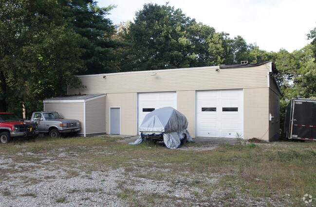


Property Detail
124 Sterling Rd
STER-003844-000016A-000006
Northeastern Ct
Industrialgeneral
Connecticut
B and X Area of moderate flood hazard, usually the area between the limits of the 100-year and 500-year floods.
6
2025
0.43 AC
2025
Windham County
908100
Hartford
1,600 SF
Willimantic, CT
NEARBY LISTINGS FOR SALE OR LEASE
DEMOGRAPHICS near 124 Sterling Rd
1 mile
3 mile
5 mile
2025 Total Population
643
8,452
19,246
2030 Population
662
8,690
19,660
Pop Growth 2025-2030
+ 2.95%
+ 2.82%
+ 2.15%
Average Age
42
41
42
2025 Total Households
246
3,321
7,514
HH Growth 2025-2030
+ 2.85%
+ 2.98%
+ 2.28%
Median Household Inc
$78,750
$86,496
$81,740
Avg Household Size
2.50
2.50
2.50
2025 Avg HH Vehicles
2.00
2.00
2.00
Median Home Value
$245,082
$298,743
$286,343
Median Year Built
1976
1970
1971
Nearby Places
Map Layers
Map Styles
 Street
 Aerial
Layers
 Traffic
 Biking
Places
Listings with unknown addresses are not visible on the map
- Restaurants
- Banks
- Shops
- Fitness
- Groceries
Nearby Properties
Address
Land Use
TOTAL SIZE
Lot Size
Zoning
Address
Land Use
TOTAL SIZE
Lot Size
Zoning
77,452 SF
40 AC
Address
Land Use
TOTAL SIZE
Lot Size
Zoning
55,128 SF
5 AC
RA19
Address
Land Use
TOTAL SIZE
Lot Size
Zoning
10.29 AC
RA19
Address
Land Use
TOTAL SIZE
Lot Size
Zoning
14.80 AC
Address
Land Use
TOTAL SIZE
Lot Size
Zoning
233,322 SF
13.60 AC
I
Address
Land Use
TOTAL SIZE
Lot Size
Zoning
5.18 AC
IND
Address
Land Use
TOTAL SIZE
Lot Size
Zoning
9,066 SF
1.20 AC
C2
Address
Land Use
TOTAL SIZE
Lot Size
Zoning
25.50 AC
Address
Land Use
TOTAL SIZE
Lot Size
Zoning
25,000 SF
5.60 AC
IND
Address
Land Use
TOTAL SIZE
Lot Size
Zoning
6.70 AC
RA19
Address
Land Use
TOTAL SIZE
Lot Size
Zoning
0.82 AC
C2
Address
Land Use
TOTAL SIZE
Lot Size
Zoning
18,224 SF
0.75 AC
RA19
Address
Land Use
TOTAL SIZE
Lot Size
Zoning
2.10 AC
C2
Address
Land Use
TOTAL SIZE
Lot Size
Zoning
90,915 SF
1.78 AC
IND-1
Address
Land Use
TOTAL SIZE
Lot Size
Zoning
18,238 SF
2.31 AC
RA60
Address
Land Use
TOTAL SIZE
Lot Size
Zoning
6.87 AC
RA60
Address
Land Use
TOTAL SIZE
Lot Size
Zoning
72.76 AC
Address
Land Use
TOTAL SIZE
Lot Size
Zoning
101.50 AC
R-80
Address
Land Use
TOTAL SIZE
Lot Size
Zoning
24,416 SF
3.99 AC
Address
Land Use
TOTAL SIZE
Lot Size
Zoning
1.75 AC
C
Address
Land Use
TOTAL SIZE
Lot Size
Zoning
7,765 SF
1.10 AC
RA60
Address
Land Use
TOTAL SIZE
Lot Size
Zoning
0.96 AC
C2
Address
Land Use
TOTAL SIZE
Lot Size
Zoning
3,200 SF
19.85 AC
Address
Land Use
TOTAL SIZE
Lot Size
Zoning
55.19 AC
Address
Land Use
TOTAL SIZE
Lot Size
Zoning
20,480 SF
7.20 AC
Address
Land Use
TOTAL SIZE
Lot Size
Zoning
4,956 SF
0.75 AC
RA19
Address
Land Use
TOTAL SIZE
Lot Size
Zoning
2,604 SF
0.79 AC
C2
Address
Land Use
TOTAL SIZE
Lot Size
Zoning
56.57 AC
Address
Land Use
TOTAL SIZE
Lot Size
Zoning
6,174 SF
1 AC
C2
Address
Land Use
TOTAL SIZE
Lot Size
Zoning
231.31 AC
RA60
The World's #1 Commercial Real Estate Marketplace
Connect with us
© 2026 CoStar Group
The information above has been obtained from sources believed reliable. While we do not doubt its accuracy we have not verified it and make no guarantee, warranty or representation about it. It is your responsibility to independently confirm its accuracy and completeness. Any projections, opinions, assumptions, or estimates used are for example only and do not represent the current or future performance of the property. The value of this transaction to you depends on tax and other factors which should be evaluated by your tax, financial, and legal advisors. You and your advisors should conduct a careful, independent investigation of the property to determine to your satisfaction the suitability of the property for your needs.