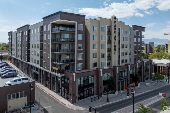
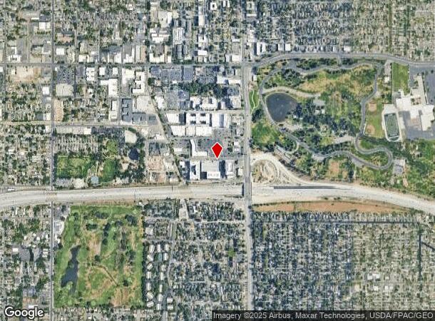
Property Record
1240 E Stringham Ave, Salt Lake City, UT 84106

NEARBY LISTINGS FOR SALE OR LEASE
Property Detail
1240 E Stringham Ave
Salt Lake City-Murray, UT
Sugarhouse Center
16-20-276-066-0000
LOT 4C, SUGARHOUSE CENTER AMD.
Apartment
Salt Lake
X
Utah
49035C0301H
4c
2024
1.62 AC
2025
Sugar House
114100
Salt Lake City
297,476 SF
DEMOGRAPHICS near 1240 E Stringham Ave
1 mile
3 mile
5 mile
2024 Total Population
19,944
155,555
333,171
2029 Population
20,221
157,332
337,742
Pop Growth 2024-2029
+ 1.39%
+ 1.14%
+ 1.37%
Average Age
38
37
38
2024 Total Households
9,176
66,733
140,191
HH Growth 2024-2029
+ 1.68%
+ 1.26%
+ 1.66%
Median Household Inc
$82,038
$71,223
$67,544
Avg Household Size
2.10
2.20
2.20
2024 Avg HH Vehicles
2.00
2.00
2.00
Median Home Value
$492,335
$541,316
$505,946
Median Year Built
1957
1963
1971
Nearby Places
Map Layers
Map Styles
 Street
 Aerial
Transit
 Traffic
 Biking
Places
Listings with unknown addresses are not visible on the map
- Restaurants
- Banks
- Shops
- Fitness
- Groceries
PUBLIC TRANSPORTATION
TRANSIT/SUBWAY
Fairmont Station (S-Line - Utah Transit Authority (UTA))
Drive
Walk
Distance
Fairmont Station (S-Line - Utah Transit Authority (UTA))
1 min
8 min
0.4 mi
Sugarmont Station (S-Line - Utah Transit Authority (UTA))
Drive
Walk
Distance
Sugarmont Station (S-Line - Utah Transit Authority (UTA))
1 min
11 min
0.6 mi
700 East Station (S-Line - Utah Transit Authority (UTA))
Drive
Walk
Distance
700 East Station (S-Line - Utah Transit Authority (UTA))
3 min
19 min
1.0 mi
COMMUTER RAIL
North Temple Station (FrontRunner - Utah Transit Authority (UTA))
Drive
Walk
Distance
North Temple Station (FrontRunner - Utah Transit Authority (UTA))
11 min
7.1 mi
Warm Springs Relief Point (FrontRunner - Utah Transit Authority (UTA))
Drive
Walk
Distance
Warm Springs Relief Point (FrontRunner - Utah Transit Authority (UTA))
12 min
8.5 mi
AIRPORT
Salt Lake City International
Drive
Walk
Distance
Salt Lake City International
15 min
11.1 mi
Freight Ports
Port of Stockton
Drive
Walk
Distance
Port of Stockton
715 min
701.5 mi
SALE & LEASE HISTORY
LISTING DATE
SALE/LEASE

Oct 19, 2020
For Lease
Nearby Properties
Address
Land Use
TOTAL SIZE
Lot Size
Zoning
Address
Land Use
TOTAL SIZE
Lot Size
Zoning
591,924 SF
80.77 AC
I
Address
Land Use
TOTAL SIZE
Lot Size
Zoning
1,262,865 SF
44.15 AC
I
Address
Land Use
TOTAL SIZE
Lot Size
Zoning
530,605 SF
127 AC
RP
Address
Land Use
TOTAL SIZE
Lot Size
Zoning
365,253 SF
33.64 AC
I
Address
Land Use
TOTAL SIZE
Lot Size
Zoning
298,628 SF
27.30 AC
I
Address
Land Use
TOTAL SIZE
Lot Size
Zoning
299,535 SF
38 AC
I
Address
Land Use
TOTAL SIZE
Lot Size
Zoning
254,939 SF
34.68 AC
I
Address
Land Use
TOTAL SIZE
Lot Size
Zoning
440,898 SF
0.01 AC
RP
Address
Land Use
TOTAL SIZE
Lot Size
Zoning
497,018 SF
13.11 AC
I
Address
Land Use
TOTAL SIZE
Lot Size
Zoning
814,747 SF
2.73 AC
CSHBD1
Address
Land Use
TOTAL SIZE
Lot Size
Zoning
163,932 SF
14.65 AC
PL
Address
Land Use
TOTAL SIZE
Lot Size
Zoning
95,666 SF
52.19 AC
I
Address
Land Use
TOTAL SIZE
Lot Size
Zoning
8,042 SF
64.58 AC
RP
Address
Land Use
TOTAL SIZE
Lot Size
Zoning
691,463 SF
17.80 AC
RM
Address
Land Use
TOTAL SIZE
Lot Size
Zoning
208,868 SF
20.41 AC
I
Address
Land Use
TOTAL SIZE
Lot Size
Zoning
183,600 SF
10.70 AC
RMF-35
Address
Land Use
TOTAL SIZE
Lot Size
Zoning
128,997 SF
3.04 AC
ESN
Address
Land Use
TOTAL SIZE
Lot Size
Zoning
152,660 SF
5.40 AC
I
Address
Land Use
TOTAL SIZE
Lot Size
Zoning
369,717 SF
2.50 AC
RO
Address
Land Use
TOTAL SIZE
Lot Size
Zoning
502,104 SF
4.11 AC
E ST C
Address
Land Use
TOTAL SIZE
Lot Size
Zoning
412,006 SF
1.70 AC
C3
Address
Land Use
TOTAL SIZE
Lot Size
Zoning
371,963 SF
1.81 AC
R-MU
Address
Land Use
TOTAL SIZE
Lot Size
Zoning
369,377 SF
1.65 AC
Address
Land Use
TOTAL SIZE
Lot Size
Zoning
321,882 SF
0.01 AC
CSHBD1
Address
Land Use
TOTAL SIZE
Lot Size
Zoning
152,579 SF
25.45 AC
I
Address
Land Use
TOTAL SIZE
Lot Size
Zoning
426,600 SF
1.61 AC
CSHBD1
Address
Land Use
TOTAL SIZE
Lot Size
Zoning
95,854 SF
15.42 AC
CC
Address
Land Use
TOTAL SIZE
Lot Size
Zoning
903,167 SF
1.90 AC
CSHBD1
Address
Land Use
TOTAL SIZE
Lot Size
Zoning
191,876 SF
3.18 AC
TSAUNC
The World's #1 Commercial Real Estate Marketplace
Connect with us
© 2026 CoStar Group
The information above has been obtained from sources believed reliable. While we do not doubt its accuracy we have not verified it and make no guarantee, warranty or representation about it. It is your responsibility to independently confirm its accuracy and completeness. Any projections, opinions, assumptions, or estimates used are for example only and do not represent the current or future performance of the property. The value of this transaction to you depends on tax and other factors which should be evaluated by your tax, financial, and legal advisors. You and your advisors should conduct a careful, independent investigation of the property to determine to your satisfaction the suitability of the property for your needs.