Property Record
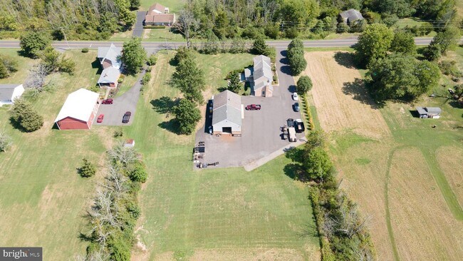
1240 Richlandtown Pike, Richlandtown, PA 18955

NEARBY LISTINGS FOR SALE OR LEASE
Property Detail
1240 Richlandtown Pike
Philadelphia-Camden-Wilmington, PA-NJ-DE-MD
Richlandtown
36-029-028
Bucks
Sfr
Pennsylvania
X
2.02 AC
42017C0130J
Bucks
2,878 SF
Philadelphia
DEMOGRAPHICS near 1240 Richlandtown Pike
1 Mile
3 Mile
5 Mile
2024 Total Population
1,602
11,175
40,169
2029 Population
1,595
11,043
40,130
Pop Growth 2024-2029
(0.44%)
(1.18%)
(0.10%)
Average Age
45
44
42
2024 Total Households
560
4,399
15,108
HH Growth 2024-2029
(0.54%)
(1.34%)
(0.24%)
Median Household Inc
$77,599
$78,999
$88,845
Avg Household Size
2.50
2.40
2.50
2024 Avg HH Vehicles
2.00
2.00
2.00
Median Home Value
$275,574
$270,707
$326,931
Median Year Built
1967
1975
1975
Nearby Places
Map Layers
Map Styles
 Street
 Aerial
- Restaurants
- Banks
- Shops
- Fitness
- Groceries
PUBLIC TRANSPORTATION
AIRPORT
Lehigh Valley International
DRIVE
WALK
Distance
Lehigh Valley International
35 min
18.8 mi
Freight Ports
Port of Philadelphia
DRIVE
WALK
Distance
Port of Philadelphia
69 min
41.8 mi
SALE & LEASE HISTORY
LISTING DATE
SALE/LEASE

Sep 17, 2022
For Sale
Nearby Properties
Address
Land Use
TOTAL SIZE
Lot Size
Zoning
Address
Land Use
TOTAL SIZE
Lot Size
Zoning
276,132 SF
61.72 AC
PC
Address
Land Use
TOTAL SIZE
Lot Size
Zoning
51,884 SF
40.42 AC
EXT
Address
Land Use
TOTAL SIZE
Lot Size
Zoning
145,197 SF
17.11 AC
PC
Address
Land Use
TOTAL SIZE
Lot Size
Zoning
362,576 SF
25.24 AC
PI
Address
Land Use
TOTAL SIZE
Lot Size
Zoning
145,800 SF
11.66 AC
P1
Address
Land Use
TOTAL SIZE
Lot Size
Zoning
7.98 AC
PI
Address
Land Use
TOTAL SIZE
Lot Size
Zoning
186,547 SF
18.74 AC
PI
Address
Land Use
TOTAL SIZE
Lot Size
Zoning
1,200 SF
17.50 AC
PI
Address
Land Use
TOTAL SIZE
Lot Size
Zoning
114,400 SF
9.96 AC
P1
Address
Land Use
TOTAL SIZE
Lot Size
Zoning
71,000 SF
5.90 AC
EXT
Address
Land Use
TOTAL SIZE
Lot Size
Zoning
34,206 SF
11.49 AC
PC
Address
Land Use
TOTAL SIZE
Lot Size
Zoning
170,655 SF
25.75 AC
PI
Address
Land Use
TOTAL SIZE
Lot Size
Zoning
16,114 SF
6.13 AC
PC
Address
Land Use
TOTAL SIZE
Lot Size
Zoning
107,925 SF
17.05 AC
RA
Address
Land Use
TOTAL SIZE
Lot Size
Zoning
43,840 SF
6 AC
PC
Address
Land Use
TOTAL SIZE
Lot Size
Zoning
50,055 SF
7.75 AC
EXT
Address
Land Use
TOTAL SIZE
Lot Size
Zoning
48,810 SF
10.07 AC
PC
Address
Land Use
TOTAL SIZE
Lot Size
Zoning
125,116 SF
9.55 AC
PI
Address
Land Use
TOTAL SIZE
Lot Size
Zoning
106,560 SF
12.02 AC
PI
Address
Land Use
TOTAL SIZE
Lot Size
Zoning
76,800 SF
5.32 AC
PI
Address
Land Use
TOTAL SIZE
Lot Size
Zoning
61,888 SF
5.01 AC
C2
Address
Land Use
TOTAL SIZE
Lot Size
Zoning
147,310 SF
7.44 AC
LI
Address
Land Use
TOTAL SIZE
Lot Size
Zoning
19,036 SF
16.40 AC
PC
Address
Land Use
TOTAL SIZE
Lot Size
Zoning
5,655 SF
1.79 AC
PC
Address
Land Use
TOTAL SIZE
Lot Size
Zoning
31,500 SF
7.22 AC
PI
Address
Land Use
TOTAL SIZE
Lot Size
Zoning
49,873 SF
4.07 AC
R3
Address
Land Use
TOTAL SIZE
Lot Size
Zoning
56,665 SF
5.35 AC
PI
Address
Land Use
TOTAL SIZE
Lot Size
Zoning
7,421 SF
0.90 AC
C2
Address
Land Use
TOTAL SIZE
Lot Size
Zoning
33,702 SF
6.14 AC
PC
Address
Land Use
TOTAL SIZE
Lot Size
Zoning
42,388 SF
19.68 AC
PI
The World's #1 Commercial Real Estate Marketplace
Connect with us
© 2026 CoStar Group
The information above has been obtained from sources believed reliable. While we do not doubt its accuracy we have not verified it and make no guarantee, warranty or representation about it. It is your responsibility to independently confirm its accuracy and completeness. Any projections, opinions, assumptions, or estimates used are for example only and do not represent the current or future performance of the property. The value of this transaction to you depends on tax and other factors which should be evaluated by your tax, financial, and legal advisors. You and your advisors should conduct a careful, independent investigation of the property to determine to your satisfaction the suitability of the property for your needs.