Property Record
12401 Morang Dr, Detroit, MI 48224
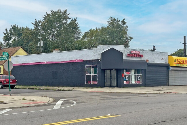

This Property Is For Sale
NEARBY LISTINGS FOR SALE OR LEASE
Property Detail
12401 Morang Dr
21-076821
Yorkshire Woods No 7
Storebuilding
W MORANG 1318&1317 YORKSHIRE WOODS SUB NO 7 L54 P88 PLATS, W C R 21/899 41 X 100
X
Wayne
26163C0140F
Michigan
2025
0.09 AC
2025
Detroit E of Woodward
500900
Detroit
2,854 SF
Detroit-Warren-Dearborn, MI
DEMOGRAPHICS near 12401 Morang Dr
1 Mile
3 Mile
5 Mile
2024 Total Population
25,974
173,291
341,842
2029 Population
26,202
173,236
340,375
Pop Growth 2024-2029
+ 0.88%
(0.03%)
(0.43%)
Average Age
34
37
39
2024 Total Households
8,855
63,595
132,034
HH Growth 2024-2029
+ 0.80%
(0.17%)
(0.53%)
Median Household Inc
$42,149
$43,962
$48,230
Avg Household Size
2.90
2.60
2.50
2024 Avg HH Vehicles
1.00
1.00
1.00
Median Home Value
$62,416
$91,540
$122,943
Median Year Built
1950
1951
1953
Nearby Places
Map Layers
Map Styles
 Street
 Aerial
- Restaurants
- Banks
- Shops
- Fitness
- Groceries
PUBLIC TRANSPORTATION
COMMUTER RAIL
DRIVE
WALK
Distance
16 min
9.5 mi
AIRPORT
Windsor International
DRIVE
WALK
Distance
Windsor International
42 min
20.9 mi
Detroit Metro Wayne County
DRIVE
WALK
Distance
Detroit Metro Wayne County
45 min
30.4 mi
Nearby Properties
Address
Land Use
TOTAL SIZE
Lot Size
Zoning
Address
Land Use
TOTAL SIZE
Lot Size
Zoning
1,034,990 SF
28.60 AC
Address
Land Use
TOTAL SIZE
Lot Size
Zoning
575,081 SF
8.53 AC
R6
Address
Land Use
TOTAL SIZE
Lot Size
Zoning
182,866 SF
5.08 AC
PD
Address
Land Use
TOTAL SIZE
Lot Size
Zoning
101,733 SF
1.10 AC
C-2
Address
Land Use
TOTAL SIZE
Lot Size
Zoning
358,327 SF
M4
Address
Land Use
TOTAL SIZE
Lot Size
Zoning
302,305 SF
M4
Address
Land Use
TOTAL SIZE
Lot Size
Zoning
156,352 SF
2.72 AC
B-3
Address
Land Use
TOTAL SIZE
Lot Size
Zoning
26,068 SF
5.57 AC
B-2
Address
Land Use
TOTAL SIZE
Lot Size
Zoning
115,839 SF
8.54 AC
M4
Address
Land Use
TOTAL SIZE
Lot Size
Zoning
30,919 SF
0.86 AC
C
Address
Land Use
TOTAL SIZE
Lot Size
Zoning
36,417 SF
0.68 AC
B4
Address
Land Use
TOTAL SIZE
Lot Size
Zoning
141,023 SF
7.96 AC
MZ
Address
Land Use
TOTAL SIZE
Lot Size
Zoning
130,276 SF
6.24 AC
M-2
Address
Land Use
TOTAL SIZE
Lot Size
Zoning
80,320 SF
4.73 AC
RM-1
Address
Land Use
TOTAL SIZE
Lot Size
Zoning
233,876 SF
8.20 AC
Address
Land Use
TOTAL SIZE
Lot Size
Zoning
36,191 SF
3.87 AC
B-2
Address
Land Use
TOTAL SIZE
Lot Size
Zoning
89,120 SF
10.75 AC
M-3
Address
Land Use
TOTAL SIZE
Lot Size
Zoning
87,897 SF
4.50 AC
RM-1
Address
Land Use
TOTAL SIZE
Lot Size
Zoning
49,807 SF
0.84 AC
PD
Address
Land Use
TOTAL SIZE
Lot Size
Zoning
10,908 SF
2.78 AC
B-3
Address
Land Use
TOTAL SIZE
Lot Size
Zoning
109,016 SF
7.96 AC
MZ
Address
Land Use
TOTAL SIZE
Lot Size
Zoning
92,610 SF
1.76 AC
B-3
Address
Land Use
TOTAL SIZE
Lot Size
Zoning
36,086 SF
2.05 AC
B2
Address
Land Use
TOTAL SIZE
Lot Size
Zoning
55,321 SF
4.01 AC
PD
Address
Land Use
TOTAL SIZE
Lot Size
Zoning
101,814 SF
3.74 AC
R-2
Address
Land Use
TOTAL SIZE
Lot Size
Zoning
60,484 SF
4.85 AC
PD
Address
Land Use
TOTAL SIZE
Lot Size
Zoning
28,444 SF
0.97 AC
B-3
Address
Land Use
TOTAL SIZE
Lot Size
Zoning
116,099 SF
5.73 AC
M-2
Address
Land Use
TOTAL SIZE
Lot Size
Zoning
38,577 SF
1.91 AC
C
Address
Land Use
TOTAL SIZE
Lot Size
Zoning
43,967 SF
2.80 AC
O-1
The World's #1 Commercial Real Estate Marketplace
Connect with us
© 2026 CoStar Group
The information above has been obtained from sources believed reliable. While we do not doubt its accuracy we have not verified it and make no guarantee, warranty or representation about it. It is your responsibility to independently confirm its accuracy and completeness. Any projections, opinions, assumptions, or estimates used are for example only and do not represent the current or future performance of the property. The value of this transaction to you depends on tax and other factors which should be evaluated by your tax, financial, and legal advisors. You and your advisors should conduct a careful, independent investigation of the property to determine to your satisfaction the suitability of the property for your needs.