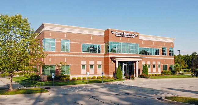
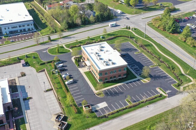
Property Record
12401 Plantside Dr, Louisville, KY 40299

NEARBY LISTINGS FOR SALE OR LEASE
Property Detail
12401 Plantside Dr
Louisville-Jefferson County, KY-IN
Blankenbaker Station Ii
003911000000
LOT 4 BLANKENBAKER STATION II, PHASE 1A, PB. 53, PG. 33, 2-4-2009, OFF BLK 339 LOT 69, 2 AC +/-
Officebuilding
Jefferson
X
Kentucky
21111C0065F
2,4,69
2025
2 AC
2025
Southeast
011116
Louisville
15,412 SF
DEMOGRAPHICS near 12401 Plantside Dr
1 Mile
3 Mile
5 Mile
2024 Total Population
2,120
48,040
121,483
2029 Population
2,116
47,374
119,838
Pop Growth 2024-2029
(0.19%)
(1.39%)
(1.35%)
Average Age
43
42
42
2024 Total Households
1,006
20,481
50,444
HH Growth 2024-2029
(0.40%)
(1.44%)
(1.41%)
Median Household Inc
$68,849
$84,928
$89,337
Avg Household Size
2.10
2.30
2.40
2024 Avg HH Vehicles
2.00
2.00
2.00
Median Home Value
$317,751
$291,538
$286,040
Median Year Built
2004
1989
1986
Nearby Places
Map Layers
Map Styles
 Street
 Aerial
- Restaurants
- Banks
- Shops
- Fitness
- Groceries
PUBLIC TRANSPORTATION
AIRPORT
Louisville Muhammad Ali International
DRIVE
WALK
Distance
Louisville Muhammad Ali International
30 min
18.0 mi
SALE & LEASE HISTORY
LISTING DATE
SALE/LEASE

Jan 09, 2018
For Lease
Jan 09, 2018
For Sale
Nearby Properties
Address
Land Use
TOTAL SIZE
Lot Size
Zoning
Address
Land Use
TOTAL SIZE
Lot Size
Zoning
115.43 AC
R4-RESIDEN
Address
Land Use
TOTAL SIZE
Lot Size
Zoning
2,776 SF
34.17 AC
R4-RESIDEN
Address
Land Use
TOTAL SIZE
Lot Size
Zoning
1,194 SF
38.74 AC
R4-RESIDEN
Address
Land Use
TOTAL SIZE
Lot Size
Zoning
8,200 SF
25.23 AC
Address
Land Use
TOTAL SIZE
Lot Size
Zoning
3,172 SF
17.51 AC
R1-RESIDEN
Address
Land Use
TOTAL SIZE
Lot Size
Zoning
1,334 SF
24.71 AC
R4-RESIDEN
Address
Land Use
TOTAL SIZE
Lot Size
Zoning
Address
Land Use
TOTAL SIZE
Lot Size
Zoning
8.47 AC
R1-RESIDEN
Address
Land Use
TOTAL SIZE
Lot Size
Zoning
31.03 AC
C1-COMMERC
Address
Land Use
TOTAL SIZE
Lot Size
Zoning
45.92 AC
Address
Land Use
TOTAL SIZE
Lot Size
Zoning
Address
Land Use
TOTAL SIZE
Lot Size
Zoning
2,793 SF
12.49 AC
R4-RESIDEN
Address
Land Use
TOTAL SIZE
Lot Size
Zoning
19.57 AC
Address
Land Use
TOTAL SIZE
Lot Size
Zoning
202,557 SF
6.06 AC
C2-COMMERC
Address
Land Use
TOTAL SIZE
Lot Size
Zoning
31,968 SF
15.34 AC
R4-RESIDEN
Address
Land Use
TOTAL SIZE
Lot Size
Zoning
175,971 SF
18.54 AC
PEC-PLANNE
Address
Land Use
TOTAL SIZE
Lot Size
Zoning
19,568 SF
24.23 AC
R7-RESIDEN
Address
Land Use
TOTAL SIZE
Lot Size
Zoning
9,560 SF
20.31 AC
C1-COMMERC
Address
Land Use
TOTAL SIZE
Lot Size
Zoning
18,784 SF
16.80 AC
R6-RESIDEN
Address
Land Use
TOTAL SIZE
Lot Size
Zoning
17.80 AC
Address
Land Use
TOTAL SIZE
Lot Size
Zoning
28.91 AC
R4-RESIDEN
Address
Land Use
TOTAL SIZE
Lot Size
Zoning
2,900 SF
21.80 AC
R4-RESIDEN
Address
Land Use
TOTAL SIZE
Lot Size
Zoning
335,400 SF
18.84 AC
PEC-PLANNE
Address
Land Use
TOTAL SIZE
Lot Size
Zoning
19.91 AC
Address
Land Use
TOTAL SIZE
Lot Size
Zoning
Address
Land Use
TOTAL SIZE
Lot Size
Zoning
2,028 SF
39.89 AC
R4-RESIDEN
Address
Land Use
TOTAL SIZE
Lot Size
Zoning
4,267 SF
10.13 AC
R6-RESIDEN
Address
Land Use
TOTAL SIZE
Lot Size
Zoning
Address
Land Use
TOTAL SIZE
Lot Size
Zoning
2,665 SF
6.72 AC
R4-RESIDEN
Address
Land Use
TOTAL SIZE
Lot Size
Zoning
159,847 SF
5.23 AC
PEC-PLANNE
The World's #1 Commercial Real Estate Marketplace
Connect with us
© 2025 CoStar Group
The information above has been obtained from sources believed reliable. While we do not doubt its accuracy we have not verified it and make no guarantee, warranty or representation about it. It is your responsibility to independently confirm its accuracy and completeness. Any projections, opinions, assumptions, or estimates used are for example only and do not represent the current or future performance of the property. The value of this transaction to you depends on tax and other factors which should be evaluated by your tax, financial, and legal advisors. You and your advisors should conduct a careful, independent investigation of the property to determine to your satisfaction the suitability of the property for your needs.