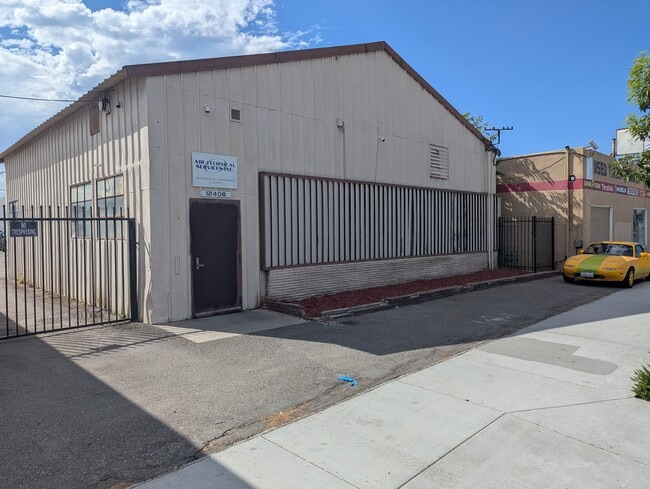
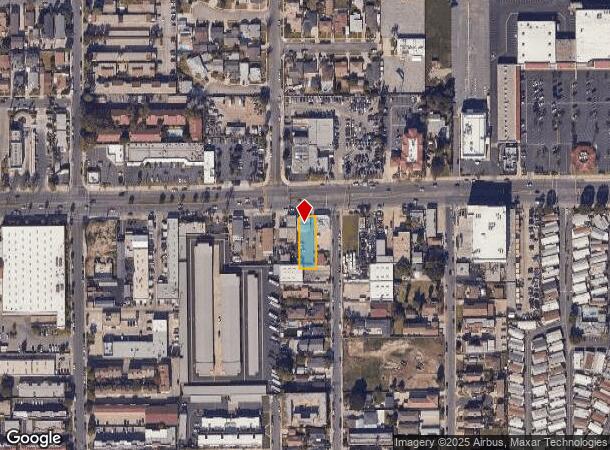
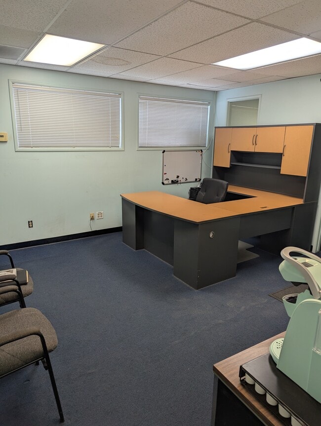
Property Record
12408 Carson St, Hawaiian Gardens, CA 90716
NEARBY LISTINGS FOR SALE OR LEASE
Property Detail
12408 Carson St
Los Angeles-Long Beach-Glendale, CA
Rancho Los Coyotes
7076-001-015
RANCHO LOS COYOTES SECTIONS TOWNSHIP ANDRANGE AS PER PATENTS BK 1 PG 493-494 ANDO R M 7425 PG 20-21 LOT COM S 89 27' W 1210.14 FT AND S 0 16'20 E 42.85 FT SEE ASSESSOR MAPBOOK FOR MISSING PORTION1/4 OF NE 1/4 OF SEC 18 T 4S R 11W
Lightindustrial
Los Angeles
X
California
06059C0104J
18
2024
0.21 AC
2025
Long Beach: Suburban
555212
Los Angeles
1,600 SF
DEMOGRAPHICS near 12408 Carson St
1 Mile
3 Mile
5 Mile
2024 Total Population
35,454
202,925
538,102
2029 Population
35,189
200,931
533,866
Pop Growth 2024-2029
(0.75%)
(0.98%)
(0.79%)
Average Age
39
42
42
2024 Total Households
10,545
65,117
174,098
HH Growth 2024-2029
(0.84%)
(1.16%)
(0.95%)
Median Household Inc
$103,131
$117,270
$107,722
Avg Household Size
3.20
3.00
3.00
2024 Avg HH Vehicles
2.00
2.00
2.00
Median Home Value
$739,005
$849,010
$797,991
Median Year Built
1968
1965
1964
Nearby Places
- Restaurants
- Banks
- Shops
- Fitness
- Groceries
PUBLIC TRANSPORTATION
COMMUTER RAIL
Norwalk/Santa Fe Springs (91 Line - Southern California Regional Rail Authority (Metrolink), Orange County Line - Southern California Regional Rail Authority (Metrolink))
DRIVE
WALK
Distance
Norwalk/Santa Fe Springs (91 Line - Southern California Regional Rail Authority (Metrolink), Orange County Line - Southern California Regional Rail Authority (Metrolink))
14 min
7.1 mi
Buena Park (91 Line - Southern California Regional Rail Authority (Metrolink), Orange County Line - Southern California Regional Rail Authority (Metrolink))
DRIVE
WALK
Distance
Buena Park (91 Line - Southern California Regional Rail Authority (Metrolink), Orange County Line - Southern California Regional Rail Authority (Metrolink))
13 min
8.0 mi
AIRPORT
Long Beach (Daugherty Field)
DRIVE
WALK
Distance
Long Beach (Daugherty Field)
13 min
7.3 mi
John Wayne/Orange County
DRIVE
WALK
Distance
John Wayne/Orange County
27 min
20.5 mi
Los Angeles International
DRIVE
WALK
Distance
Los Angeles International
33 min
26.4 mi
Freight Ports
Port of Long Beach
DRIVE
WALK
Distance
Port of Long Beach
20 min
11.1 mi
SALE & LEASE HISTORY
LISTING DATE
SALE/LEASE

Oct 14, 2025
For Sale
Nearby Properties
Address
Land Use
TOTAL SIZE
Lot Size
Zoning
Address
Land Use
TOTAL SIZE
Lot Size
Zoning
324,400 SF
55.03 AC
CECR
Address
Land Use
TOTAL SIZE
Lot Size
Zoning
927.44 AC
Address
Land Use
TOTAL SIZE
Lot Size
Zoning
235,971 SF
10.58 AC
HGC4*
Address
Land Use
TOTAL SIZE
Lot Size
Zoning
266,337 SF
2.40 AC
CE-ADP-16
Address
Land Use
TOTAL SIZE
Lot Size
Zoning
210,000 SF
9.18 AC
PC3
Address
Land Use
TOTAL SIZE
Lot Size
Zoning
203,371 SF
0.14 AC
HGC4*
Address
Land Use
TOTAL SIZE
Lot Size
Zoning
150,078 SF
9.66 AC
Address
Land Use
TOTAL SIZE
Lot Size
Zoning
247,536 SF
5.79 AC
CECR
Address
Land Use
TOTAL SIZE
Lot Size
Zoning
Address
Land Use
TOTAL SIZE
Lot Size
Zoning
11.86 AC
Address
Land Use
TOTAL SIZE
Lot Size
Zoning
8.09 AC
Address
Land Use
TOTAL SIZE
Lot Size
Zoning
120,094 SF
5.93 AC
Address
Land Use
TOTAL SIZE
Lot Size
Zoning
140,624 SF
4.35 AC
ATMRV1200*
Address
Land Use
TOTAL SIZE
Lot Size
Zoning
11.49 AC
Address
Land Use
TOTAL SIZE
Lot Size
Zoning
1,004,620 SF
19.73 AC
CECR
Address
Land Use
TOTAL SIZE
Lot Size
Zoning
105,069 SF
5.19 AC
Address
Land Use
TOTAL SIZE
Lot Size
Zoning
2,663 SF
1.43 AC
Address
Land Use
TOTAL SIZE
Lot Size
Zoning
3.04 AC
Address
Land Use
TOTAL SIZE
Lot Size
Zoning
80,339 SF
5.88 AC
ATCPD*
Address
Land Use
TOTAL SIZE
Lot Size
Zoning
266,036 SF
6.13 AC
ATCS
Address
Land Use
TOTAL SIZE
Lot Size
Zoning
83,600 SF
5.09 AC
R3
Address
Land Use
TOTAL SIZE
Lot Size
Zoning
165,343 SF
3.93 AC
Address
Land Use
TOTAL SIZE
Lot Size
Zoning
163,295 SF
6.17 AC
R3
Address
Land Use
TOTAL SIZE
Lot Size
Zoning
Address
Land Use
TOTAL SIZE
Lot Size
Zoning
175,482 SF
3.13 AC
HGC4*
Address
Land Use
TOTAL SIZE
Lot Size
Zoning
Address
Land Use
TOTAL SIZE
Lot Size
Zoning
3.84 AC
Address
Land Use
TOTAL SIZE
Lot Size
Zoning
2.95 AC
C
Address
Land Use
TOTAL SIZE
Lot Size
Zoning
7,200 SF
3.73 AC
Address
Land Use
TOTAL SIZE
Lot Size
Zoning
340,346 SF
5.74 AC
CECR
The World's #1 Commercial Real Estate Marketplace
Connect with us
© 2025 CoStar Group
The information above has been obtained from sources believed reliable. While we do not doubt its accuracy we have not verified it and make no guarantee, warranty or representation about it. It is your responsibility to independently confirm its accuracy and completeness. Any projections, opinions, assumptions, or estimates used are for example only and do not represent the current or future performance of the property. The value of this transaction to you depends on tax and other factors which should be evaluated by your tax, financial, and legal advisors. You and your advisors should conduct a careful, independent investigation of the property to determine to your satisfaction the suitability of the property for your needs.