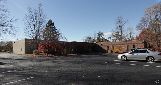
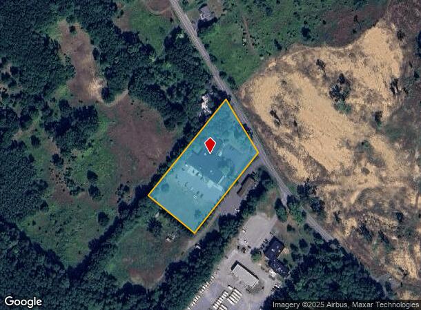
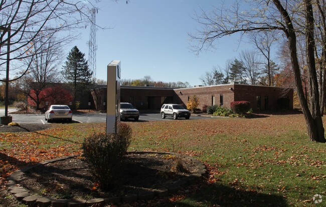
Property Record
1241 Kings Rd, Schenectady, NY 12303
NEARBY LISTINGS FOR SALE OR LEASE
Property Detail
1241 Kings Rd
012689-028-002-0003-016-000-0000
N-KINGS RD E-1279 S-7-65.1
Officebuilding
Albany
X
New York
36001C0157D
16.000
2025
2.10 AC
2024
W Outer Albany County
013804
Albany/Schenectady/Troy
16,038 SF
Albany-Schenectady-Troy, NY
DEMOGRAPHICS near 1241 Kings Rd
1 Mile
3 Mile
5 Mile
2024 Total Population
846
38,398
121,940
2029 Population
833
38,692
124,225
Pop Growth 2024-2029
(1.54%)
+ 0.77%
+ 1.87%
Average Age
44
43
41
2024 Total Households
348
15,712
47,457
HH Growth 2024-2029
(1.72%)
+ 0.88%
+ 2.09%
Median Household Inc
$132,197
$92,389
$84,208
Avg Household Size
2.40
2.40
2.30
2024 Avg HH Vehicles
2.00
2.00
2.00
Median Home Value
$274,766
$268,863
$241,520
Median Year Built
1971
1973
1967
Nearby Places
- Restaurants
- Banks
- Shops
- Fitness
- Groceries
PUBLIC TRANSPORTATION
COMMUTER RAIL
DRIVE
WALK
Distance
16 min
7.4 mi
AIRPORT
Albany International
DRIVE
WALK
Distance
Albany International
21 min
9.4 mi
Freight Ports
Albany, NY Port
DRIVE
WALK
Distance
Albany, NY Port
26 min
14.2 mi
Nearby Properties
Address
Land Use
TOTAL SIZE
Lot Size
Zoning
Address
Land Use
TOTAL SIZE
Lot Size
Zoning
11,700 SF
43.80 AC
R2
Address
Land Use
TOTAL SIZE
Lot Size
Zoning
190 AC
LC
Address
Land Use
TOTAL SIZE
Lot Size
Zoning
47,424 SF
37.60 AC
MR
Address
Land Use
TOTAL SIZE
Lot Size
Zoning
98.20 AC
LC
Address
Land Use
TOTAL SIZE
Lot Size
Zoning
80.10 AC
LC
Address
Land Use
TOTAL SIZE
Lot Size
Zoning
279,150 SF
21.10 AC
CO
Address
Land Use
TOTAL SIZE
Lot Size
Zoning
266,600 SF
22.60 AC
47
Address
Land Use
TOTAL SIZE
Lot Size
Zoning
9,000 SF
10.32 AC
GB
Address
Land Use
TOTAL SIZE
Lot Size
Zoning
103.30 AC
LC
Address
Land Use
TOTAL SIZE
Lot Size
Zoning
4,680 SF
11.39 AC
CH
Address
Land Use
TOTAL SIZE
Lot Size
Zoning
161,797 SF
13.69 AC
GB
Address
Land Use
TOTAL SIZE
Lot Size
Zoning
19,968 SF
12 AC
MR
Address
Land Use
TOTAL SIZE
Lot Size
Zoning
78,326 SF
27.47 AC
R40
Address
Land Use
TOTAL SIZE
Lot Size
Zoning
45 AC
LC
Address
Land Use
TOTAL SIZE
Lot Size
Zoning
183,140 SF
9.85 AC
CM
Address
Land Use
TOTAL SIZE
Lot Size
Zoning
86,049 SF
17.10 AC
RO30
Address
Land Use
TOTAL SIZE
Lot Size
Zoning
25,112 SF
13.16 AC
04 - FARM
Address
Land Use
TOTAL SIZE
Lot Size
Zoning
Address
Land Use
TOTAL SIZE
Lot Size
Zoning
8,832 SF
6.40 AC
MR
Address
Land Use
TOTAL SIZE
Lot Size
Zoning
120,373 SF
9.68 AC
CS
Address
Land Use
TOTAL SIZE
Lot Size
Zoning
99,620 SF
15 AC
45
Address
Land Use
TOTAL SIZE
Lot Size
Zoning
117 AC
06 - INDUS
Address
Land Use
TOTAL SIZE
Lot Size
Zoning
68,080 SF
6.22 AC
CS
Address
Land Use
TOTAL SIZE
Lot Size
Zoning
30.20 AC
LC
Address
Land Use
TOTAL SIZE
Lot Size
Zoning
68,000 SF
11.20 AC
TH
Address
Land Use
TOTAL SIZE
Lot Size
Zoning
89,589 SF
17.40 AC
45
Address
Land Use
TOTAL SIZE
Lot Size
Zoning
7,148 SF
7.20 AC
PUD
Address
Land Use
TOTAL SIZE
Lot Size
Zoning
151,527 SF
9.90 AC
CM
Address
Land Use
TOTAL SIZE
Lot Size
Zoning
40,768 SF
1.66 AC
CO
Address
Land Use
TOTAL SIZE
Lot Size
Zoning
61,006 SF
8.10 AC
R15
The World's #1 Commercial Real Estate Marketplace
Connect with us
© 2025 CoStar Group
The information above has been obtained from sources believed reliable. While we do not doubt its accuracy we have not verified it and make no guarantee, warranty or representation about it. It is your responsibility to independently confirm its accuracy and completeness. Any projections, opinions, assumptions, or estimates used are for example only and do not represent the current or future performance of the property. The value of this transaction to you depends on tax and other factors which should be evaluated by your tax, financial, and legal advisors. You and your advisors should conduct a careful, independent investigation of the property to determine to your satisfaction the suitability of the property for your needs.