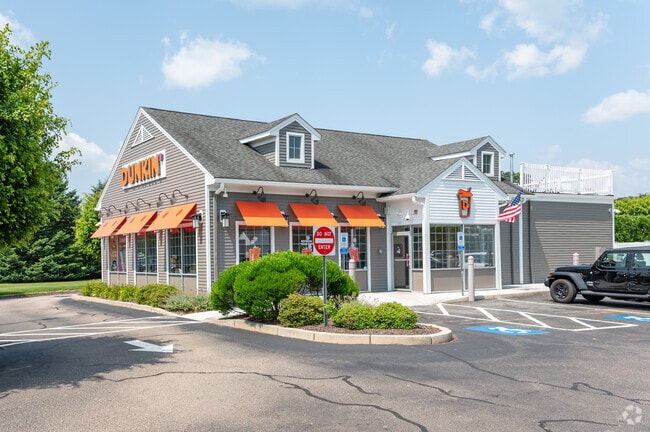
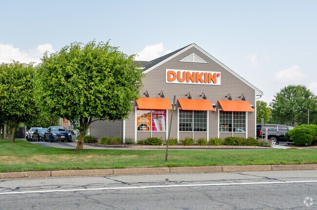
Property Record
1241 Ten Rod Rd, North Kingstown, RI 02852

NEARBY LISTINGS FOR SALE OR LEASE
Property Detail
1241 Ten Rod Rd
Commercialbuilding
Washington
X
Rhode Island
44009C0085J
1.26 AC
2025
Washington County
2025
Providence
050301
Providence-Warwick, RI-MA
2,687 SF
111 004
DEMOGRAPHICS near 1241 Ten Rod Rd
1 Mile
3 Mile
5 Mile
2024 Total Population
1,947
15,278
37,057
2029 Population
1,912
15,195
36,956
Pop Growth 2024-2029
(1.80%)
(0.54%)
(0.27%)
Average Age
43
43
43
2024 Total Households
690
6,204
14,357
HH Growth 2024-2029
(2.17%)
(0.81%)
(0.59%)
Median Household Inc
$116,249
$95,546
$106,450
Avg Household Size
2.70
2.40
2.50
2024 Avg HH Vehicles
2.00
2.00
2.00
Median Home Value
$550,746
$458,222
$466,516
Median Year Built
1988
1975
1974
Nearby Places
Map Layers
Map Styles
 Street
 Aerial
- Restaurants
- Banks
- Shops
- Fitness
- Groceries
PUBLIC TRANSPORTATION
COMMUTER RAIL
Wickford Junction (Providence/Stoughton Line - MBTA)
DRIVE
WALK
Distance
Wickford Junction (Providence/Stoughton Line - MBTA)
2 min
11 min
0.6 mi
Kingston Amtrak Station (Northeast Regional - Amtrak)
DRIVE
WALK
Distance
Kingston Amtrak Station (Northeast Regional - Amtrak)
15 min
8.9 mi
AIRPORT
Rhode Island Tf Green International
DRIVE
WALK
Distance
Rhode Island Tf Green International
23 min
14.0 mi
Freight Ports
Port of Davisville, RI
DRIVE
WALK
Distance
Port of Davisville, RI
16 min
7.0 mi
Nearby Properties
Address
Land Use
TOTAL SIZE
Lot Size
Zoning
Address
Land Use
TOTAL SIZE
Lot Size
Zoning
83.30 AC
F1
Address
Land Use
TOTAL SIZE
Lot Size
Zoning
8.10 AC
PR
Address
Land Use
TOTAL SIZE
Lot Size
Zoning
196,759 SF
33.67 AC
QBPD
Address
Land Use
TOTAL SIZE
Lot Size
Zoning
3,417 SF
7.13 AC
PR
Address
Land Use
TOTAL SIZE
Lot Size
Zoning
141,701 SF
12 AC
WJ
Address
Land Use
TOTAL SIZE
Lot Size
Zoning
13.28 AC
GB
Address
Land Use
TOTAL SIZE
Lot Size
Zoning
125,393 SF
15.33 AC
GB
Address
Land Use
TOTAL SIZE
Lot Size
Zoning
8.92 AC
PR
Address
Land Use
TOTAL SIZE
Lot Size
Zoning
25.10 AC
QBPD
Address
Land Use
TOTAL SIZE
Lot Size
Zoning
12.68 AC
PR
Address
Land Use
TOTAL SIZE
Lot Size
Zoning
237,726 SF
3.36 AC
WJ
Address
Land Use
TOTAL SIZE
Lot Size
Zoning
15.50 AC
PVD
Address
Land Use
TOTAL SIZE
Lot Size
Zoning
8.85 AC
PR
Address
Land Use
TOTAL SIZE
Lot Size
Zoning
15.90 AC
QBPD
Address
Land Use
TOTAL SIZE
Lot Size
Zoning
42,533 SF
12.60 AC
GB
Address
Land Use
TOTAL SIZE
Lot Size
Zoning
72,831 SF
2.98 AC
PR
Address
Land Use
TOTAL SIZE
Lot Size
Zoning
62,949 SF
12.28 AC
P
Address
Land Use
TOTAL SIZE
Lot Size
Zoning
4.92 AC
CH
Address
Land Use
TOTAL SIZE
Lot Size
Zoning
41,456 SF
5.08 AC
PR
Address
Land Use
TOTAL SIZE
Lot Size
Zoning
49,367 SF
14.27 AC
P
Address
Land Use
TOTAL SIZE
Lot Size
Zoning
49.89 AC
OS/P
Address
Land Use
TOTAL SIZE
Lot Size
Zoning
3.08 AC
GB
Address
Land Use
TOTAL SIZE
Lot Size
Zoning
120 AC
LI
Address
Land Use
TOTAL SIZE
Lot Size
Zoning
2.98 AC
WB
Address
Land Use
TOTAL SIZE
Lot Size
Zoning
40,006 SF
15.68 AC
P
Address
Land Use
TOTAL SIZE
Lot Size
Zoning
32,663 SF
10.50 AC
P
Address
Land Use
TOTAL SIZE
Lot Size
Zoning
39,060 SF
8.71 AC
RR
Address
Land Use
TOTAL SIZE
Lot Size
Zoning
31,152 SF
5.36 AC
M/LI
Address
Land Use
TOTAL SIZE
Lot Size
Zoning
Address
Land Use
TOTAL SIZE
Lot Size
Zoning
63,582 SF
6.74 AC
QBPD
The World's #1 Commercial Real Estate Marketplace
Connect with us
© 2026 CoStar Group
The information above has been obtained from sources believed reliable. While we do not doubt its accuracy we have not verified it and make no guarantee, warranty or representation about it. It is your responsibility to independently confirm its accuracy and completeness. Any projections, opinions, assumptions, or estimates used are for example only and do not represent the current or future performance of the property. The value of this transaction to you depends on tax and other factors which should be evaluated by your tax, financial, and legal advisors. You and your advisors should conduct a careful, independent investigation of the property to determine to your satisfaction the suitability of the property for your needs.