Property Record
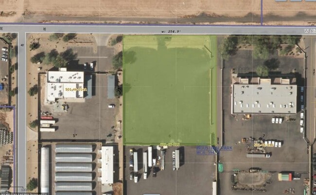
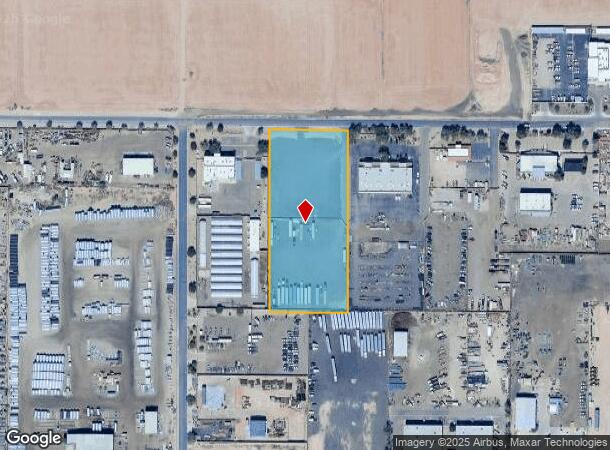
12425 W Alice Ave, El Mirage, AZ 85335
This Property Is For Sale
NEARBY LISTINGS FOR SALE OR LEASE
Property Detail
12425 W Alice Ave
Phoenix-Mesa-Scottsdale, AZ
Luke Industrial Park
501-46-015
LUKE INDUSTRIAL PARK MCR 594-15
Industrialacreage
Maricopa
X
Arizona
04013C1690M
6
2025
3.50 AC
2025
Loop 303/Surprise
061043
Phoenix
DEMOGRAPHICS near 12425 W Alice Ave
1 Mile
3 Mile
5 Mile
2024 Total Population
115
53,570
207,864
2029 Population
125
58,189
226,175
Pop Growth 2024-2029
+ 8.70%
+ 8.62%
+ 8.81%
Average Age
36
38
40
2024 Total Households
38
18,887
74,193
HH Growth 2024-2029
+ 7.89%
+ 8.70%
+ 9.01%
Median Household Inc
$70,384
$66,138
$69,466
Avg Household Size
3.00
2.80
2.70
2024 Avg HH Vehicles
2.00
2.00
2.00
Median Home Value
$219,444
$259,636
$293,941
Median Year Built
1985
1995
2000
Nearby Places
- Restaurants
- Banks
- Shops
- Fitness
- Groceries
PUBLIC TRANSPORTATION
AIRPORT
Phoenix Sky Harbor International
DRIVE
WALK
Distance
Phoenix Sky Harbor International
40 min
27.8 mi
Freight Ports
Port of San Diego
DRIVE
WALK
Distance
Port of San Diego
389 min
347.8 mi
Nearby Properties
Address
Land Use
TOTAL SIZE
Lot Size
Zoning
Address
Land Use
TOTAL SIZE
Lot Size
Zoning
138.98 AC
Address
Land Use
TOTAL SIZE
Lot Size
Zoning
71.40 AC
Address
Land Use
TOTAL SIZE
Lot Size
Zoning
35.74 AC
Address
Land Use
TOTAL SIZE
Lot Size
Zoning
303,419 SF
31.47 AC
Address
Land Use
TOTAL SIZE
Lot Size
Zoning
1,188,764 SF
631.19 AC
AP
Address
Land Use
TOTAL SIZE
Lot Size
Zoning
53.02 AC
Address
Land Use
TOTAL SIZE
Lot Size
Zoning
52.99 AC
Address
Land Use
TOTAL SIZE
Lot Size
Zoning
16,341 SF
174.45 AC
R-43
Address
Land Use
TOTAL SIZE
Lot Size
Zoning
510,342 SF
51.45 AC
LUKEAFB
Address
Land Use
TOTAL SIZE
Lot Size
Zoning
844,524 SF
130.66 AC
LUKEAFB
Address
Land Use
TOTAL SIZE
Lot Size
Zoning
351,775 SF
53.72 AC
AP
Address
Land Use
TOTAL SIZE
Lot Size
Zoning
531,110 SF
124.24 AC
I-1
Address
Land Use
TOTAL SIZE
Lot Size
Zoning
294,360 SF
21.69 AC
EI
Address
Land Use
TOTAL SIZE
Lot Size
Zoning
225,457 SF
70.07 AC
PAD
Address
Land Use
TOTAL SIZE
Lot Size
Zoning
455,936 SF
23.97 AC
Address
Land Use
TOTAL SIZE
Lot Size
Zoning
20,948 SF
2.39 AC
R-6
Address
Land Use
TOTAL SIZE
Lot Size
Zoning
291,028 SF
20.62 AC
Address
Land Use
TOTAL SIZE
Lot Size
Zoning
327,311 SF
21.14 AC
RM-1
Address
Land Use
TOTAL SIZE
Lot Size
Zoning
113,020 SF
16.37 AC
R-43
Address
Land Use
TOTAL SIZE
Lot Size
Zoning
418,305 SF
24.06 AC
PAD
Address
Land Use
TOTAL SIZE
Lot Size
Zoning
242,740 SF
20.21 AC
M1
Address
Land Use
TOTAL SIZE
Lot Size
Zoning
106,356 SF
14.16 AC
PAD
Address
Land Use
TOTAL SIZE
Lot Size
Zoning
93,832 SF
79 AC
AG
Address
Land Use
TOTAL SIZE
Lot Size
Zoning
707,380 SF
46.26 AC
I-2
Address
Land Use
TOTAL SIZE
Lot Size
Zoning
116,323 SF
17.38 AC
R-8
Address
Land Use
TOTAL SIZE
Lot Size
Zoning
91,600 SF
18.61 AC
R-43
Address
Land Use
TOTAL SIZE
Lot Size
Zoning
82,320 SF
36.07 AC
AP
Address
Land Use
TOTAL SIZE
Lot Size
Zoning
220,240 SF
13.68 AC
Address
Land Use
TOTAL SIZE
Lot Size
Zoning
112,957 SF
17.40 AC
PAD
Address
Land Use
TOTAL SIZE
Lot Size
Zoning
97,910 SF
26.16 AC
PAD
The World's #1 Commercial Real Estate Marketplace
Connect with us
© 2025 CoStar Group
The information above has been obtained from sources believed reliable. While we do not doubt its accuracy we have not verified it and make no guarantee, warranty or representation about it. It is your responsibility to independently confirm its accuracy and completeness. Any projections, opinions, assumptions, or estimates used are for example only and do not represent the current or future performance of the property. The value of this transaction to you depends on tax and other factors which should be evaluated by your tax, financial, and legal advisors. You and your advisors should conduct a careful, independent investigation of the property to determine to your satisfaction the suitability of the property for your needs.