Property Record
1244 E Heath Church Rd, Lexington, NC 27292

NEARBY LISTINGS FOR SALE OR LEASE
-
-
View all Lexington listings for sale on LoopNet.com
Property Detail
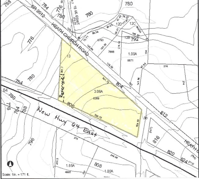
1244 E Heath Church Rd
05-015-A-000-0013-0-0-0
Carry Heirs Property
Publicstorage
P=15 53-54 L13 BK2671-1366
X
Davidson
3710675400J
North Carolina
2025
3.03 AC
2025
North Davidson County
061904
Greensboro/Winston-Salem
15,527 SF
Winston-Salem, NC
DEMOGRAPHICS near 1244 E Heath Church Rd
1 Mile
3 Mile
5 Mile
2024 Total Population
522
5,479
22,984
2029 Population
540
5,708
24,123
Pop Growth 2024-2029
+ 3.45%
+ 4.18%
+ 4.96%
Average Age
42
43
43
2024 Total Households
213
2,272
9,314
HH Growth 2024-2029
+ 3.29%
+ 4.05%
+ 4.86%
Median Household Inc
$39,530
$47,427
$45,742
Avg Household Size
2.40
2.40
2.40
2024 Avg HH Vehicles
2.00
2.00
2.00
Median Home Value
$188,775
$160,014
$165,438
Median Year Built
1980
1981
1979
Nearby Places
Map Layers
Map Styles
 Street
 Aerial
- Restaurants
- Banks
- Shops
- Fitness
- Groceries
PUBLIC TRANSPORTATION
AIRPORT
Piedmont Triad International
DRIVE
WALK
Distance
Piedmont Triad International
50 min
40.3 mi
Concord-Padgett Regional
DRIVE
WALK
Distance
Concord-Padgett Regional
59 min
49.0 mi
Nearby Properties
Address
Land Use
TOTAL SIZE
Lot Size
Zoning
Address
Land Use
TOTAL SIZE
Lot Size
Zoning
122,218 SF
106.02 AC
HI
Address
Land Use
TOTAL SIZE
Lot Size
Zoning
84,523 SF
26.56 AC
RA1
Address
Land Use
TOTAL SIZE
Lot Size
Zoning
45,732 SF
5.82 AC
LI
Address
Land Use
TOTAL SIZE
Lot Size
Zoning
4,380 SF
21.17 AC
RA3
Address
Land Use
TOTAL SIZE
Lot Size
Zoning
202.55 AC
LICZ
Address
Land Use
TOTAL SIZE
Lot Size
Zoning
41,784 SF
12.77 AC
OI
Address
Land Use
TOTAL SIZE
Lot Size
Zoning
14,648 SF
15.93 AC
OI
Address
Land Use
TOTAL SIZE
Lot Size
Zoning
19,061 SF
20.83 AC
OI
Address
Land Use
TOTAL SIZE
Lot Size
Zoning
7,650 SF
26.91 AC
OI
Address
Land Use
TOTAL SIZE
Lot Size
Zoning
547 SF
123.66 AC
HI
Address
Land Use
TOTAL SIZE
Lot Size
Zoning
7,080 SF
364.78 AC
RA3
Address
Land Use
TOTAL SIZE
Lot Size
Zoning
65,252 SF
147.85 AC
HI
Address
Land Use
TOTAL SIZE
Lot Size
Zoning
37.83 AC
CS
Address
Land Use
TOTAL SIZE
Lot Size
Zoning
8,883 SF
18.82 AC
RA2
Address
Land Use
TOTAL SIZE
Lot Size
Zoning
9,337 SF
6.98 AC
RA3
Address
Land Use
TOTAL SIZE
Lot Size
Zoning
68.73 AC
LICU
Address
Land Use
TOTAL SIZE
Lot Size
Zoning
6,678 SF
38.02 AC
HC
Address
Land Use
TOTAL SIZE
Lot Size
Zoning
32,525 SF
1.75 AC
HI
Address
Land Use
TOTAL SIZE
Lot Size
Zoning
111.13 AC
RA3
Address
Land Use
TOTAL SIZE
Lot Size
Zoning
4,022 SF
5.80 AC
RA3
Address
Land Use
TOTAL SIZE
Lot Size
Zoning
49,270 SF
10.08 AC
HI
Address
Land Use
TOTAL SIZE
Lot Size
Zoning
5,596 SF
28.92 AC
LI
Address
Land Use
TOTAL SIZE
Lot Size
Zoning
12,133 SF
8.72 AC
RA2
Address
Land Use
TOTAL SIZE
Lot Size
Zoning
15,219 SF
15.10 AC
HI
Address
Land Use
TOTAL SIZE
Lot Size
Zoning
15,179 SF
2.13 AC
OI
Address
Land Use
TOTAL SIZE
Lot Size
Zoning
13,120 SF
14.66 AC
RA3
Address
Land Use
TOTAL SIZE
Lot Size
Zoning
9,756 SF
5 AC
RA3
Address
Land Use
TOTAL SIZE
Lot Size
Zoning
35.16 AC
HI
Address
Land Use
TOTAL SIZE
Lot Size
Zoning
1,800 SF
8.31 AC
HC
The World's #1 Commercial Real Estate Marketplace
Connect with us
© 2026 CoStar Group
The information above has been obtained from sources believed reliable. While we do not doubt its accuracy we have not verified it and make no guarantee, warranty or representation about it. It is your responsibility to independently confirm its accuracy and completeness. Any projections, opinions, assumptions, or estimates used are for example only and do not represent the current or future performance of the property. The value of this transaction to you depends on tax and other factors which should be evaluated by your tax, financial, and legal advisors. You and your advisors should conduct a careful, independent investigation of the property to determine to your satisfaction the suitability of the property for your needs.