Property Record
12447 Maple St, Ashland, VA 23005
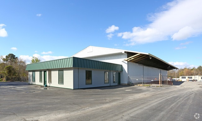

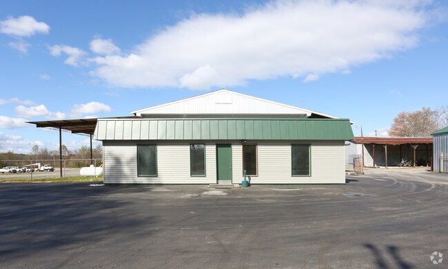
Property Detail
12447 Maple St
7779-66-7016
12400 BLK MAPLE STREET
Commercialnec
Hanover
M-1
Virginia
AE The base floodplain where base flood elevations are provided. AE Zones are now used on new format FIRMs instead of A1-A30 Zones.
11.30 AC
2025
I-95 North/Ashland
2025
Richmond VA
320602
Richmond, VA
NEARBY LISTINGS FOR SALE OR LEASE
DEMOGRAPHICS near 12447 Maple St
1 mile
3 mile
5 mile
2025 Total Population
3,252
13,552
32,022
2030 Population
3,372
14,133
33,240
Pop Growth 2025-2030
+ 3.69%
+ 4.29%
+ 3.80%
Average Age
43
41
41
2025 Total Households
1,365
5,125
12,001
HH Growth 2025-2030
+ 3.81%
+ 4.51%
+ 4.00%
Median Household Inc
$67,463
$87,450
$109,650
Avg Household Size
2.40
2.40
2.50
2025 Avg HH Vehicles
2.00
2.00
2.00
Median Home Value
$316,794
$377,317
$420,039
Median Year Built
1981
1984
1993
Nearby Places
Map Layers
Map Styles
 Street
 Aerial
Layers
 Traffic
 Biking
Places
Listings with unknown addresses are not visible on the map
- Restaurants
- Banks
- Shops
- Fitness
- Groceries
PUBLIC TRANSPORTATION
AIRPORT
Richmond International
Drive
Walk
Distance
Richmond International
36 min
24.4 mi
SALE & LEASE HISTORY
LISTING DATE
SALE/LEASE

Sep 25, 2016
For Lease
Nearby Properties
Address
Land Use
TOTAL SIZE
Lot Size
Zoning
Address
Land Use
TOTAL SIZE
Lot Size
Zoning
36.08 AC
HE
Address
Land Use
TOTAL SIZE
Lot Size
Zoning
26,583 SF
9 AC
HE
Address
Land Use
TOTAL SIZE
Lot Size
Zoning
50.20 AC
M-2
Address
Land Use
TOTAL SIZE
Lot Size
Zoning
30.94 AC
M-2
Address
Land Use
TOTAL SIZE
Lot Size
Zoning
3.60 AC
HE
Address
Land Use
TOTAL SIZE
Lot Size
Zoning
320,540 SF
18.50 AC
M-2
Address
Land Use
TOTAL SIZE
Lot Size
Zoning
194,598 SF
14.50 AC
R-5
Address
Land Use
TOTAL SIZE
Lot Size
Zoning
280,900 SF
22.69 AC
M-1
Address
Land Use
TOTAL SIZE
Lot Size
Zoning
22.80 AC
A-1
Address
Land Use
TOTAL SIZE
Lot Size
Zoning
220,499 SF
19.01 AC
PSC
Address
Land Use
TOTAL SIZE
Lot Size
Zoning
293,114 SF
15.56 AC
M-2
Address
Land Use
TOTAL SIZE
Lot Size
Zoning
25.93 AC
M-2
Address
Land Use
TOTAL SIZE
Lot Size
Zoning
24.80 AC
M-2
Address
Land Use
TOTAL SIZE
Lot Size
Zoning
24.17 AC
M-1
Address
Land Use
TOTAL SIZE
Lot Size
Zoning
24.21 AC
RR-1
Address
Land Use
TOTAL SIZE
Lot Size
Zoning
215,072 SF
16.32 AC
M-2
Address
Land Use
TOTAL SIZE
Lot Size
Zoning
43.11 AC
PMH
Address
Land Use
TOTAL SIZE
Lot Size
Zoning
17.80 AC
B-3
Address
Land Use
TOTAL SIZE
Lot Size
Zoning
10.50 AC
R-2
Address
Land Use
TOTAL SIZE
Lot Size
Zoning
151,540 SF
21.15 AC
PSC
Address
Land Use
TOTAL SIZE
Lot Size
Zoning
15.83 AC
M-2
Address
Land Use
TOTAL SIZE
Lot Size
Zoning
14.43 AC
M-2
Address
Land Use
TOTAL SIZE
Lot Size
Zoning
23.97 AC
RR-1
Address
Land Use
TOTAL SIZE
Lot Size
Zoning
8.73 AC
M-2
Address
Land Use
TOTAL SIZE
Lot Size
Zoning
7.39 AC
M-2
Address
Land Use
TOTAL SIZE
Lot Size
Zoning
40,415 SF
29.10 AC
M-2
Address
Land Use
TOTAL SIZE
Lot Size
Zoning
66,910 SF
1.94 AC
B-2
Address
Land Use
TOTAL SIZE
Lot Size
Zoning
57,385 SF
2.38 AC
B-3
Address
Land Use
TOTAL SIZE
Lot Size
Zoning
136,144 SF
6.27 AC
M-2
Address
Land Use
TOTAL SIZE
Lot Size
Zoning
48,622 SF
24.28 AC
POB
The World's #1 Commercial Real Estate Marketplace
Connect with us
© 2026 CoStar Group
The information above has been obtained from sources believed reliable. While we do not doubt its accuracy we have not verified it and make no guarantee, warranty or representation about it. It is your responsibility to independently confirm its accuracy and completeness. Any projections, opinions, assumptions, or estimates used are for example only and do not represent the current or future performance of the property. The value of this transaction to you depends on tax and other factors which should be evaluated by your tax, financial, and legal advisors. You and your advisors should conduct a careful, independent investigation of the property to determine to your satisfaction the suitability of the property for your needs.