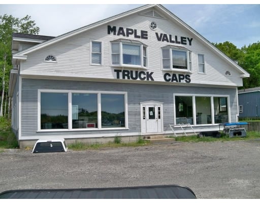
Property Record
1245 Bernardston Rd, Greenfield, MA 01301
NEARBY LISTINGS FOR SALE OR LEASE
Property Detail
1245 Bernardston Rd
GREE-000011R-000097
Franklin
Commercialofficeresidentialmixeduse
Massachusetts
2025
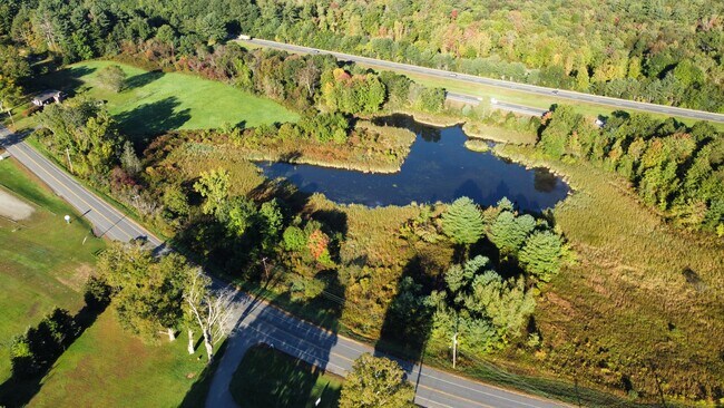
32.44 AC
2025
Franklin County
041100
Hartford
23,038 SF
Greenfield Town, MA
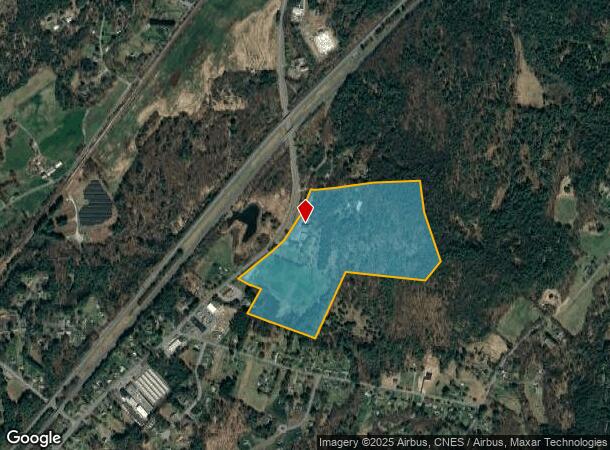
DEMOGRAPHICS near 1245 Bernardston Rd
1 Mile
3 Mile
5 Mile
2024 Total Population
648
8,260
26,512
2029 Population
652
8,219
26,349
Pop Growth 2024-2029
+ 0.62%
(0.50%)
(0.61%)
Average Age
47
45
45
2024 Total Households
279
3,615
12,035
HH Growth 2024-2029
+ 0.36%
(0.53%)
(0.58%)
Median Household Inc
$88,815
$73,111
$62,239
Avg Household Size
2.30
2.20
2.10
2024 Avg HH Vehicles
2.00
2.00
2.00
Median Home Value
$300,943
$279,882
$256,057
Median Year Built
1963
1954
1951
Nearby Places
Map Layers
Map Styles
 Street
 Aerial
- Restaurants
- Banks
- Shops
- Fitness
- Groceries
PUBLIC TRANSPORTATION
COMMUTER RAIL
Greenfield Amtrak Station (Valley Flyer - Amtrak, Vermonter - Amtrak)
DRIVE
WALK
Distance
Greenfield Amtrak Station (Valley Flyer - Amtrak, Vermonter - Amtrak)
8 min
4.8 mi
Freight Ports
Albany, NY Port
DRIVE
WALK
Distance
Albany, NY Port
143 min
117.0 mi
SALE & LEASE HISTORY
LISTING DATE
SALE/LEASE

Oct 19, 2021
For Sale
Nearby Properties
Address
Land Use
TOTAL SIZE
Lot Size
Zoning
Address
Land Use
TOTAL SIZE
Lot Size
Zoning
160,366 SF
56.38 AC
RB
Address
Land Use
TOTAL SIZE
Lot Size
Zoning
2 AC
R1
Address
Land Use
TOTAL SIZE
Lot Size
Zoning
40.50 AC
ID
Address
Land Use
TOTAL SIZE
Lot Size
Zoning
29 AC
RA
Address
Land Use
TOTAL SIZE
Lot Size
Zoning
68,667 SF
15 AC
B
Address
Land Use
TOTAL SIZE
Lot Size
Zoning
60,844 SF
15.31 AC
GC
Address
Land Use
TOTAL SIZE
Lot Size
Zoning
89,667 SF
15 AC
PI
Address
Land Use
TOTAL SIZE
Lot Size
Zoning
32,409 SF
12 AC
RA
Address
Land Use
TOTAL SIZE
Lot Size
Zoning
85,138 SF
19.70 AC
PI
Address
Land Use
TOTAL SIZE
Lot Size
Zoning
53,952 SF
5.51 AC
LC
Address
Land Use
TOTAL SIZE
Lot Size
Zoning
54,998 SF
5 AC
I
Address
Land Use
TOTAL SIZE
Lot Size
Zoning
54,340 SF
13.92 AC
PI
Address
Land Use
TOTAL SIZE
Lot Size
Zoning
15,784 SF
2 AC
R1
Address
Land Use
TOTAL SIZE
Lot Size
Zoning
12,258 SF
1.60 AC
CB
Address
Land Use
TOTAL SIZE
Lot Size
Zoning
37,439 SF
10.01 AC
RA
Address
Land Use
TOTAL SIZE
Lot Size
Zoning
50,400 SF
3.23 AC
GC
Address
Land Use
TOTAL SIZE
Lot Size
Zoning
40,120 SF
1.05 AC
CB
Address
Land Use
TOTAL SIZE
Lot Size
Zoning
25,384 SF
16.65 AC
PI
Address
Land Use
TOTAL SIZE
Lot Size
Zoning
35,500 SF
5.06 AC
ID
Address
Land Use
TOTAL SIZE
Lot Size
Zoning
24,020 SF
5 AC
B
Address
Land Use
TOTAL SIZE
Lot Size
Zoning
23,106 SF
0.57 AC
NB
Address
Land Use
TOTAL SIZE
Lot Size
Zoning
7,622 SF
0.35 AC
NB
Address
Land Use
TOTAL SIZE
Lot Size
Zoning
3,136 SF
1.01 AC
NB
Address
Land Use
TOTAL SIZE
Lot Size
Zoning
297 AC
R1
Address
Land Use
TOTAL SIZE
Lot Size
Zoning
26,604 SF
4.80 AC
PI
Address
Land Use
TOTAL SIZE
Lot Size
Zoning
31,530 SF
4.65 AC
PI
Address
Land Use
TOTAL SIZE
Lot Size
Zoning
1,452 SF
1.80 AC
LC
Address
Land Use
TOTAL SIZE
Lot Size
Zoning
7,058 SF
0.28 AC
NB
Address
Land Use
TOTAL SIZE
Lot Size
Zoning
18,786 SF
2.43 AC
RA
Address
Land Use
TOTAL SIZE
Lot Size
Zoning
5,790 SF
219.02 AC
RC
The World's #1 Commercial Real Estate Marketplace
Connect with us
© 2025 CoStar Group
The information above has been obtained from sources believed reliable. While we do not doubt its accuracy we have not verified it and make no guarantee, warranty or representation about it. It is your responsibility to independently confirm its accuracy and completeness. Any projections, opinions, assumptions, or estimates used are for example only and do not represent the current or future performance of the property. The value of this transaction to you depends on tax and other factors which should be evaluated by your tax, financial, and legal advisors. You and your advisors should conduct a careful, independent investigation of the property to determine to your satisfaction the suitability of the property for your needs.